")
A proposed pedestrian and bicycle improvements project near the Vienna/Fairfax-GMU Metro station is taking shape and now includes plans to accommodate community needs in the interim.
During a virtual public hearing on the design of the $9.5 million project last Wednesday (Nov. 17), Virginia Department of Transportation staff shared an interim plan to improve the bicycle and pedestrian network north of the Vienna Metro station and Oakton High School.
The interim plan will support the needs of bicyclists in the area while taking into account the timeline for the larger Transform 66 Outside the Beltway project, which will add more than 11 miles of trails from Gallows Road in Dunn Loring to Centreville, according to VDOT.
The interim project calls for:
- New signs and pavement markings
- A buffered bicycle lane on Sutton Road between Sutton Green Court and Country Creek Road
- A two-way, street-level cycle track on eastbound Country Creek between Sutton and the Metro’s north parking lot entrance
Work is expected to begin in mid-2022 — around the same time the I-66 Trail network is complete.
VDOT project manager Zamir Mirza estimated that the interim project will be completed in late 2022. It’s intended to serve the needs of bicyclists until the permanent project is finished, which isn’t expected to be until early 2026, with construction starting in late 2024.
This interim plan is not funded as a part of the original project, however, and has an estimated cost of $1 million. It utilizes the existing roadway width and is not expected to affect utilities or require any right-of-way acquisitions.
Mirza added that the only component of the interim project that will remain permanently is some pedestrian push buttons to improve the traffic signaling.
Aside from the proposed interim plan, the Vienna Metro improvements project is largely unaltered from March, according to Mirza. He added the location of the shared use path and bicycle track remain the same along the three road segments.
For the permanent project, VDOT will construct a 10-foot-wide, shared-use path on Blake Lane and Sutton from the I-66 bridge to Country Creek Road. Crosswalks and refuge islands will be added at Blake Lane and the Oakton High School entrance, along with a raised crossing at Sutton Green Court.
Sutton will also get 12 or 13 street parking spaces added on the northbound section and 16 to 18 more spaces on the southbound.
Country Creek improvements include hatched shoulder areas with a 12-foot-wide, two-way bicycle track and a 6-foot-wide sidewalk, with crosswalks at Sutton Road and the I-66 ramp/Village Spring Lane.
A new traffic signal at this location will realign the I-66 ramp “to be better oriented with Village Spring Lane” and eliminate the free-flowing right turn currently there, according to Mirza. An additional eight to 10 parking spaces will be added on the westbound side of the road.
The Virginia Center Boulevard improvements include a two-way, 12-foot-wide bicycle track and a 6-foot-wide sidewalk. There will also be a Capital Bikeshare station, crosswalks at the Metro bus entrance and exit, and intersection improvements at Vaden Drive.
Mirza confirmed that there will be no private property taken from individual landowners, but “slivers” of land will be acquired from homeowners’ associations, Washington Metropolitan Area Transit Authority, and the Fairfax County Board of Supervisors.
The new parking added by the project is currently slated to be free, but Mirza said he was unsure of the county’s future intentions for those spaces.
Community members can submit comments on the project until Dec. 3 via email, phone (703-259-1794), mail, online, or in-person by request during business hours at VDOT’s Northern Virginia District office.
Emails should be made out to [email protected] with a reference to “Vienna Metro Bicycle and Pedestrian Improvements” in the subject line.
Mail can be sent to Zamir Mirza, VDOT’s Northern Virginia District, 4975 Alliance Drive, Fairfax, VA 22030.
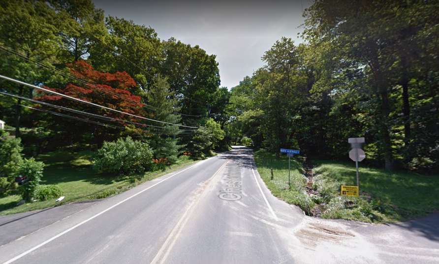
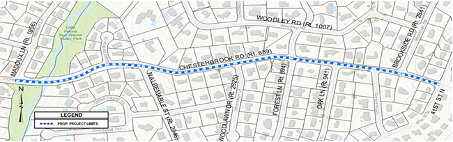
Fairfax County’s plan to build more sidewalk on Chesterbrook Road was received warmly by the McLean residents who joined a virtual community meeting last Wednesday (Nov. 17).
The Chesterbrook Road Walkway project will add about 3,200 feet of concrete sidewalk with curb and gutter on the south side of the street — also known as Route 689 — from Maddux Lane to 41st Street on the Arlington County border.
The new sidewalk will extend a recently completed segment between Maddux and Kirby Road to create a continuous pedestrian facility on the narrow but heavily used road lined with single-family houses.
“In my exercising, I walk along this stretch of highway several times a week, and I’m well aware of the problems and the need for this sidewalk,” 35-year McLean resident Rich Cohen said.
Designed as a country road, Chesterbrook has evolved into a key route for commuters between McLean and Arlington. Plans to redevelop downtown McLean could further widen the gap between the needs of area residents and drivers.
The existing road design presents a number of obstacles, including the limited shoulder width, drainage issues, and utilities and landscaping that need to be relocated or cleared, Fairfax County Department of Transportation project manager Mark VanZandt noted.
While no major modifications are proposed, the roadway will need to be slightly widened in three spots to accommodate off-tracking vehicles. More pavement will be added, but the travel lanes will actually go from 12 feet wide to 11 feet, according to consultant Adam Welschenbach.
“This is to ensure that vehicles stay in their lane and do not drive over pedestrians,” he said.
Currently in the preliminary stages of the design process, the sidewalk itself will be 5 feet wide with a roughly half-foot buffer between the pavement and the curb.
The project will add eight ADA-compliant curb ramps, with crosswalks at Forest Lane and Brookside Road. Those locations were chosen because of their proximity to a lot of houses, Fairfax County engineer Masoud Hajatzadeh said.
FCDOT anticipates that the project will require temporary grading easements from 23 properties. The county also plans to modify and reconstruct 14 driveway entrances to accommodate the new sidewalk.
")
Staff have not done a tree inventory yet, but VanZandt acknowledged that some clearing is inevitable, given the nature of the project, and the county won’t have the right-of-way needed to replant the trees.
“We do compensate homeowners for tree loss when the tree is on their property during land acquisition process,” VanZandt said. “I know the removal of a tree, it’s difficult to replace.” Read More
")
I-495 South Lane Closures Tonight — “Weather permitting, the three left lanes of the southbound I-495 (Capital Beltway Outer Loop) general purpose lanes will be closed over the Dulles Toll Road (Route 267) for bridge work…The three left lanes of the southbound I-495 general purpose lanes are scheduled to be closed between 11 p.m. Friday and 7 a.m. Saturday, Nov. 20.” [VDOT]
Falls Church Civil Rights Icon Gets Historical Marker — “An unveiling ceremony will convene this Saturday, Nov. 20, at 1 p.m. for a state historical marker that highlights the career of Dr. Edwin Bancroft Henderson, known as the ‘Father of Black Basketball’…The dedication will be held at the marker’s location alongside Henderson’s former residence at 307 South Maple Ave, Falls Church.” [Virginia Department of Historic Resources]
Fatal Drug Overdoses to Surpass Last Year — “Preliminary numbers show the number of overdose deaths in Fairfax County in 2021 are on pace to exceed 2020 numbers, according to data from the Office of the Medical Examiner. Data provided to Patch shows there were 56 overdose deaths reported to the county in the first two quarters of 2021. Of these, 52 (93 percent) were related to fentanyl.” [Patch]
D.C. Area Gets $19.3 Billion from Federal Infrastructure Bill — “So far, no jurisdiction has highlighted which major road projects they’d like to tackle, but bets could be on the replacement of the American Legion Bridge, the Maryland toll lane project if it gets approved, and improvements to I-81 in western Virginia.” [DCist]
Virginia Tribes Get Say in Development Projects — “Gov. Ralph Northam (D) on Thursday signed an order requiring state agencies to consult with Virginia Indian tribes before making decisions that impact land, waterways and other natural sites important to Indigenous peoples.” [The Washington Post]
")
Transportation officials will hold an online public hearing next Wednesday (Nov. 17) at 7 p.m. about changes to roads to add cycling paths and more by the Vienna/Fairfax-GMU Metro station.
The project involves temporary and permanent changes to Country Creek Road, Virginia Center Boulevard, and part of Sutton Road with the aim of improving traffic flow and safety.
As part of the $9.2 million project, the Virginia Department Transportation and Fairfax County are temporarily adding a two-way cycle track, buffered bike lane, upgraded pedestrian signals, and other improvements.
“As part of the improvements we are going to adopt a road diet on the eastbound sections of Country Creek Road and Virginia Center Boulevard where there is [additional] capacity in roadway width to introduce a two way cycle track and sidewalk,” project manager Zamir Mirza said in an email.
According to a project page, the proposed final changes include the following:
- Constructing shared-used paths along Blake Lane and Sutton Road from the I-66 bridge to Country Creek Road
- Creating a separated two-way cycle track along Country Creek Road/Virginia Center Boulevard
- Realigning the I-66 westbound ramp to Country Creek Road
- Modifying the traffic signals at the intersections of Sutton Road and Blake Lane, Country Creek Road and the ramp from westbound I-66, and Country Creek Road and Vaden Drive.
According to a meeting notice, people can give their comments during the public hearing. Alternatively, they can comment by Dec. 3 through an online comment form, by email to [email protected] with “Vienna Metro Station Bicycle and Pedestrian Improvements” as the subject line.
Letters can also be mailed to Zamir Mirza, Virginia Department of Transportation, 4975 Alliance Drive, Fairfax, VA 22030.
The project is happening in conjunction with the Transform 66 Outside the Beltway project, where 11 miles of a trail network for cyclists and pedestrians is being constructed parallel to I-66, connecting with existing trails.
Interim road changes by the Vienna Metro are slated to begin in fall 2022, and final construction could start in summer 2024.
 development project rendering shows buildings, vehicles and green space")
A mixed-use development along Route 7 has a list of possible names for new streets that would connect sections of the West Falls development project, which seeks to serve as a gateway to the City of Falls Church.
The city is inviting people to give their input by emailing Carly Aubrey with the city planning team at [email protected] as it moves through various boards and commissions over the next two months, culminating in a Falls Church City Council vote on Dec. 13.
Formerly known as Gateway, the development project calls for for offices, retail, and residences, including multifamily condominiums and apartments as well as senior housing.
The proposed name of the main route is West Falls Boulevard, which will eventually connect to the West Falls Church Metro station. Other streets include Magnolia Street, Mulberry Lane, Cardinal Lane, and Arbor Way.

Developers have given the following explanation for the names:
Our general approach to the naming was to select street names that would be relevant to the greater Falls Church community, and which would help ensure that the project becomes an integral part of the existing vibrant community.
We leveraged the use of a tree-based approach due to the common use of that nomenclature throughout the City and to celebrate Falls Church’s status as a Tree City USA community as designated by the National Arbor Day Foundation.
We looked at native trees in Virginia and this concept informed the following proposed names: Magnolia Street, Mulberry Lane, and Arbor Way. We sought to highlight the State Bird of Virginia – the Northern Cardinal – in our proposed use of Cardinal Lane.
Finally, the proposed use of West Falls Boulevard was selected as a means of creating placemaking and identify for the central spine of the project which will extend through the project to the West Falls Church Metro station. The West Falls Boulevard name will provide alignment with the name of the broader district and will help to create a unified and recognizable place.
Taken together, we feel that this collection of street names will offer a strong sense of place and be a collection that is fitting of its location, nature, and stature.
The development group for the project consists of D.C.-based firm PN Hoffman, Bethesda-based business EYA, and Jacksonville, Fla.-headquartered Regency Centers, which owns and operates shopping malls throughout the country.
The former George Mason High School was relocated as part of a $120 million construction project, and it was renamed earlier this year to Meridian High School.
The city council gave final approval to the West Falls project on Aug. 9. At nearly 10 acres in size, the development is the biggest in the city’s history, and construction workers could break ground early next year, the Falls Church News-Press reported.
")
The Town of Vienna wants to give bicyclists access to a paved path that currently lets pedestrians cut past the Waters and Caffi ballfields behind the community center.
The Locust Street Trail improvement project would replace the narrow existing path with an 8-foot-wide, asphalt shared-use path from Center Street to the Washington & Old Dominion Trail, the Department of Public Works told the Vienna Town Council on Monday (Oct. 25).
Town staff pitched the project as part of a request to apply for more than $900,000 in funding from the Virginia Department of Transportation’s Transportation Alternatives program, which gives grants to local projects involving non-motorized travel and infrastructure improvements.
The town council unanimously approved the request, which included $766,439 for the Locust Street Trail project.
“I fully support this project,” Councilmember Chuck Anderson said. “It’s another important bike path in our town, which will allow people like me who go to the W&OD to turn right and get to Town Hall. Maybe I won’t drive so often.”
While this is the first time the project has been brought forward for possible funding, the Locust Street Trail improvements were recommended in the Maple Avenue Corridor Multimodal Transportation and Land Use Study that was completed in fall 2019.
")
The study said improving the path would give pedestrians and cyclists “a viable parallel alternative” to Maple Avenue and increased access to the W&OD Trail.
The study suggests extending the trail to Park Street at the mini traffic roundabout with Locust Street East, but that would require the town to acquire access to privately owned land, Director of Public Works Michael Gallagher says.
In addition to widening the path, the project calls for replacing the existing pedestrian bridge to the W&OD and addressing drainage issues. Right now, standing water renders the path unusable after a typical rainstorm, according to town staff.
The Freeman Store Bridge
The public works department is also reapplying for $155,772 from VDOT to construct a new pedestrian bridge to link the Freeman Store & Museum with the W&OD Trail.
That project has been in the works for five years now after water issues and general deterioration forced Vienna to remove the existing wooden bridge in 2016. The new bridge will be 52.5 feet long and consist of steel and timber, according to engineering plans.
According to Gallagher, the town is now seeking construction contractor bids for a third time. An initial solicitation received no responses, and during the second round, material costs, particularly for lumber, pushed the project over budget.
“We’re hopeful that we’ll get some good bids” this time, Gallagher said.
Vienna already has the Freeman Store bridge funding, but with the money set to expire this month, the town has to reapply to extend the deadline.
Staff initially planned to also request an extension of its VDOT funding for a project to complete the sidewalk on Park Street NE, but that was no longer necessary after they “just received word that that [deadline has] been administratively extended,” Gallagher said.
")
County to Seek Input on Safe Streets Program — The Fairfax County Department of Transportation will hold two virtual public meetings in November to present draft recommendations for a Fairfax County Safe Streets for All Program. Developed by county’s ActiveFairfax team, the program is “a comprehensive initiative to address systemic transportation safety issues for people walking, biking and using other forms of active transportation.” [FCDOT]
Virginia Among Top States in COVID-19 Vaccinations — “Virginia now ranks 10th among all states for the percentage of its population fully vaccinated against COVID-19, and for the total number of shots administered. More than 82 percent of individuals 18 years and older have received at least one dose and 74 percent of adults are fully vaccinated.” [Office of the Governor]
Local Magnet School Admissions Now Open — “Thomas Jefferson High School for Science and Technology…has opened its application process for admissions for the Class of 2026. This will be the second year that applications for the school’s 550 freshmen seats will be reviewed using the new admissions process which eliminated the standardized admissions test and the $100 application fee, while continuing to maintain the school’s high academic standards.” [FCPS]
Madison Student Launches Art Business — “A business showcasing the art of Madison High School students is looking to build connections with Vienna area businesses by offering professional artwork services. Spectra Artwork is the brainchild of Madison High School senior Colin Crowley, combining his skills in business and marketing with the talents of his artist friends.” [Patch]
McLean Startup Raises Funds for Healthcare Jobs App — “ShiftMed, one of the largest workforce management platforms in health care with over 60,000 credentialed health care professionals, has raised $45 million led by health care investors, Panoramic Ventures and Heathworx…In 2021, the company has already hired more than 10,000 nurses, which provided over 1 million hours of care, and received more than 100,000 app downloads.” [ShiftMed]
")
(Updated at 9 a.m. on 10/20/2021) Fairfax County is currently developing an initial design for a new street envisioned as an alternative route into McLean from Tysons East that bypasses Route 123.
The Lincoln Street extension will connect Old Meadow Road with Magarity Road just east of the Dolley Madison Boulevard and I-495 interchange, crossing Scott’s Run Trail and cutting past Westgate Park and Westgate Elementary School.
Part of a larger grid of streets planned to accommodate the development expected to come to Tysons, the extension will help alleviate traffic congestion on Route 123 and give residents new access to neighborhood sites, such as the park and elementary school, as well as the McLean area, according to Fairfax County Department of Transportation Capital Projects Section Chief Michael Guarino.
“That provides a benefit to commuters by just relieving some pressure on those main thoroughfares and allows trips within Tysons to not always need to get on the main road that tends to have very heavy volume, especially during rush hour,” Guarino told Tysons Reporter.
The Lincoln Street project has been underway since at least 2019, when the Fairfax County Board of Supervisors approved $7 million to fund preliminary engineering work and a feasibility study.
Guarino confirmed that FCDOT has completed the feasibility study and is now updating a preliminary design in preparation for the first public meeting, which the project website says was previously expected to take place in the fall of 2020 but is now scheduled for January 2022.
While the COVID-19 pandemic didn’t directly contribute to the delay, county staff have been using the past year to coordinate with the Virginia Department of Transportation, which will ultimately own and maintain the new road.
Staff also revised the design to enhance the proposed bicycle and pedestrian amenities, Guarino says.
Improvements planned in the project include:
- Traffic signals at both the Old Meadow Road and Magarity Road intersections
- A 10-foot-wide asphalt, shared-use walkway on the northeast side of Lincoln Street
- A 6-foot-wide sidewalk on the south side of Lincoln Street
- Walkways along Magarity Road, which will connect to the Lincoln Street walkways
- A bridge over Scotts Run stream
According to Guarino, the design fits into Fairfax County’s “multi-modal” vision for the Tysons street grid, meaning it accommodates pedestrians, bicyclists, and transit, not just cars.
“We have design standards in place in Tysons that do give less weight to vehicular delays than we do in other parts of the county or statewide,” he said. “That’s to balance the needs for the other modes of transportation for a more urban environment.”
Guarino says he hasn’t heard any concerns yet about the new street contributing to cut-through traffic in the residential neighborhoods between Old Meadow and Magarity, though he acknowledged they could crop up at the upcoming public meeting.
The goal of the Tysons street grid is to address those issues by dispersing traffic throughout the area instead of concentrating it on just a handful of streets, which sends drivers looking to avoid the resulting congestion onto neighborhood roads, he explains.
“If you’ve got your major roads like Route 123 that are consistently getting backed up, that does tend to create a lot of cut-through traffic from other roads,” Guarino said. “So, if we can fill out the network, it distributes traffic…Lincoln Street itself won’t be cutting through the neighborhoods, but kind of connecting the neighborhoods, so I’m hoping it will be a benefit.”
The Lincoln Street project carries a total estimated cost of $39.9 million, according to county staff.
The Board of Supervisors voted on Sept. 14 to request $6.8 million from the Virginia Department of Transportation’s fiscal years 2027 and 2028 revenue-sharing program, which gives localities matching funds for highway construction, improvement, and maintenance projects.
The final design and right-of-way acquisition processes are expected to begin after the public meeting in January, with construction currently projected to start in late 2023 or early 2024.

A regional study of the proposed bus rapid transit (BRT) route from Tysons to Alexandria is moving into a new phase that will assess options through the Seven Corners area.
The Northern Virginia Transportation Commission voted last night (Thursday) to approve a contract for the fourth phase of its Envision Route 7 mobility analysis study, which began in 2013 to evaluate the possibility of bus service between the Spring Hill Metro station and Alexandria’s Mark Center.
The Fairfax County Board of Supervisors gave their support to NVTC’s plans to continue the study in February and approved a recommended route for the Tysons segment of the BRT line in July.
“As we look to the corridor in segments, Fairfax has done a lot of work from Tysons to the border of Falls Church,” NVTC staff said at yesterday’s meeting. “This picks up on the analysis they’ve done and continues down to Seven Corners.”
The study is expected to take up to 18 months, ending in April 2023. It will be followed by environmental and preliminary engineering design before staff comes back with a strategic framework for the plan. The contract was approved with a $516,800 cap.
According to a report prepared for the meeting:
The Envision Route 7 Phase IV-1 Mobility Study will evaluate and determine the mobility benefits and impacts resulting from the proposed Bus Rapid Transit (BRT) from Tysons to Seven Corners. The overall study objectives for this effort for the section of Route 7 from Tysons to Seven Corners are:
- To determine the mobility benefits of BRT along Route 7;
- To gain a better appreciation of the traffic impacts of BRT along Route 7;
- To gain an understanding of the traffic operational issues with a BRT operating along
Route 7; and,- To facilitate the public understanding of how a BRT would operate along Route 7.
With the 11-mile Route 7 corridor expected to see a 35% growth in population and jobs by 2040, NVTC anticipates that the planned BRT will generate about 30,000 boardings per day, two-thirds of which will be for shopping and recreation, according to the project webpage.
The project is part of a larger effort to create a regional BRT network, with services also planned for Alexandria’s West End and Richmond Highway in Fairfax County.
Photo via Northern Virginia Transportation Commission
")
The Fairfax County Board of Supervisors approved a pair of agreements yesterday (Tuesday) that will send $1 million in I-66 toll revenues to Metro for the planned project to build a second entrance at its McLean station.
“I’m looking forward to this improvement,” Providence District Supervisor Dalia Palchik said just before the unanimous vote. She also thanked county transportation staff for their work.
The funds will be awarded by the Northern Virginia Transportation Commission as part of its I-66 Commuter Choice program, which launched in 2017 to allocate a dedicated portion of I-66 Express Lanes revenue to transit and capital improvement projects in the corridor.
NVTC included the McLean Metrorail station entrance project in the most recent round of Commuter Choice funding, which spanned July 1, 2020 to June 30, 2021 and was approved by the Commonwealth Transportation Board on Dec. 10.
The new entrance will be located on Scotts Crossing Road in anticipation of increased activity north of the station from the burgeoning Capital One Center mixed-use development, according to a project description in yesterday’s board package.
“With up to 2,000 prospective residents moving into the redeveloping area north of the current station, this project will create a shorter, more convenient walk to the Metro and increase its visibility,” the document says.
Ridership at the McLean Metro station had been on the rise prior to the COVID-19 pandemic, which decimated ridership levels and revenue across the board last year to the point where the Washington Metropolitan Area Transit Authority considered shuttering 19 stations, including McLean.
As of August, weekday train ridership was still only at 26% of pre-pandemic levels, though usage of both rail and bus services has been increasing since February. WMATA’s estimate of 230,000 train riders for Oct. 1 was the highest of the year so far.
WMATA will be responsible for constructing the new McLean station entrance, which carries a total budget of $1.3 million. The actual costs could change once the procurement and contractor selection process begins, according to WMATA spokesperson Sherri Ly.
Capital One contributed $300,000 to the project, which was part of a proffer agreement with Fairfax County for its headquarters campus redevelopment. That money includes $100,000 for preliminary engineering and $200,000 for construction costs, according to county documents.
In order for NVTC to transfer the $1 million in Commuter Choice funds, Fairfax County had to sign off on separate project agreements with NVTC and WMATA that set the conditions tied to the money, including requirements that Metro provide regular status updates to the county and notify county staff of any potential cost overruns.
Ly says the agency’s board of directors is scheduled to vote on whether to approve its project agreement with the county when it meets on Oct. 28.
“Under the proposed agreement, Metro would build the entrance which is funded by Fairfax County,” Ly said. “The design work for the entrance is already done and construction would begin once funding and permitting is complete and a contractor selected through the procurement process.”