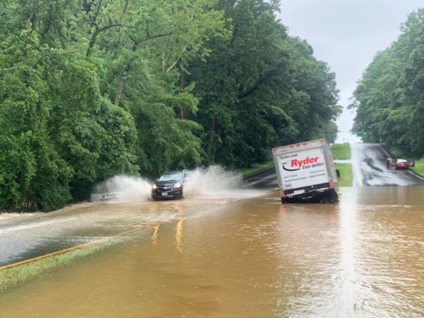
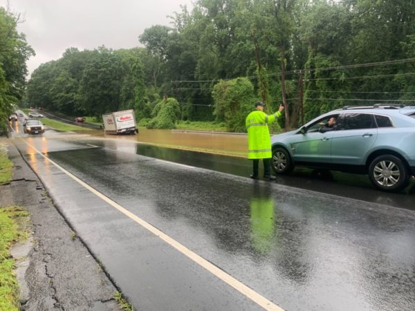
A Severe Thunderstorm Watch is now in effect for Fairfax County.
The National Weather Service issued the watch at 3 p.m. today (Tuesday). It will last until 9 p.m.
Forecasters say stray thunderstorms and showers are possible for the Tysons area.
A Severe Thunderstorm Watch (in pink) is in effect until 9 PM for most of our forecast area for the potential for damaging thunderstorm. Primary threats will be damaging winds and large hail. pic.twitter.com/PoSu9vIjcT
— NWS Baltimore-Washington (@NWS_BaltWash) August 20, 2019
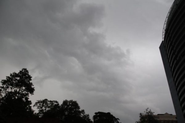
File photo
The Tysons area, including McLean, Vienna and Falls Church, is under a Severe Thunderstorm Warning as an intense storm rolls through the area.
More from the National Weather Service:
…A SEVERE THUNDERSTORM WARNING REMAINS IN EFFECT UNTIL 1130 PM EDT FOR THE WEST CENTRAL DISTRICT OF COLUMBIA…SOUTH CENTRAL MONTGOMERY…NORTHWESTERN ARLINGTON AND NORTHEASTERN FAIRFAX COUNTIES…THE SOUTHEASTERN CITY OF FAIRFAX AND THE CITY OF FALLS CHURCH… AT 1108 PM EDT, A SEVERE THUNDERSTORM WAS LOCATED OVER MERRIFIELD, OR OVER MANTUA, MOVING EAST AT 5 MPH. HAZARD…60 MPH WIND GUSTS AND QUARTER SIZE HAIL. SOURCE…RADAR INDICATED. IMPACT…DAMAGING WINDS WILL CAUSE SOME TREES AND LARGE BRANCHES TO FALL. THIS COULD INJURE THOSE OUTDOORS, AS WELL AS DAMAGE HOMES AND VEHICLES. ROADWAYS MAY BECOME BLOCKED BY DOWNED TREES. LOCALIZED POWER OUTAGES ARE POSSIBLE. UNSECURED LIGHT OBJECTS MAY BECOME PROJECTILES. LOCATIONS IMPACTED INCLUDE… ARLINGTON, BETHESDA, ANNANDALE, VIENNA, FALLS CHURCH, MANTUA, PIMMIT HILLS, AMERICAN LEGION BRIDGE, MCLEAN, POTOMAC, NORTH BETHESDA, TYSONS CORNER, MERRIFIELD, LAKE BARCROFT, CHEVY CHASE, SOUTH KENSINGTON, FOREST GLEN, NORTH CHEVY CHASE, I66 AND I495 INTERCHANGE AND FRIENDSHIP VILLAGE. PRECAUTIONARY/PREPAREDNESS ACTIONS… FOR YOUR PROTECTION MOVE TO AN INTERIOR ROOM ON THE LOWEST FLOOR OF A BUILDING. && HAIL…1.00IN WIND…60MPH
Severe Thunderstorm Warning continues for Bethesda MD, McLean VA, Annandale VA until 11:30 PM EDT pic.twitter.com/qKE7AWaPqd
— NWS Severe Tstorm (@NWSSevereTstorm) August 20, 2019
Updated at 4:25 p.m. — Fairfax County is now under a Flood Warning.
Earlier: Fairfax County and surrounding areas could see some major thunderstorms and damaging winds this afternoon (Thursday).
The National Weather Service recently issued a Severe Thunderstorm Warning that will last until 4 p.m.
More from the National Weather Service:
Until 400 PM EDT.
* At 316 PM EDT, a severe thunderstorm was located over Chantilly, or near Centreville, moving southeast at 15 mph.
HAZARD…60 mph wind gusts.
SOURCE…Radar indicated.
IMPACT…Damaging winds will cause some trees and large branches to fall. This could injure those outdoors, as well as damage homes and vehicles. Roadways may become blocked by downed trees. Localized power outages are possible. Unsecured light objects may become projectiles.
Severe Thunderstorm Warning including Ashburn VA, Sterling VA, South Riding VA until 3:30 PM EDT pic.twitter.com/0wkWMqlwh7
— NWS Baltimore-Washington (@NWS_BaltWash) August 15, 2019
A Severe Thunderstorm Warning is in effect for #FairfaxCounty! Remember, when thunder roars, go indoors! Wait 30 minutes after storm before going back outside! #SafeFairfax #FCFRD pic.twitter.com/BtLpAUl5bQ
— Fairfax County Fire/Rescue (@ffxfirerescue) August 15, 2019
Update at 3:25 p.m. — A Severe Thunderstorm Warning has just been issued and is in effect through 4:15 p.m.
More from the National Weather Service:
THE NATIONAL WEATHER SERVICE IN STERLING VIRGINIA HAS ISSUED A
* SEVERE THUNDERSTORM WARNING…
* UNTIL 415 PM EDT.
* AT 324 PM EDT, A SEVERE THUNDERSTORM WAS LOCATED NEAR BULL RUN, OR NEAR CENTREVILLE, MOVING EAST AT 25 MPH.
HAZARD…60 MPH WIND GUSTS AND QUARTER SIZE HAIL.
SOURCE…RADAR INDICATED.
IMPACT…DAMAGING WINDS WILL CAUSE SOME TREES AND LARGE BRANCHES TO FALL. THIS COULD INJURE THOSE OUTDOORS, AS WELL AS DAMAGE HOMES AND VEHICLES. ROADWAYS MAY BECOME BLOCKED BY DOWNED TREES. LOCALIZED POWER OUTAGES ARE POSSIBLE. UNSECURED LIGHT OBJECTS MAY BECOME PROJECTILES.
* LOCATIONS IMPACTED INCLUDE… ARLINGTON, ALEXANDRIA, CENTREVILLE, RESTON, ANNANDALE, SPRINGFIELD, SOUTH RIDING, HERNDON, FAIRFAX, VIENNA, FALLS CHURCH, MANTUA, PIMMIT HILLS, AMERICAN LEGION BRIDGE, MCLEAN, POTOMAC, BURKE, LINTON HALL, OAKTON AND CHANTILLY.
PRECAUTIONARY/PREPAREDNESS ACTIONS…
FOR YOUR PROTECTION MOVE TO AN INTERIOR ROOM ON THE LOWEST FLOOR OF A BUILDING.
Severe Thunderstorm Warning including Centreville VA, Reston VA, McLean VA until 4:15 PM EDT pic.twitter.com/lK3sIwKTX3
— NWS Baltimore-Washington (@NWS_BaltWash) August 7, 2019
Earlier: Fairfax County is under a Severe Thunderstorm Watch until 8 p.m. this evening (Wednesday).
The watch went into effect around 2 p.m. today and the National Weather Service warns of heavy rain, hail and potentially damaging winds.
According to the National Weather Service:
A SEVERE THUNDERSTORM WATCH IS IN EFFECT UNTIL 8 PM FOR THE ENTIRE AREA. SHOWERS AND THUNDERSTORMS ARE LIKELY THIS AFTERNOON INTO THIS EVENING. SOME THUNDERSTORMS MAY BE SEVERE, WITH DAMAGING WIND GUSTS AND LARGE HAIL BEING THE PRIMARY THREATS.
LOCALLY HEAVY RAIN COULD ALSO CAUSE AN ISOLATED INCIDENT OF FLOODING, MAINLY IN THE BALTIMORE-WASHINGTON METROPOLITAN AREA AND LOCATIONS THAT HAVE RECENTLY RECEIVED HEAVY RAIN.
A Severe Thunderstorm Watch is in effect for areas in red (including the Baltimore and Washington metro areas) until 8 PM today. Storms may produce damaging winds and large hail. Find shelter if warnings are issued or threatening weather approaches. pic.twitter.com/8elR0p5k1o
— NWS Baltimore-Washington (@NWS_BaltWash) August 7, 2019
File photo
Update at 2:50 p.m. — The National Weather Service has issued a Severe Thunderstorm Warning for portions of McLean, Vienna and Tysons.
More from NWS:
THE NATIONAL WEATHER SERVICE IN STERLING VIRGINIA HAS ISSUED A
* SEVERE THUNDERSTORM WARNING FOR… THE NORTHWESTERN DISTRICT OF COLUMBIA… SOUTHEASTERN MONTGOMERY COUNTY IN CENTRAL MARYLAND… NORTHWESTERN PRINCE GEORGES COUNTY IN CENTRAL MARYLAND… EAST CENTRAL LOUDOUN COUNTY IN NORTHERN VIRGINIA… NORTHEASTERN FAIRFAX COUNTY IN NORTHERN VIRGINIA…
* UNTIL 330 PM EDT.
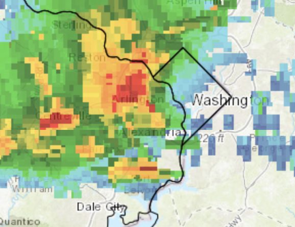
* AT 244 PM EDT, A SEVERE THUNDERSTORM WAS LOCATED OVER RESTON, MOVING EAST AT 25 MPH.
HAZARD…60 MPH WIND GUSTS.
SOURCE…RADAR INDICATED.
IMPACT…DAMAGING WINDS WILL CAUSE SOME TREES AND LARGE BRANCHES TO FALL. THIS COULD INJURE THOSE OUTDOORS, AS WELL AS DAMAGE HOMES AND VEHICLES. ROADWAYS MAY BECOME BLOCKED BY DOWNED TREES. LOCALIZED POWER OUTAGES ARE POSSIBLE. UNSECURED LIGHT OBJECTS MAY BECOME PROJECTILES.
* LOCATIONS IMPACTED INCLUDE… ROCKVILLE, BETHESDA, GAITHERSBURG, RESTON, OLNEY, HERNDON, LANGLEY PARK, VIENNA, LOWES ISLAND, MCLEAN, AMERICAN LEGION BRIDGE, ASPEN HILL, POTOMAC, NORTH BETHESDA, OAKTON, STERLING, NORTH POTOMAC, TYSONS CORNER, HYATTSVILLE AND WHITE OAK.
PRECAUTIONARY/PREPAREDNESS ACTIONS…
FOR YOUR PROTECTION MOVE TO AN INTERIOR ROOM ON THE LOWEST FLOOR OF A BUILDING.
Severe Thunderstorm Warning including Silver Spring MD, Rockville MD, Bethesda MD until 3:30 PM EDT pic.twitter.com/ijRuDDuZlF
— NWS Baltimore-Washington (@NWS_BaltWash) July 22, 2019
Earlier: Fairfax County and surrounding areas could see some thunderstorms, flash flooding, rain and strong wind today (Monday).
The National Weather Service recently issued a Severe Thunderstorm Watch that will go into effect at 10 p.m. — possibly overlapping with the Flash Flood Watch, which begins at 3 p.m. and lasts until “late tonight.”
The county can expect heavy rain around 1-2 inches that could cause flash flooding later this afternoon and tonight. Strong thunderstorms may hit northwestern Fairfax County, with gusts up to 50 miles per hour.
The National Weather Service also issued a Special Weather Statement:
…SEVERE THUNDERSTORMS POSSIBLE THIS AFTERNOON AND EVENING…
A cold front approaching the region will interact with an unstable airmass to result in showers and thunderstorms. Some of these thunderstorms may become severe, especially between 2 PM this afternoon and 9 PM this evening.
The main threats with these storms will be:
* Damaging wind gusts
* Heavy rainfall and flash flooding
* Frequent lightningTake time today to review your severe weather action plan. Have a way to receive alerts from the National Weather Service, and be ready to seek safe shelter should storms approach your neighborhood or a warning is issued.
⛈ A cold front is bringing the heat wave to an end, but not without the threat of severe thunderstorms. A Severe Thunderstorm Watch has been issued until 10 pm. Stay weather aware and be ready to move inside if a warning is issued. #VaWx pic.twitter.com/bLN448GToT
— Ready Fairfax (@ReadyFairfax) July 22, 2019
A Flash Flood Watch is in effect for most areas this afternoon through late tonight. Severe thunderstorms are possible this afternoon and evening. See map for more details. pic.twitter.com/Na8nVWgm7u
— NWS Baltimore-Washington (@NWS_BaltWash) July 22, 2019
Stormy Afternoon Ahead With Flash Flood Watch — The National Weather Service issued a Flash Flood Watch for today (Monday) for Fairfax County and surrounding areas from 3 p.m. through late tonight. Thunderstorms and heavy rainfall totaling 1-2 inches are expected. “Much of this rain may fall in short periods of time in any one given location, resulting in the risk for flash flooding this afternoon and tonight.” [NWS]
Georgetown Pike Now Open Again — All lanes of Georgetown Pike (Route 193) between Centrillion Drive and Georgetown Ridge Court in McLean closed for emergency road repairs on Sunday following a fallen tree and wires. The road reopened several hours later. [Twitter]
New Field in Tysons — “Quantum Field officially opened [earlier in July] and players will soon get the chance to enjoy this lighted, state-of-the-art synthetic turf rectangular field.” [Connection Newspapers]
Firefighters Fought Tysons Fire — Firefighters responded to a small fire on roof in the 8600 block of Westwood Center Drive in Tysons West on Sunday. [Twitter]
Langley High School Students Lauded — “Five local high-school students recently received the McLean Citizens Association’s 2019 Outstanding Teen Character Awards for their dedication to the community.” [Inside NoVa]
McLean Resident Lands Federal Agency Role — “The US Senate June 27 voted to confirm Aimee Jorjani as the first full-time chairman of the Advisory Council on Historic Preservation.” Jorjani is a McLean resident. [Connection Newspapers]
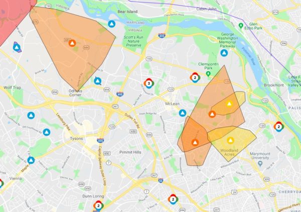
Roughly 4,000 people in McLean have lost power this evening (Wednesday) right after a storm hit the area.
A Dominion Energy map shows five major power outages. One is west of I-495 above Odricks Corner that is affecting 1,076 customers.
The other four are around Old Dominion Road in the Chesterbrook area — the largest of which was caused by a circuit outage and is impacting 1,237 people, according to the map.
Investigations are pending for the three others ones, which, in total, have left a little more than 2,000 people in the dark.
Dominion Energy does not yet have estimated times for when the power will be restored for the outages.
Several smaller outages affecting 14 people or less are scattered throughout McLean, Vienna, Tysons, Falls Church and Merrifield.
The outages popped up on the map shortly after the National Weather Service issued a Severe Thunderstorm Watch, followed by a storm that quickly passed through the Tysons area shortly after 5 p.m.
Map via Dominion Energy
A little more than a week ago, severe flash flooding swept the Tysons area causing widespread damage.
Tysons Reporter reported on a variety of the storm’s impacts from multiple road closures to swift water rescues, from to flooded yards, basements and fields to missing chickens in McLean.
While the recent hot weather dried out the Tysons area, we want to know how much the flooding impacted you.
Let us know in the poll and comment below to tell Tysons Reporter more about your experience.
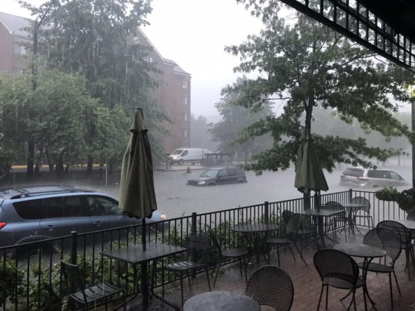
First photo via @SteveML9022/Twitter
(Updated at 11:45 a.m. 7/19/19) Fairfax County declared a local emergency as it seeks federal disaster aid to help with flash flooding damage.
In a board matter approved at the Board of Supervisors meeting today (Tuesday), Dranesville District Supervisor John Foust said, “The McLean-Falls Church area was particularly hard hit. Today, more than a week later, there are roads in the county that remain closed with no estimated date for reopening.”
The flooding caused extensive disruption to the area from water rescues to road closures last week.
The region experienced about one month’s worth of rain, making it the heaviest one-hour total rainfall since at least 1936, according to the Washington Post. The City of Falls Church and Arlington County both declared a state of emergency just days after the storm.
More from a copy of the board matter that Tysons Reporter received:
Fortunately, despite the intensity of the storm, no one was severely injured or worse. The Office of Emergency Management and the county’s public safety and public works staffs were great! I commend them for reacting promptly and very professionally to emergencies that occurred throughout the county.
Since the storm, my office has received dozens of emails and phone calls from residents who experienced devastating damage to their property. Many residents had several feet of water and mud in their basements. Others experienced even worse damage. Some residents have estimated the cost to repair the damage will be as high as six figures.
The Office of Emergency Management has asked residents and businesses to file damage reports so that the county can evaluate whether we will pursue federal disaster aid… [Residents] are anxiously inquiring whether Fairfax County will do the same. They also need to know what federal aid might be available to them if a federal disaster is declared.
Residents are also learning that their property insurance may not cover their damages. Some residents believe that a lack of adequate infrastructure to convey some or all the stormwater contributed to the damage they suffered. Some have inquired about filing potential claims against the county and/or the Virginia Department of Transportation.
Now, County Executive Bryan Hill will need to let the board know about the status and timing for determining whether or not the county will receive federal disaster aid after the county retroactively declared a local emergency.
“Many asked why we didn’t do a declaration the day after the storm like Arlington,” Hill said.
Hill said that he had several conversations with Foust about the process and that meetings are scheduled with the county’s stormwater management crew. “We will probably need to change how we do our engineering going forward,” Hill said.
The county’s Emergency Management Coordinator Seamus Mooney is set to update the county in the last week of July, Hill said.
Additionally, Foust’s board matter directed the county to create an informational flyer or brochure about how residents can submit damage claims to the county and the Virginia Department of Transportation, along with a list of county services and resources that could assist residents experiencing storm damage.
Chairman Sharon Bulova said that it’s also important to push information on social media on what people should report and why.
“We will likely have additional storm and water events in the future,” Bulova said, adding, “We’ve gotten really good at snow and not so much with water.”
After major flash flooding caused widespread damage on Monday (July 8), Dranesville District Supervisor John Foust shared how the county can better prepare for future storms and what steps are currently underway.
“It was horrific in certain areas,” Foust said. “It came by and went so fast.”
Foust said that while he wasn’t surprised by the damage from the flash flooding on Monday, it was the worst he has ever seen in Fairfax County.
Tysons Reporter talked to Foust about how work after the storm has been going around the Tysons area and what infrastructure improvements are needed to help the county weather the next big storm.
When the flooding started, Foust said he was inside his home during the brunt of the storm, waiting to get to his car parked outside. Eventually, Foust said he was able to get outside and drive to his office, which is nearby — “Pretty easy compared to what many had to go through,” he said.
Assessing the Damage
From a multitude of road closures to flooded backyards, from more than 55 water rescues to three missing chickens swept away, clean-up and assessment are still underway across the county.
In an email to residents last night (Wednesday), Foust urged people affected by the storm to submit information online to a disaster damage database to help the county with its damage assessment. People can submit reports until Wednesday, July 24.
“While owners are responsible for repairs on their property, the county could use this data to pursue disaster aid through the federal government to the extent such aid is available,” Foust wrote.
The Town of Vienna also tweeted about the database, writing, “Damage reports may impact what — if any– federal disaster assistance may be made available.”
As for the cleanup efforts this week, Foust said, “The county staff performed extremely well.”
Foust also praised the county’s work on stream restoration, which recently included Bull Neck Run and Dead Run Stream.
Road Work Underway
Foust said that several improvement projects are slated to help roads weather serious flooding in the future, including Tucker Avenue and Chesterbrook Road in McLean.
The Tucker Avenue project will address flooding along the avenue from Birch Street to where it deadends at the Pimmit Run stream. Project design is set to start this summer, he said.
“It’s almost scary what happens on that road when it rains hard,” he said because of the road’s incline may make it the worst road for flooding in the McLean District. “Not a meandering stream but a roaring river.”
The Chesterbrook project at the intersection of Chesterbrook Road and N. Albemarle Street is set to add a larger pipe for more water. While the Virginia Department of Transportation had said that the project may start in the fall, plans have not been finalized, he said.
In addition to the work on those local roads, Fouse said that the Route 7 widening project includes elevating the road where Dead Run Stream regularly floods Route 7.
Preparing for the Next Big Flood
Going forward, “a lot of things need to be done,” Foust said to minimize damage from another major storm.
McLean and the general area around Tysons were built before stormwater management requirements, which the county is now trying to superimpose with a new system, he said.
Foust said that as changing weather patterns could see severity increase for future storms, he wants the county to prioritize funding stormwater management projects and work with developers of infill projects, which develops vacant or under-used areas within existing urban areas, to better manage stormwater sites.
“The funding is never adequate,” Foust said Capital Improvement Program funding for stormwater management projects. “You do the best you can with the resources you have. For available resources, we need to prioritize stormwater management projects more than in the past.”
Whenever the next big flash flooding hits, Foust said that he hopes for more notice from forecasters.
“It’s one thing when you see it coming,” he said.


