")
Fairfax County Recognizes 9/11 Anniversary — For those who missed it, watch the remembrance ceremony that Fairfax County held on Saturday (Sept. 11) to mark 20 years since the 9/11 attacks. The Town of Vienna commemorated the occasion with a ceremony of its own, and the McLean Community Center posted a “Taps” tribute with comments from local faith leaders.
Virginia DMV to Resume Walk-in Services — “Beginning Oct. 5, Virginia Department of Motor Vehicles customers may choose to schedule an appointment for service or opt for walk-in service on alternating days at all 75 customer service centers…During the pandemic, [the] DMV began operating by appointment only as it reopened offices in May 2020 after a temporary closure due to the rapid spread of COVID-19.” [Inside NoVA]
Robbery Reported in Mosaic District — A man told Fairfax County police on Sept. 4 that an acquaintance had assaulted him and taken his property in the 2900 block of District Avenue in Merrifield. Police arrested the suspect, who fled the scene of the assault, on Sept. 7 and charged him with robbery and malicious wounding. The victim went to a hospital with non-life-threatening injuries. [FCPD]
Lee Highway Renaming Task Force Meets Tonight — The Confederate Names Task Force appointed to determine whether Fairfax County should rename Lee Highway (Route 29) and Lee-Jackson Memorial Highway (Route 50) will hold its second meeting at 7 p.m. today (Monday). The meeting will be virtual and can be followed online, on Channel 16, or by phone at 703-324-5300. [Fairfax County Government/Twitter]
")
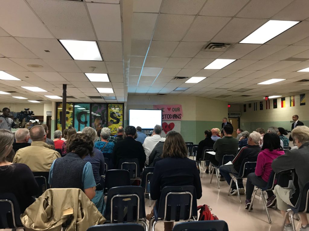
(Updated at 9:10 a.m. on 7/15/2021) Fairfax County is convening a “Confederate Names Task Force” specifically charged with making a recommendation about renaming the county’s portions of Lee Highway and Lee-Jackson Memorial Highway.
The Board of Supervisors approved the appointment of the 30-member task force on Tuesday (July 13).
The task force’s mission is to review the names of Lee Highway (Route 29) and Lee-Jackson Memorial Highway (Route 50) to determine if the roads should be renamed and, if so, what the names should be. A county-appointed facilitator will also work with the task force.
The roadways currently bear the monikers of Confederate generals Robert E. Lee and Thomas “Stonewall” Jackson.
This is a direct result of the work done by the county’s history commission to identify and inventory every place in the county named after a Confederate. The 539-page report noted that there were about 157 streets, parks, monuments, subdivisions, and public places in the county bearing names with ties to the Confederacy.
The most prominent were Lee Highway, about 14 miles of which runs through the county around Merrifield, Fairfax, and Centreville, and Lee-Jackson Memorial Highway. About 8.5 miles of that roadway runs through the county, including Chantilly and near Fair Oaks Mall.
")
“In Fairfax County, our diversity is our greatest strength and it’s important that we honor and celebrate that diversity,” Board of Supervisors Chairman Jeff McKay said in the press release. “We cannot ignore what the Lee and Lee Jackson Memorial Highway names represent in our community and especially to our African American neighbors. The Confederate Names Task Force, which includes a diverse group, will examine and make recommendations on how both roadways can better reflect our values as we chart a positive path together for the future.”
The task force will meet monthly, starting later this month or early August, according to the agenda for the board meeting. The meetings will be open to the public, and the task force will seek input from the public prior to making a decision.
The group is expected to provide a recommendation to the county board by “the end of calendar year 2021.”
The task force is chaired by Sully District Planning Commissioner Evelyn Spain, who will be joined by 29 other members, including historians, civic organization leaders, homeowners’ association members, residents, professors, and faith leaders.
Spain says reevaluating the use of Confederate street and place names is necessary if Fairfax County wants to be inclusive and respectful of its increasingly diverse population.
“Naming highways after Robert E. Lee and Stonewall Jackson celebrates men who fought a war against the United States to perpetuate slavery,” Spain said in a statement. “One Fairfax requires us to look at these issues through an equity lens to understand how these names have negatively impacted our community and people of color as well as how Confederate names adversely impacts them today…I’m honored to be a part of the Confederate Names Task Force as we work toward building a more inclusive and equitable Fairfax County.”
If the task force recommends changing the names of the roads, the county will have to undergo a somewhat complicated process to actually make it happen — much like it was when Arlington renamed its portion of Route 29 and Alexandria renamed Route 1, which had been named after Confederate President Jefferson Davis.
If changes are recommended, the task force would need to provide two to five alternate names for each road. Then, the county board and task force will hold at least one public hearing to allow for comment about the potential change.
After the public hearings, the board will then vote on whether to take the task force’s recommendation. A timeline laid out back in May projected that could happen in early 2022.
If the board votes to change the highway names, it would then submit a resolution to the Commonwealth Transportation Board requesting the changes while also committing to paying for the signage.
If that’s approved by the Commonwealth, the board has to pass a budget item for the cost of the signs, and an interdepartmental working group would set up a timeline for the actual switching out of signs and, finally, officially changing the roads’ names.
The working group will also coordinate with other jurisdictions on their name changes.
A list of possible new names for Lee Highway (Route 29) and Lee-Jackson Memorial Highway (Route 50) could be ready as soon as this December.
On July 13, the Fairfax County Board of Supervisors could approve about 25 members for a task force to examine the possibility of renaming the highways and appoint the group’s chair.
The group would recommend whether to rename those streets and what new names to consider this December. A public hearing and decision could come in early 2022.
“Approximately 30 organizations and individuals have expressed an interest in participating,” Fairfax County Department of Transportation Director Tom Biesiadny said yesterday (Tuesday). “14 organizations and individuals declined to participate.”
This schedule was announced one year after the May 25 death of George Floyd in Minneapolis, which sparked Black Lives Matter protests nationwide. In Fairfax County, the movement prompted the board to consider renaming streets and structures with Confederate names.
Biesiadny and his staff presented their recommendations to the board’s land use policy committee for how to move forward with renaming Route 29 and 50 as well as streets and subdivisions.
“I think the schedule is good and compact,” Board of Supervisors Chairman Jeff McKay said. “If we can get the recommendations by the end of the year, that would be helpful.”
The two thoroughfares are the first locations to be considered for new names after the Fairfax County History Commission compiled a list of street names, monuments and public spaces with Confederate ties.
The group identified more than 26,000 streets and places, which was first narrowed down to 650 well-known Confederate officers and locally-known Confederates and again, down to 150 assets confirmed to have Confederacy-associated names.
Neighboring Loudoun County is establishing a task force to consider renaming Lee-Jackson Memorial Highway, and a group in Arlington County is discussing new names for Lee Highway, Biesiadny said.
Some supervisors urged staff to keep coordinating with Fairfax’s neighbors.
“If it’s possible to be on the same page as Arlington and Loudoun, that’s great,” Braddock District Supervisor James Walkinshaw said. “We shouldn’t be driven by their process, but that seems to be like a viable secondary goal.”
He also suggested the task force develop a naming plan that reduces confusion for local businesses.
“One of the things I have heard from businesses in and around the Kamp Washington intersection is that the status quo is very confusing,” Walkinshaw said.
Route 50 has four names depending on the location, Deputy County Executive Rachel Flynn explained to Tysons Reporter in December.
In Loudoun County, it’s John Mosby Highway, and in Fairfax County, it becomes Lee-Jackson Memorial Highway. Route 50 then becomes Fairfax Boulevard in the City of Fairfax, where it intersects with Route 29, also known as Lee Highway. East of the city, Route 50 turns into Arlington Boulevard once it’s back in Fairfax County. Read More
")
The man who died after a vehicle crash in Merrifield early Monday morning (March 29) was a 49-year-old Centreville resident named Dashdavaa Zambalgarav, the Fairfax County Police Department reported yesterday afternoon.
Police say the crash occurred just before 4 a.m. at the intersection of Arlington Boulevard and Javier Road, and it involved a single vehicle with Zambalgarav as the driver and lone occupant.
Crash reconstruction unit detectives have preliminarily determined that Zambalgarav was traveling west on Route 50 in a 2008 Lexus RX “when he drifted into the center median and crashed into a traffic pole at Javier Road,” according to the police report.
Zambalgarav was transported to a hospital, where he died from his injuries.
“Detectives continue to investigate the circumstances surrounding this crash, but preliminary, do not believe speed or alcohol were factors,” the FCPD said.
Since the investigation is ongoing, police are still seeking additional information about the crash:
Anyone with information about this crash is asked to contact our Crash Reconstruction Unit at 703-280-0543. Tips can also be submitted anonymously through Crime Solvers by phone – 1-866-411-TIPS (866-411-8477), by text – Type “FCCS” plus tip to 847411, and by web – Click HERE. Download our Mobile tip411 App “Fairfax Co Crime Solvers”. Anonymous tipsters are eligible for cash rewards of $100 to $1,000 dollars if their information leads to an arrest.
Image via Google Maps
")
Fairfax County police are investigating a fatal crash in Merrifield that happened early this morning (Monday).
The crash occurred at the intersection of Route 50 (Arlington Boulevard) and Javier Road. It involved a single vehicle with one occupant, a man who was taken to the hospital, where he later died, according to the Fairfax County Police Department.
Police closed westbound Arlington Boulevard between Javier Road and Williams Drive so that detectives from FCPD’s crash reconstruction unit could investigate the incident.
The investigation remains ongoing, but Arlington Boulevard reopened around 8:22 a.m.
Detectives continue to investigate this crash. Arlington Blvd is now open. Follow our blog, https://t.co/PBMfNnRMp0 for further updates. https://t.co/bMQgQ23xvQ
— Fairfax County Police (@FairfaxCountyPD) March 29, 2021
")
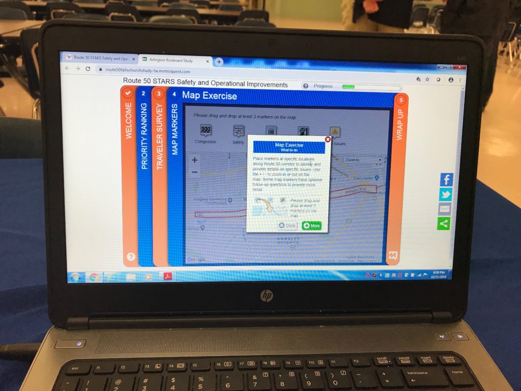
The Virginia Department of Transportation is now soliciting public input on its draft proposals for potential safety and operational improvements on Route 50 until Oct. 30.
The Route 50 Strategically Targeted Affordable Roadway Solutions (STARS) study centers on the three miles of Arlington Boulevard between Jaguar Trail and Wilson Boulevard (Route 613) in the Falls Church area of Fairfax County.
Released in an online presentation on Oct. 13, the proposed improvements include:
- Pedestrian enhancements at Jaguar, Allen Street, Graham Road, Woodlawn Avenue, Annandale Road, the area between Marshall Street and East Tripps Run Road, and the Thomas Jefferson Library area
- Turn lane improvements at Allen, Graham, and South Street
- Access management improvements throughout the corridor, including a widened median in the Thomas Jefferson Library area, and extended medians at Allen, Graham, Annandale, and the area between Marshall and East Tripps Run
VDOT says its proposed improvements are primarily designed to reduce pedestrian crashes and improve safety without making significant changes to the roadway. Possible costs range from $2.5 million to $12 million depending on whether they would require any construction.
")
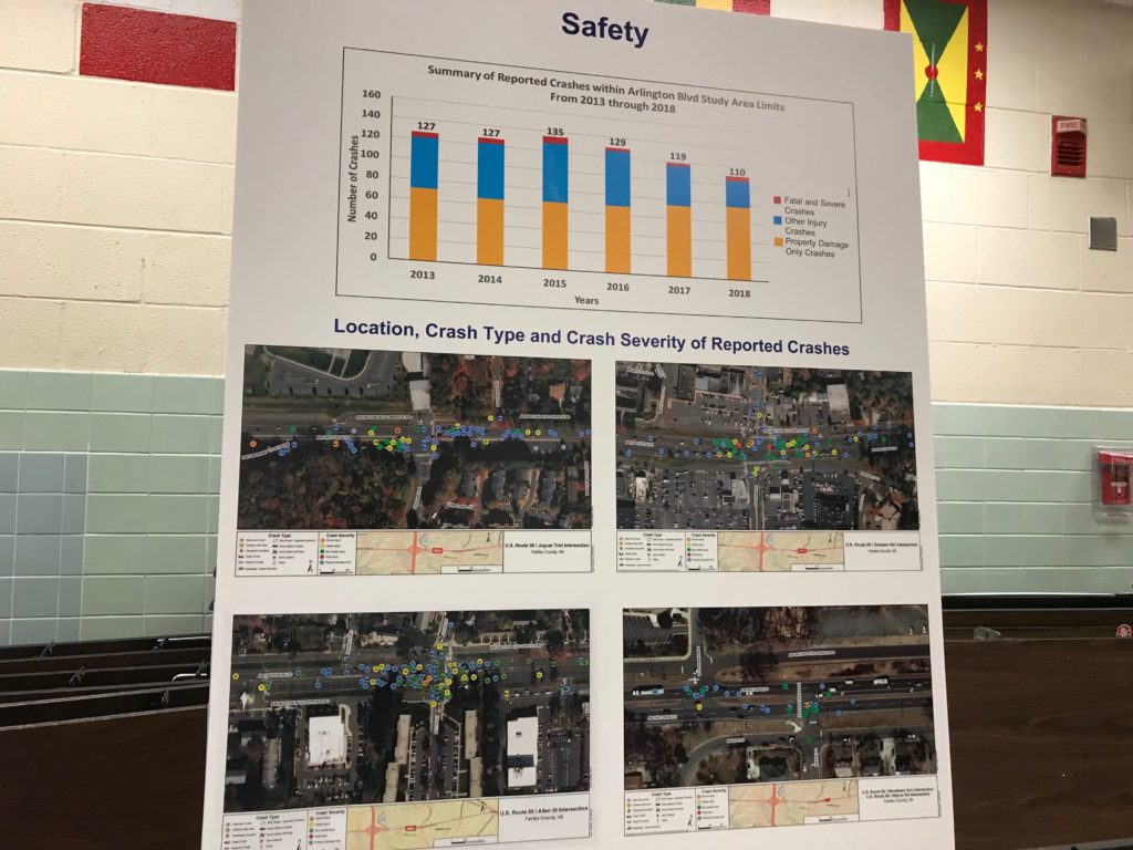
VDOT launched the Route 50 STARS study back in June 2019 and held a public information meeting on Oct. 21, 2019. An online survey conducted last October drew 962 participants, who identified traffic congestion, pedestrian safety, and travel time reliability as their top three issues with Route 50.
According to VDOT, Route 50 sees over 50,000 vehicles a day on average, and drivers often experience delays during peak hours, especially at the Graham Road and Annandale Road intersections. It also features 10 pedestrian crosswalks and 12 bus stops, while accommodating 60 Metro buses per day during the work week.
The annual crash rate on Route 50 is 32% to 43% higher than the average rate for the other primary highways in Northern Virginia.
“While they were not a large percentage of the reported crashes, pedestrian crashes accounted for many of the fatal crashes and severe-injury crashes in the corridor,” VDOT said in its video presentation.
VDOT had planned to present its initial draft recommendations this past spring, but limitations on large in-person meetings during the COVID-19 pandemic led the department to delay the presentation and deliver it virtually instead.
Community members can provide input on the recommendations by taking an online survey or sending comments to VDOT by email at [email protected]. They can also be mailed to VDOT traffic engineer Bobby Mangalath at 4975 Alliance Drive, Fairfax, VA 22030.
A report with the study’s final recommendations is expected to be released this coming winter.
VDOT emphasizes that the purpose of the study, which has a cost of $280,000, is to give Fairfax County options to consider when making funding requests and developing its comprehensive plan, but no decisions will be made on which projects, if any, will be implemented.
Staff photo by Catherine Moran, image via VDOT
")
Fairfax County police say a man was arrested in connection to a fatal hit and run on Arlington Blvd (Route 50) in the Falls Church area last January.
Police said a pickup truck struck and killed 93-year-old Pericles Apostolou, from Falls Church, when he was crossing Arlington Blvd outside of the crosswalk near Summerfield Road around 6 p.m. on Jan. 18, 2019, police said.
“The truck did not stop and drove away from the scene,” police said last year.
FCPD announced today (Wednesday) that 30-year-old Michael Smith, of Fredericksburg, has been charged with felony hit-and-run.
“Detectives from our Crash Reconstruction Unit worked extensively to identify the suspect,” according to a press release. “Through their investigative leads and tips received from the community, Smith was identified and arrested by Manassas City Police on Feb. 6.”
Smith is currently being held at the Fairfax County Adult Detention Center with no bond, according to police.
Police said they are also working on three unsolved, fatal hit and run cases from 2018 and 2019, which includes one on Leesburg Pike near I-495 last February. Police are asking that anyone with information about this case or the other three to contact them at 703-280-0543.
Map via Google Maps
")
The Falls Church Anglican built a new church along Route 50 in the Falls Church area after losing its former sanctuary space.
The new location (6565 Arlington Blvd) is nearly complete and began holding services in September, Zach Kincaid, the church’s spokesperson, said. Now they are looking to finish certain cosmetic projects around the church, including landscaping and interior design.
The Anglican Church built a new space because they lost their original sanctuary (115 E. Fairfax Street) in a legal battle when they split from the Episcopal Church due to political and religious differences. The Episcopal Church declined to comment.
The new church cost around $16 million, which came from contributions by the congregation and parishioners, Kincaid said.
Before deciding on the Falls Church spot along Route 50, they considered following other parishes that built churches in Loudoun County, where real estate is less expensive, Kincaid.
“The glue that stuck us to something around here was to be part of this neighborhood still,” he said. “It was a fleeting thought.”
In total, the new space consists of 16,000 square feet of space divided between two stories, Kincaid said. About 6,000 square feet will be used for a gathering space for children and family, while the remainder will be worship space.
The church has around 900 chairs but typically seats around 1,200 worshipers each Sunday, Kincaid said.
“Lots of people tend to turn their attention to church as Advent comes up,” he said, explaining that membership and attendance tend to increase around Christmas time.
To engage with the surrounding community, the church invited surrounding neighborhoods to stop by for open houses.
The church shares an office space next door with other professions, such as doctors.
Renovations should be completed soon, Kincaid said, but they currently do not have an exact date. The church is finishing up the permit process with Fairfax County.
Photo courtesy Craig Thoburn
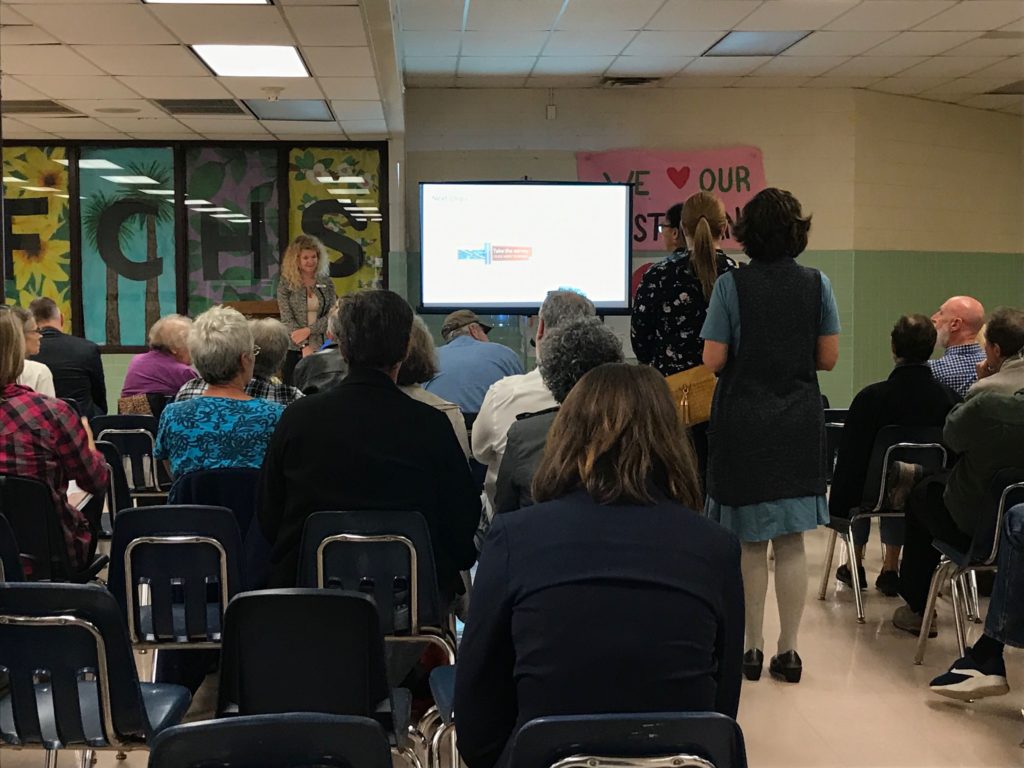
Commuters and residents want to see more bicycle and pedestrian safety improvements along Route 50 in the Falls Church area.
At a meeting hosted by the Virginia Department of Transportation (VDOT) last night, VDOT officials and residents discussed different ideas for improving the route, which has up to 51,000 vehicles travel daily, according to VDOT.
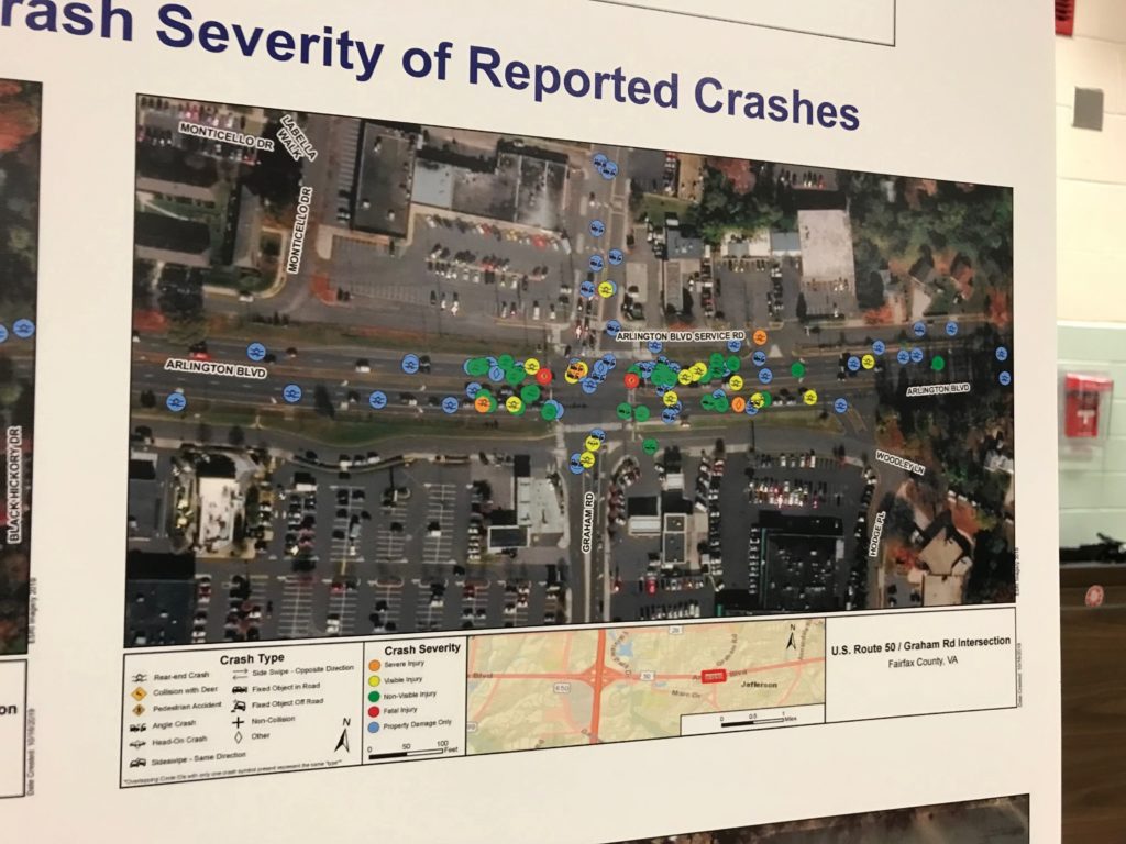
The meeting coincidentally happened a day after a 40-year-old man was struck and killed at the intersection of Route 50 and Graham Road. On a map of reported crashes since 2013, that intersection had two reports of fatal crashes, along with dozens of other crashes ranging in severity from property damage to serious injuries.
A study is underway to evaluate potential safety and operational changes for three miles of Route 50 between Jaguar Trail and Wilson Blvd.
VDOT officials said that the study is looking at data showing crash hotspots, speed and traffic count from January 2013 to the spring of 2019 and projections out to 2030.
“We don’t go into a study with the solutions already in hand,” Allison Richter, the liaison for Fairfax and Arlington counties, said.
The possible improvements VDOT is looking at include:
- traffic signal timing/operations
- turn lane
- turn restrictions
- access management
- pedestrian enhancements
- “innovative intersections“
Richter said that bike and pedestrian safety improvements are under consideration.
About 50 people showed up for the meeting, including Fairfax County police, Mason District Supervisor Penny Gross, School Board Member Dalia Palchik and Tom Biesiadny, the director of Fairfax County’s transportation department.
Many of the people who lined up to provide feedback to VDOT pointed out specific problem areas — urging for time-restricted turn lanes, signal timing changes — and more focus on bicyclists, pedestrians and people using mass public transit.
“This area is becoming more urban over time,” one attendee told VDOT officials, adding that VDOT should focus on safety over speed for drivers.
Added safety measures could include two-way bike lanes on one-way service roads and more lighting, attendees said.
Sonya Breehey, a bike safety advocate, suggested traffic calming on the frontage roads.
“Arlington Blvd scares me,” Breehey said.
A handful of people called for VDOT to lower the speed limit from 45 miles per hour, with one person suggesting a new speed limit of 35 miles per hour.
One man who provided feedback urged VDOT to not forget about drivers, who might face slower speeds and longer travel times.
“Better late to dinner than dead,” someone from the audience shouted after the man finished commenting.
“Please be respectful,” the man responded.
People can take an online survey — which allows respondents to mark problem spots on a map and rank the six possible improvements — and submit comments to Bobby Mangalath, at 4975 Alliance Drive, Fairfax, Va. 22030 by next Thursday, Oct. 31.
VDOT plans to hold another information meeting when the study wraps up in the spring.
")
(Updated at 11:50 a.m.) Fairfax County police have identified the man who was fatally struck by a police cruiser along Route 50 in the Falls Church area yesterday.
Shortly after midnight on Sunday (Oct. 20), a police cruiser struck and killed 40-year-old Carlos Romeo Montoya near Arlington Blvd (Route 50) and Graham Road, police said.
“We do not have a current address at this time,” police said in a press release today. “Next of kin have been notified.”
More from FCPD:
A patrol officer who has more than four years of law enforcement experience and who is assigned to the Mason District Station was driving in a marked police cruiser in the area of Arlington Boulevard and Graham Road. The officer was responding to a call for service for disorderly subjects.
The marked police cruiser was proceeding through a green light eastbound on Arlington Boulevard approaching the intersection of Graham Road.
This intersection has a pedestrian crosswalk with a pedestrian signal for the crosswalk. The posted speed limit for Arlington Boulevard in that area is 45 miles per hour.
As the police cruiser proceeded through the intersection, an adult male was struck in the left travel lane of Arlington Boulevard by the cruiser. The location of impact was within the crosswalk as determined by the police cruiser in-car video.
The officer immediately stopped to render first aid and called for the Fire and Rescue Department. The pedestrian was transported to the hospital by rescue personnel and was pronounced deceased.
“The best information we have right now is that the officer did have a green list, was proceeding through the intersection and that the pedestrian was, unfortunately, crossing against the ‘Don’t walk’ sign,” Chief Edwin Roessler Jr. said during a press conference yesterday.
Montoya’s death marks the 14th pedestrian fatality in the county this year, according to police.
“This is an intersection that has a historical issue with pedestrian safety,” Roessler said at the press conference.
Cyclist and pedestrian advocates are urging people to attend a meeting tonight (Monday) about changes to Route 50.
The Virginia Department of Transportation (VDOT) is looking to get community feedback about a Route 50 study currently underway to identify potential safety and operational changes for Route 50 between Jaguar Trail and Wilson Blvd.
The Fairfax Alliance for Better Bicycling (FABB) took to social media to urge people to attend the meeting.
Bruce Wright, a board member of FABB, said that the Graham Road and Route 50 intersection was identified in 2004 “as a big problem” for pedestrian safety and is “still very dangerous.”
Wright said that service roads along Route 50, the dense residential area nearby and high speed limit contribute to the safety factors at the intersection. Wright said he wants VDOT and the county to consider redesigning the intersection and lowering the speed limit.
“It is such an important corridor and yet it’s optimized for motorists,” Wright said.
FABB is working with local police to identify where bicycle crashes are happening, Wright said, adding that the group wants to work with VDOT as well.
The crash is currently under investigation and is working to determine the cruiser’s speed, the lighting conditions at the intersection and the condition of the pedestrian walk sign, along with a forensic medical examination, police said.
“The results of the investigation by the Crash Reconstruction Unit will be presented to the Office of the Commonwealth’s Attorney for Fairfax County,” the press release said.
Anyone with information about the crash can contact Crash Reconstruction Unit detectives at 703-280-0543.
“The involved officer was reassigned to administrative duties pending the outcome of our investigations by the Crash Reconstruction Unit and the Internal Affairs Bureau,” police said.
Map via Google Maps