")
Starting today, residents and business owners can head to the Tysons-Pimmit Regional Library to seek low-interest loans to help pay for flood damage repairs.
Dranesville District Supervisor John Foust shared in a newsletter to constituents Monday (Aug. 12) information about two loan centers — Tysons-Pimmit Regional Library (7584 Leesburg Pike) and the Arlington County Trades Center (2700 S. Taylor Street).
Gov. Ralph Northam announced last Thursday (Aug. 8) that the U.S. Small Business Administration (SBA) will offer low-interest federal loans to people affected by the July 8 flooding in the City of Falls Church, along with Fairfax and Arlington counties and the City of Alexandria.
Businesses and private nonprofit organizations may borrow up to $2 million, while homeowners may borrow up to $200,000 for damaged or destroyed real estate and up to $40,000 for personal property.
“In addition, the County has waived any permit fees that might apply to reconstruction efforts,” Foust wrote.
More from the newsletter:
The SBA may increase loans by up to 20 percent if officials verify the extent of physical damages. Agency officials also may support efforts by applicants to build storm shelters or safe rooms to protect against damage from a similar natural disaster in the future.
SBA officials will set the loans’ terms and amounts based on applicants’ financial conditions. The agency will offer loans with terms of up to 30 years and interest rates as low as 1.938 percent for renters and homeowners, 2.75 percent for non-profits, and 4 percent for businesses.
The loan center at the Tysons-Pimmit library will be open:
- Tuesday-Thursday, Aug. 13-15: 11 a.m.-8 p.m.
- Friday, Aug. 16: 10 a.m.-6 p.m.
- Saturday, Aug. 17: 1-5 p.m.
- Monday, Aug. 19: 11 a.m.-8 p.m.
The loan center in Arlington will be open the same days and times, except for different hours on Saturday, Aug. 17, from 9 a.m.-1 p.m. Both centers will be closed on Sunday, Aug. 18.
“SBA officials will be available to answer questions about the agency’s disaster-loan programs and help applicants fill out the necessary forms,” Foust wrote in the newsletter.
Residents have until Oct. 7 to request a loan to cover physical property damage, while businesses have until May 7, 2020, to request a loan for economic injury.
Photo via Fairfax County
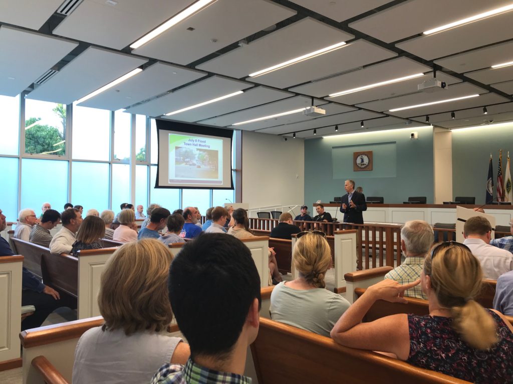
Falls Church city leaders and residents are working together on flood prevention to minimize damage from storms like the one that hit last month.
The City of Falls Church held a meeting to discuss the impact of the severe flash flooding on July 8 with residents Wednesday night (Aug. 7).
The meeting kicked off with a staff presentation to update the roughly 50 people who filled the council chambers.
While City Manager Wyatt Shields said that the city has started some utility improvements, like enlarging the stormwater channel and increasing stormwater detention, the city now needs to shift its focus from water quality to quantity.
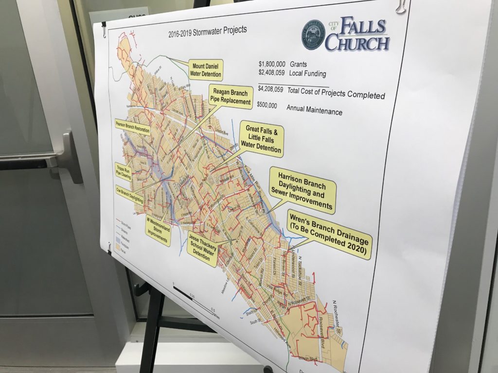
The city’s annual budget has $1.6 million dedicated to stormwater projects, he said.
“This Is Not The First Time”
Mayor David Tartar kicked off the meeting by stressing a need for better flood prevention for possibly more severe flooding in the future.
“It seems like these once in a lifetime events are happening more often,” Tartar told the attendees, adding that the city wants to take a holistic approach to solving city-wide problems.
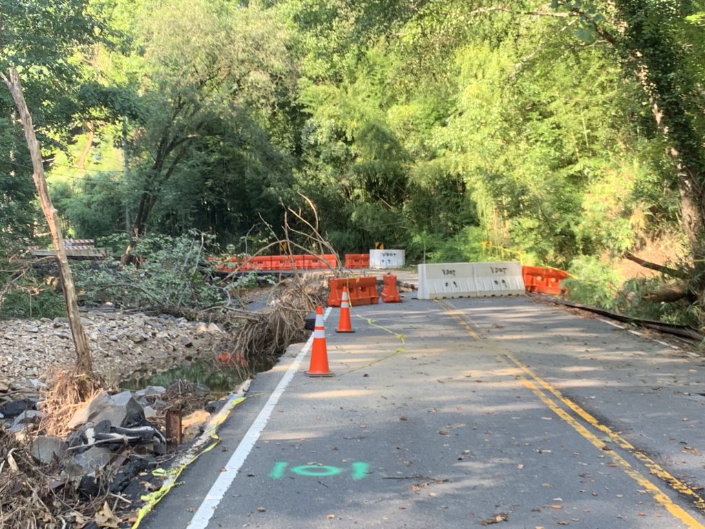
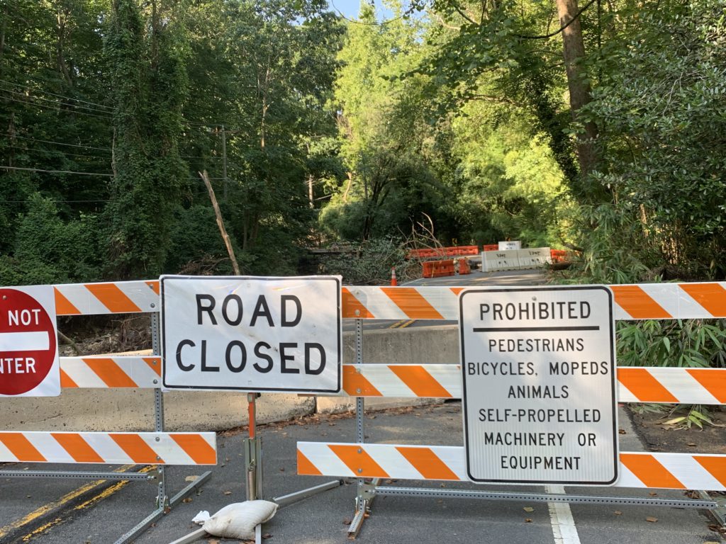
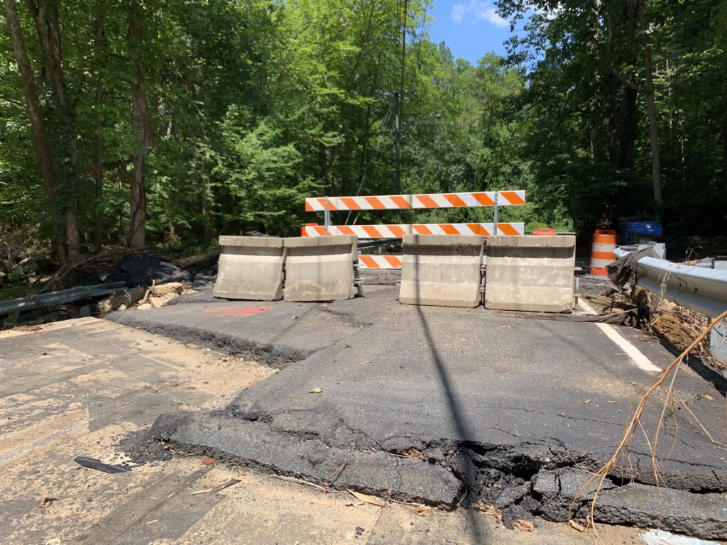
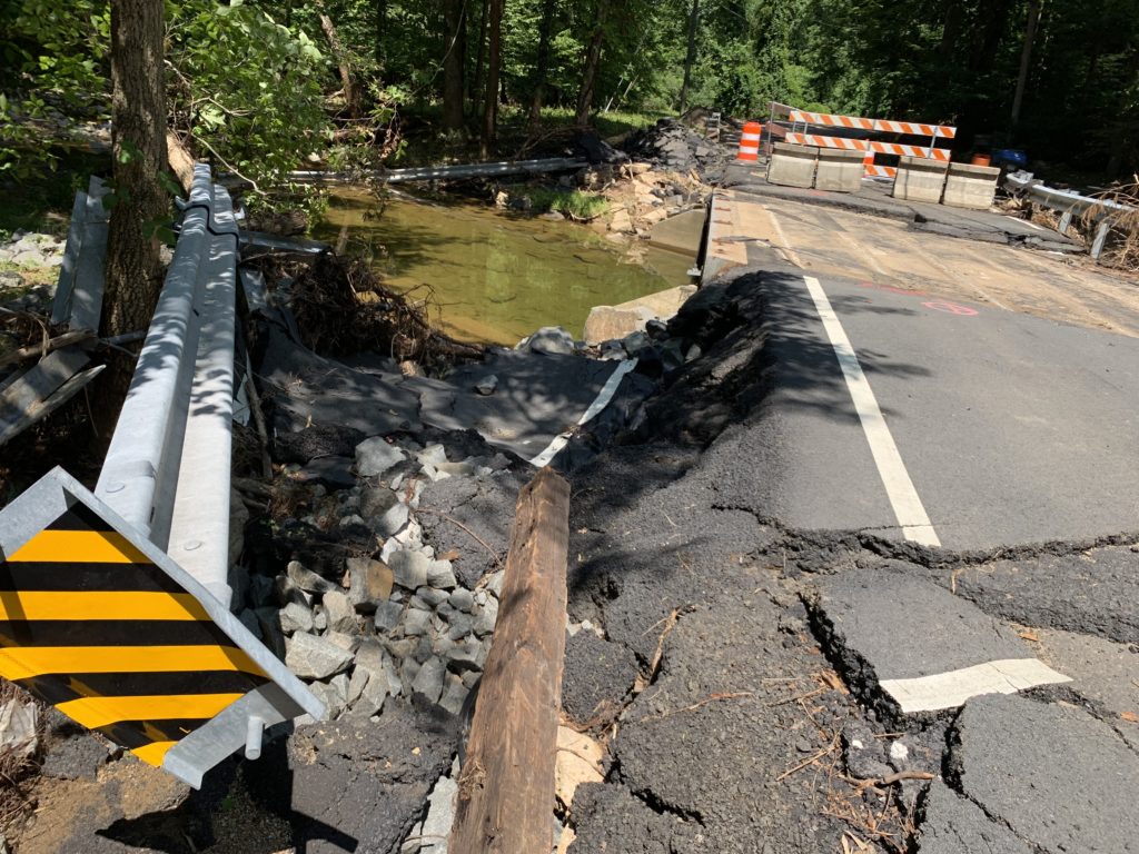
Much of the roads affected by the flash floods two weeks ago have been fixed, but two routes through McLean remain out of commission and will require long term repairs.
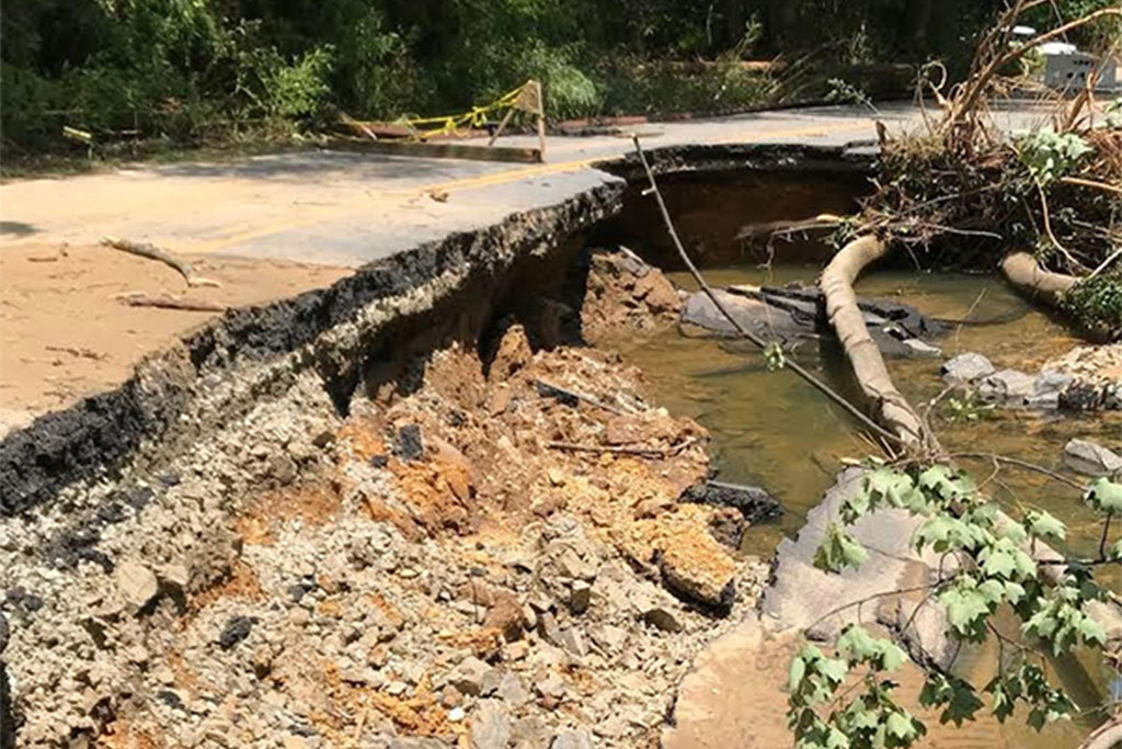
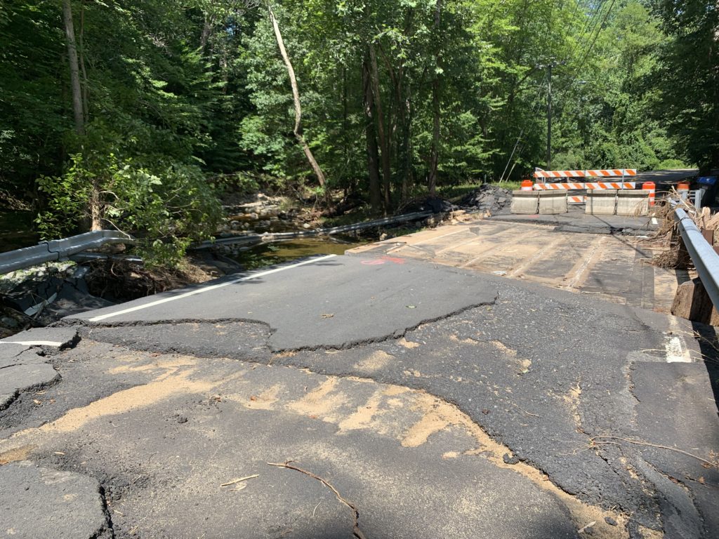
Kirby Road and Swinks Mill Road at the eastern and western edges of McLean respectively are both blocked off at roughly the halfway point where the roads were severely damaged by floodwaters.
Replacing the damaged bridges will take several months, according to Virginia Department of Transportation (VDOT) spokesperson Ellen Kamilakis.
A part of Kirby Road has been broken off with much of the supporting infrastructure underneath completely swept away. According to a press release from VDOT:
-
A segment of road just south of Claiborne Drive was washed away. The remaining asphalt in that location has been undermined.
-
Asphalt on the approaches to the deck of the VDOT bridge over Pimmit Run was damaged, but temporarily repaired the same day. The bridge also has damage to the guardrails and abutments (the “legs” that support the bridge deck) and retaining wall.
-
Pimmit Run will need to be realigned to its original location.
-
The sanitary sewer line and underground utilities were affected.
-
Damage to VDOT infrastructure is not preventing access to any homes.
-
Note: A privately owned and maintained bridge across from Claiborne Drive was severely damaged and homeowners are evaluating repair options.
Meanwhile, at Swinks Mill Road the asphalt on the bridge was completely destroyed, with the guard rail and large chunks of the road visible warped and scattered down the creek bed. According to the VDOT press release:
-
Several hundred feet of asphalt approaching the bridge on both sides was damaged.
-
Asphalt on the bridge deck was destroyed. Also, the bridge has sustained damage to the guardrails, abutments, and retaining wall.
-
Bridge scour (removal of sand and gravel from around the abutments) was observed.
-
Debris was observed in Scotts Run.
-
Damage to VDOT infrastructure is not preventing access to any homes.
Currently, VDOT said surveys are underway for the planned realignment of both streets. Preliminary design work has started for both bridges and road repairs, according to the press release.
Removal of debris is expected to continue alongside more extensive survey work at both locations. Once bridge designs are finalized, VDOT said the bridge and road repair plans will be put out for construction bids.

Update at 2:50 p.m. — The National Weather Service has issued a Severe Thunderstorm Warning for portions of McLean, Vienna and Tysons.
More from NWS:
THE NATIONAL WEATHER SERVICE IN STERLING VIRGINIA HAS ISSUED A
* SEVERE THUNDERSTORM WARNING FOR… THE NORTHWESTERN DISTRICT OF COLUMBIA… SOUTHEASTERN MONTGOMERY COUNTY IN CENTRAL MARYLAND… NORTHWESTERN PRINCE GEORGES COUNTY IN CENTRAL MARYLAND… EAST CENTRAL LOUDOUN COUNTY IN NORTHERN VIRGINIA… NORTHEASTERN FAIRFAX COUNTY IN NORTHERN VIRGINIA…
* UNTIL 330 PM EDT.
* AT 244 PM EDT, A SEVERE THUNDERSTORM WAS LOCATED OVER RESTON, MOVING EAST AT 25 MPH.
HAZARD…60 MPH WIND GUSTS.
SOURCE…RADAR INDICATED.
IMPACT…DAMAGING WINDS WILL CAUSE SOME TREES AND LARGE BRANCHES TO FALL. THIS COULD INJURE THOSE OUTDOORS, AS WELL AS DAMAGE HOMES AND VEHICLES. ROADWAYS MAY BECOME BLOCKED BY DOWNED TREES. LOCALIZED POWER OUTAGES ARE POSSIBLE. UNSECURED LIGHT OBJECTS MAY BECOME PROJECTILES.
* LOCATIONS IMPACTED INCLUDE… ROCKVILLE, BETHESDA, GAITHERSBURG, RESTON, OLNEY, HERNDON, LANGLEY PARK, VIENNA, LOWES ISLAND, MCLEAN, AMERICAN LEGION BRIDGE, ASPEN HILL, POTOMAC, NORTH BETHESDA, OAKTON, STERLING, NORTH POTOMAC, TYSONS CORNER, HYATTSVILLE AND WHITE OAK.
PRECAUTIONARY/PREPAREDNESS ACTIONS…
FOR YOUR PROTECTION MOVE TO AN INTERIOR ROOM ON THE LOWEST FLOOR OF A BUILDING.
Severe Thunderstorm Warning including Silver Spring MD, Rockville MD, Bethesda MD until 3:30 PM EDT pic.twitter.com/ijRuDDuZlF
— NWS Baltimore-Washington (@NWS_BaltWash) July 22, 2019
Earlier: Fairfax County and surrounding areas could see some thunderstorms, flash flooding, rain and strong wind today (Monday).
The National Weather Service recently issued a Severe Thunderstorm Watch that will go into effect at 10 p.m. — possibly overlapping with the Flash Flood Watch, which begins at 3 p.m. and lasts until “late tonight.”
The county can expect heavy rain around 1-2 inches that could cause flash flooding later this afternoon and tonight. Strong thunderstorms may hit northwestern Fairfax County, with gusts up to 50 miles per hour.
The National Weather Service also issued a Special Weather Statement:
…SEVERE THUNDERSTORMS POSSIBLE THIS AFTERNOON AND EVENING…
A cold front approaching the region will interact with an unstable airmass to result in showers and thunderstorms. Some of these thunderstorms may become severe, especially between 2 PM this afternoon and 9 PM this evening.
The main threats with these storms will be:
* Damaging wind gusts
* Heavy rainfall and flash flooding
* Frequent lightningTake time today to review your severe weather action plan. Have a way to receive alerts from the National Weather Service, and be ready to seek safe shelter should storms approach your neighborhood or a warning is issued.
⛈ A cold front is bringing the heat wave to an end, but not without the threat of severe thunderstorms. A Severe Thunderstorm Watch has been issued until 10 pm. Stay weather aware and be ready to move inside if a warning is issued. #VaWx pic.twitter.com/bLN448GToT
— Ready Fairfax (@ReadyFairfax) July 22, 2019
A Flash Flood Watch is in effect for most areas this afternoon through late tonight. Severe thunderstorms are possible this afternoon and evening. See map for more details. pic.twitter.com/Na8nVWgm7u
— NWS Baltimore-Washington (@NWS_BaltWash) July 22, 2019
")
A little more than a week ago, severe flash flooding swept the Tysons area causing widespread damage.
Tysons Reporter reported on a variety of the storm’s impacts from multiple road closures to swift water rescues, from to flooded yards, basements and fields to missing chickens in McLean.
While the recent hot weather dried out the Tysons area, we want to know how much the flooding impacted you.
Let us know in the poll and comment below to tell Tysons Reporter more about your experience.
First photo via @SteveML9022/Twitter
Runoff from construction sites reportedly caused a number of drainage issues around McLean following major flooding last Monday (July 8).
Fairfax County received several complaints last week about construction sites mentioning stormwater runoff and water and mud flooding, according to the Sites Construction Complaints Report, which shows complaints submitted in the last 30 days to Land Development Services.
“Most of the complainants who called this week seemed to think the issues were definitely caused by the heavy rains,” Hanna Kras, a Land Development Services staffer, wrote in an email obtained by Tysons Reporter.
Kras noted that inspectors’ resolutions to complaints will “give a better picture about whether or not these issues were driven by the flooding.”
“After a rain event like this, our inspectors respond to emails and phone calls about run-off and debris from construction sites that are impacting neighboring properties,” Anne Cissel, the spokeswoman for Land Development Services, told Tysons Reporter.
Cissel added that inspectors are “still catching up on filing their reports into the system.”
In a complaint last Wednesday (July 10), a woman reported that new construction in the 6500 block of Smoot Drive switched the grade from facing toward the street to facing toward her mom’s house, resulting in runoff.
Inspectors told the builder to fix a silt fence that “was breached due to Monday’s flood flush.” The inspectors were scheduled to meet with the complainant this morning.
Last Thursday (July 11), someone also complained about trash and portable toilet spill at 7006 Elizabeth Drive: “Due to recent flooding, a drainage problem has been noted. Portable toilet spill. Construction debris spill.”
In another complaint on Friday, July 12, someone reported worsening gravel and debris issues at 6500 Tucker Avenue, adding that “with the recent rain downpours, it has gotten even worse, spreading all over the roads making them hazardous in our area.”
These three complaints are still marked as “open” or “in progress” as of this afternoon.
One complaint the county closed was from last Wednesday (July 10) about a blocked drain that flooded a street and nearby yard. The inspectors found that the contractor at 1629 Wrightson Drive “had inlet protection at the storm structure… [The contractor] will remove inlet protection when expecting heavy rain.”
When asked if crews had trouble getting to the sites because of the storm damage, Cissel responded, “Kirby Road is closed and Benjamin [Street] was also impacted.”
Photo via @SteveML9022/Twitter

One day after a GoFundMe campaign launched to help the McLean Little League repair damage to its complex from Monday’s flash flooding has already raised more than $18,000.
Started yesterday (Wednesday), the fundraiser has raised about a quarter of its $75,000 goal.
“We have set up this fund to help cover the cost of repairs (given our location, we do not have flood insurance),” according to the GoFundMe.
Currently, the McLean Little League complex is closed.
Work to repair the damage will include rebuilding two dugouts, repairing fencing on three of the four fields and cleaning up the fields at the complex (1836 Westmoreland Street), Jen Nance, the president of the McLean Little League, previously told Tysons Reporter.
The aim is to get the work done before the fall season starts.
")
After major flash flooding caused widespread damage on Monday (July 8), Dranesville District Supervisor John Foust shared how the county can better prepare for future storms and what steps are currently underway.
“It was horrific in certain areas,” Foust said. “It came by and went so fast.”
Foust said that while he wasn’t surprised by the damage from the flash flooding on Monday, it was the worst he has ever seen in Fairfax County.
Tysons Reporter talked to Foust about how work after the storm has been going around the Tysons area and what infrastructure improvements are needed to help the county weather the next big storm.
When the flooding started, Foust said he was inside his home during the brunt of the storm, waiting to get to his car parked outside. Eventually, Foust said he was able to get outside and drive to his office, which is nearby — “Pretty easy compared to what many had to go through,” he said.
Assessing the Damage
From a multitude of road closures to flooded backyards, from more than 55 water rescues to three missing chickens swept away, clean-up and assessment are still underway across the county.
In an email to residents last night (Wednesday), Foust urged people affected by the storm to submit information online to a disaster damage database to help the county with its damage assessment. People can submit reports until Wednesday, July 24.
“While owners are responsible for repairs on their property, the county could use this data to pursue disaster aid through the federal government to the extent such aid is available,” Foust wrote.
The Town of Vienna also tweeted about the database, writing, “Damage reports may impact what — if any– federal disaster assistance may be made available.”
As for the cleanup efforts this week, Foust said, “The county staff performed extremely well.”
Foust also praised the county’s work on stream restoration, which recently included Bull Neck Run and Dead Run Stream.
Road Work Underway
Foust said that several improvement projects are slated to help roads weather serious flooding in the future, including Tucker Avenue and Chesterbrook Road in McLean.
The Tucker Avenue project will address flooding along the avenue from Birch Street to where it deadends at the Pimmit Run stream. Project design is set to start this summer, he said.
“It’s almost scary what happens on that road when it rains hard,” he said because of the road’s incline may make it the worst road for flooding in the McLean District. “Not a meandering stream but a roaring river.”
The Chesterbrook project at the intersection of Chesterbrook Road and N. Albemarle Street is set to add a larger pipe for more water. While the Virginia Department of Transportation had said that the project may start in the fall, plans have not been finalized, he said.
In addition to the work on those local roads, Fouse said that the Route 7 widening project includes elevating the road where Dead Run Stream regularly floods Route 7.
Preparing for the Next Big Flood
Going forward, “a lot of things need to be done,” Foust said to minimize damage from another major storm.
McLean and the general area around Tysons were built before stormwater management requirements, which the county is now trying to superimpose with a new system, he said.
Foust said that as changing weather patterns could see severity increase for future storms, he wants the county to prioritize funding stormwater management projects and work with developers of infill projects, which develops vacant or under-used areas within existing urban areas, to better manage stormwater sites.
“The funding is never adequate,” Foust said Capital Improvement Program funding for stormwater management projects. “You do the best you can with the resources you have. For available resources, we need to prioritize stormwater management projects more than in the past.”
Whenever the next big flash flooding hits, Foust said that he hopes for more notice from forecasters.
“It’s one thing when you see it coming,” he said.
")
The National Weather Service issued Flash Flood Watch for Fairfax County and surrounding areas just days after major flooding hit.
The watch is in effect from 2 p.m. through late tonight (July 11).
More from NWS:
* Showers and thunderstorms are expected this afternoon and evening. Torrential rainfall may lead to totals exceeding 2 inches in a short period of time. This may cause flash flooding of small streams and other poor drainage urban areas.
PRECAUTIONARY/PREPAREDNESS ACTIONS…
A Flash Flood Watch means that conditions may develop that lead to flash flooding. Flash flooding is a very dangerous situation.
You should monitor later forecasts and be prepared to take action should Flash Flood Warnings be issued.
After more than 55 water rescues on Monday, forecasters are also reminding people to “turn around, don’t drown” when encountering water of unknown depth on the roads.
A Flash Flood Watch has been issued for areas in green from 2pm through tonight. 2+ inches of rainfall in a short period of time is possible. This could cause flash flooding of streams and other poor drainage urban areas. Remember, turn around, don't drown! pic.twitter.com/UqGQa0Hhla
— NWS Baltimore-Washington (@NWS_BaltWash) July 11, 2019
")
If you spot chickens in McLean, they may be the three ones reported missing from a backyard coop that was washed away in flash floods on Monday.
Cat McGill told Tysons Reporter that her family and a neighboring family on Great Falls Street by Pimmit Run Stream started a joint venture to keep chickens on their combined 3.5 acres of land.
“We got them because the kids didn’t have any pets,” McGill said, adding that her 1.5-year-old son and the neighbors’ kids, ages 13 and 7, shared them. “My son literally has to see — he calls them cluck clucks — the cluck clucks every single day.”
The kids named the Buff Orpington chickens, which they had for about two years, Peridot, Peril and Gerboa, she said. (Previous chickens they had were named Beyonce and Katy Perry.)
The kids don’t know yet that their pet chickens are missing — McGill is with her son in Ohio at the moment and the neighbors’ kids are on vacation. “They are just going to be heartbroken,” she said.
When the flooding happened, the chickens were in a large coop outside that doesn’t have a bottom. She said a neighbor found a part of the structure by the McLean Little League fields.
At first, McGill thought that the chickens were washed away, but then someone posted a photo on Nextdoor of chicken “paw prints” by where the coop crashed, giving her renewed hope that they might still be alive.
McGill said it’s been heartening to see so many people searching for the chickens — “There are some very sweet neighbors.”
In addition to the missing chickens, McGill said that about 4 feet of water flooded the 3.5 acres destroying their bridge and a shed and floated the kids’ playset away.
“The chickens are the only thing we’re upset about,” she said about the damage.
If you see any chickens, email [email protected] and we’ll make sure McGill gets the information.
Photo courtesy Cat McGill