
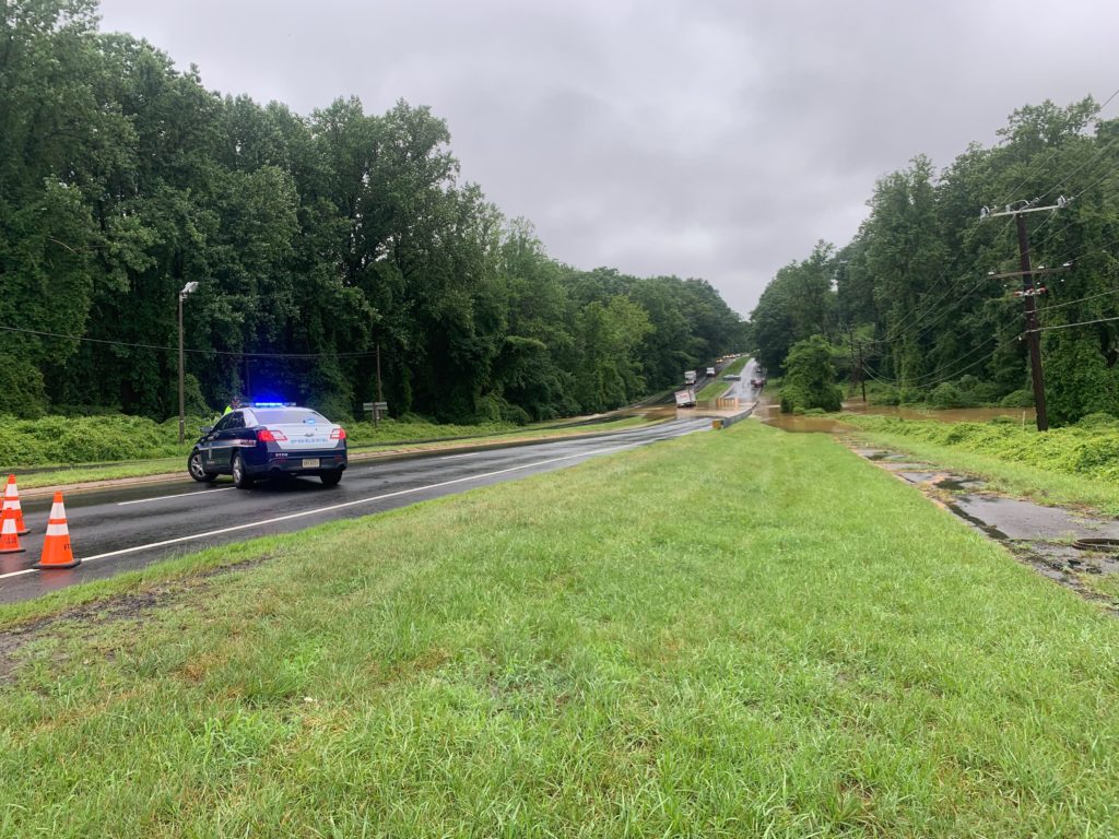
Updated at 9 a.m. — The Fairfax County Park Authority said this morning (July 10) that the west parking lot at Scott’s Run and bridge at Lewinsville Park are still closed.
Around the Tysons area, work is underway to clean up and repair roads, parks and even a high school after severe flash flooding yesterday.
“Nearly 5 inches of rain fell on Fairfax County Monday morning — nearly a month’s worth of rain in just a few hours, overwhelming numerous parts of our public infrastructure,” according to Fairfax County.
McLean High School had two hallways flooded along with the athletic locker rooms and coaches’ offices, Ellen Reilly, the principal of the high school, told Tysons Reporter, adding that Fairfax County Public Schools assessed the school today (July 9) to make sure that all of the areas were safe.
“Custodial staff worked throughout the day pumping out the water from the locker rooms and the carpets will be shampooed once everything dries out,” Reilly said.
The staff received a shout out on the high school’s Twitter:
Thanks to our custodial staff for cleaning up after the flooding that occurred throughout our school yesterday. They are amazing! pic.twitter.com/CAQ4BwDPdy
— McLean Highlanders (@mcleanhigh) July 9, 2019
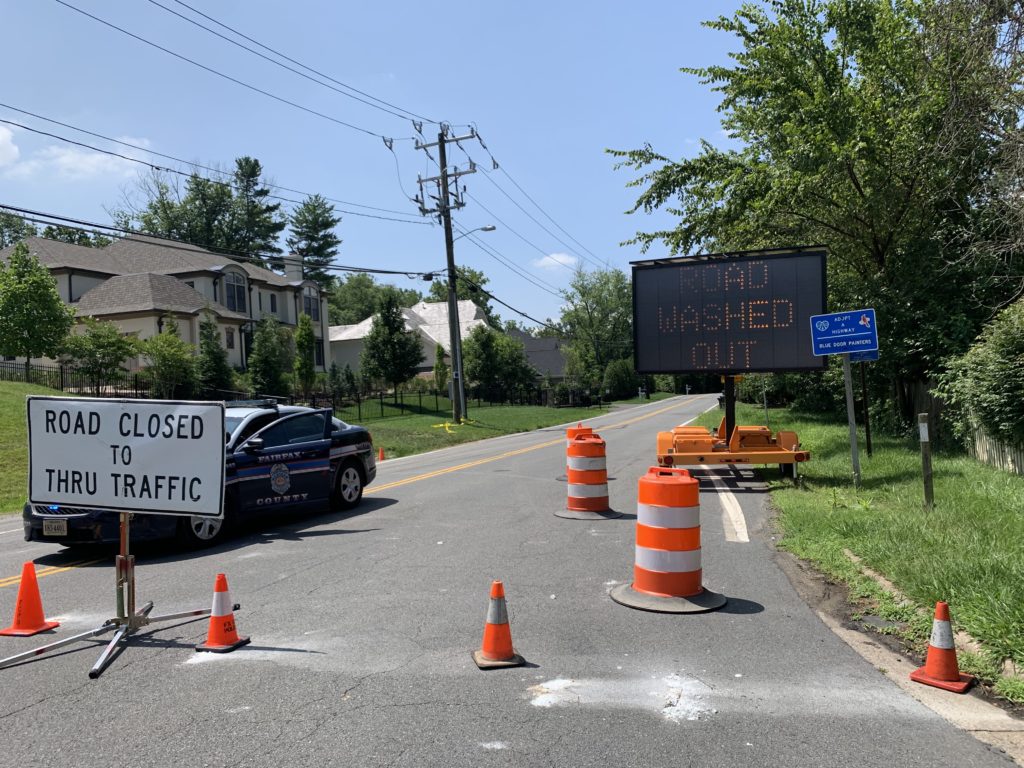
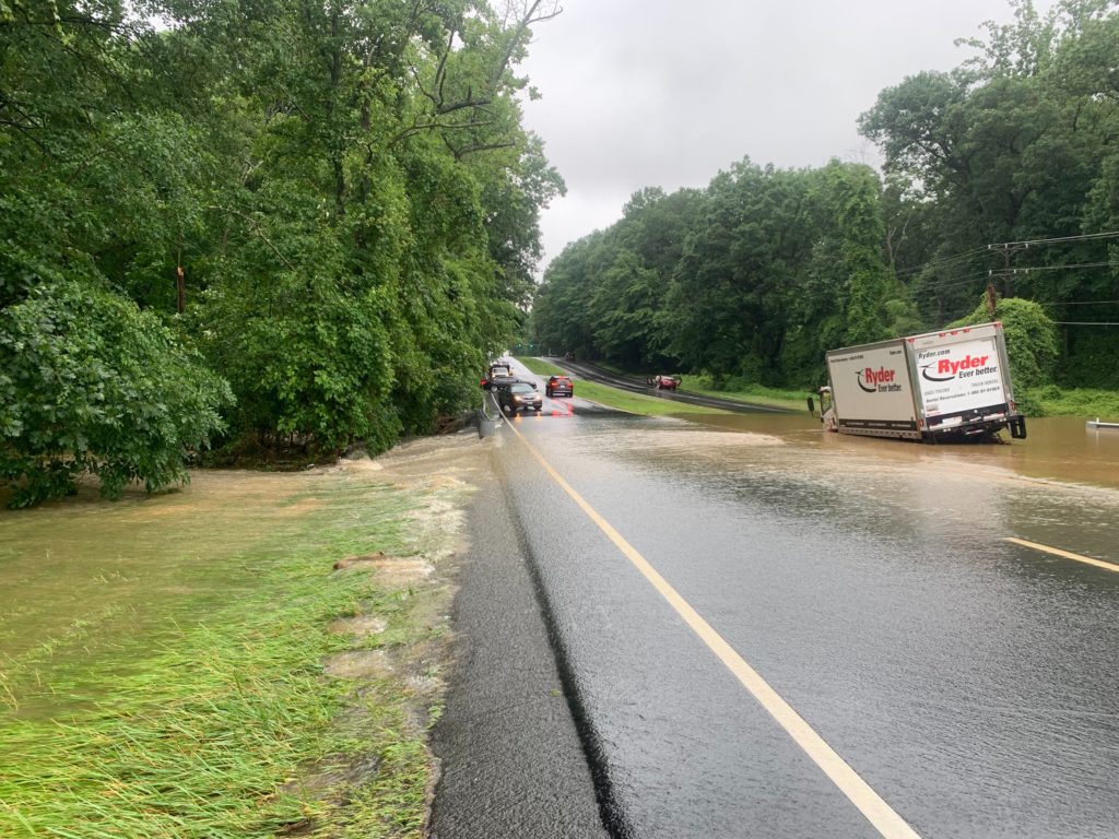
Kirby Road will continue to be closed in McLean for several weeks as crews work to repair extensive damage.
The Fairfax County Park Authority said this morning that several parks in the Tysons area are closed as park teams assess the damage, including the west parking lot at Scott’s Run and bridge at Lewinsville Park.
Scotts Run Nature Preserve receives much of the runoff from Tysons rains. Even the slightest bit of rain can turn the serene stream into a raging river. Always use caution. @FairfaxCountyPD @fairfaxcounty @ffxfirerescue https://t.co/m9O7cBWf5Q
— Fairfax County Parks (@fairfaxparks) July 8, 2019
Update on 7/10/19 — Both lanes of Kirby Road from Dolley Madison Blvd. to Claiborne Drive are open, but traffic barriers have been set up past that, according to information from the Fairfax County Office of Emergency Management and forwarded by Dranesville District Supervisor John Foust.
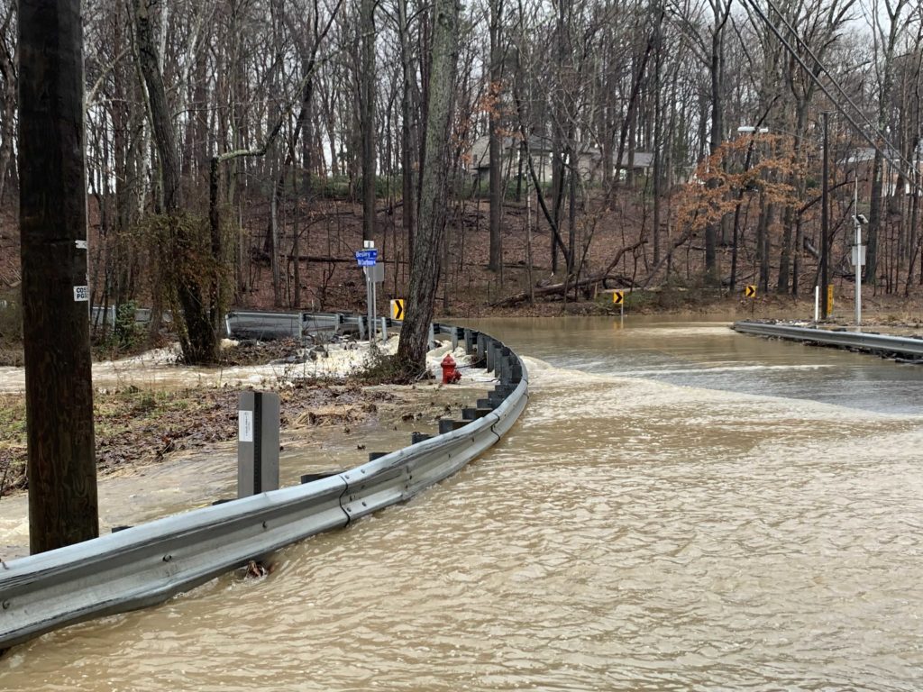
Earlier: Severe weather damage will keep Kirby Road closed in McLean to through-traffic for the foreseeable future.
The road runs from Dolley Madison Blvd near the George Washington Memorial Parkway down to Great Falls Street. But flooding at Pimmit Run from storms yesterday means that while residents in the area are able to access their homes, the route no longer connects Dolley Madison Blvd to Old Dominion Drive.
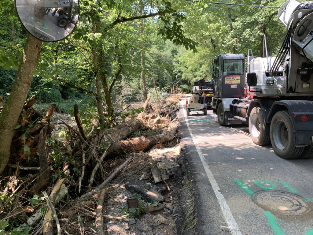
Kirby Update: Crews cleared more debris for access. But as you can see, the road will be closed for some time. We added more layers of barricades 🚧 to keep people from going around the barriers to walk/bike on the damaged road. Huge thanks to @FairfaxCountyPD for their support! pic.twitter.com/xdHFY8KZuL
— VDOT Northern VA (@VaDOTNOVA) July 9, 2019
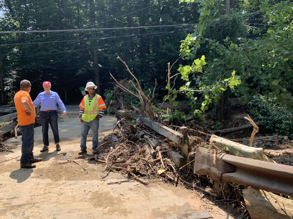
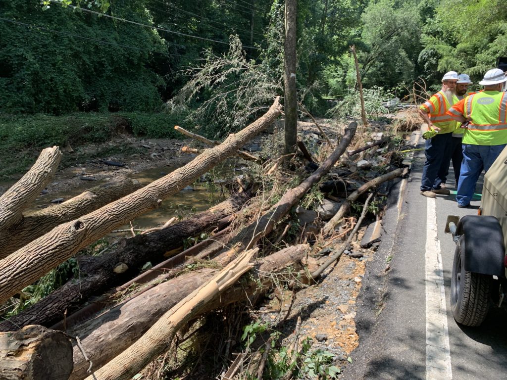
“We have no specific timeline, but it will be weeks,” Ellen Kamilakis, a spokesperson for the Virginia Department of Transportation, told Tysons Reporter. “The water tore right through the road [and] exposed the area underneath all the way.”
RT @FairfaxCountyPD: The 1300 block of Kirby Road in McLean suffered extensive damage due to today’s storm. It will be closed for significant time until the damage can be assessed and repaired. #FCPD #FairfaxCounty #TurnAroundDontDrown pic.twitter.com/VeV7ILqmDZ
— Fairfax County Fire/Rescue (@ffxfirerescue) July 8, 2019
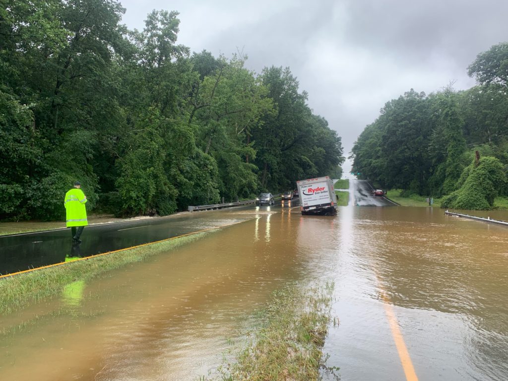
Part of the upper asphalt is visible carved away by the storm, but Kamilakis said the damage underneath is so extensive that the road would not be able to support the weight of a car. Kamilakis said the road will require complete reconstruction — and a review of whether the road needs stormwater upgrades.
Earlier today (Tuesday) traffic on the road was stopped near Dolley Madison Blvd as the crew worked to finish clearing a debris-cluttered bridge, but Kamilakis said the closure will be tightened up to just the area immediately surrounding the broken section of the road.
Kamilakis said the cleaning crews had been working overnight to clear away the debris, and the VDOT Twitter noted that the efforts were rewarded by one local man who brought water to the workers.
KINDNESS MATTERS: Crews have been working on Kirby since last PM. This nice resident brought our crews water. This def makes up for a couple residents who were (unfortunately) not so kind about us not letting them walk across a washed out road. PLEASE don’t cross our barriers! pic.twitter.com/Q1iTPDqoIQ
— VDOT Northern VA (@VaDOTNOVA) July 9, 2019
Those trying to get from northern McLean to areas near Arlington will either have to go thrown “downtown” McLean or go further east to Glebe Road.
A significant section of Kirby Road between Chesterbrook Road and 123 is closed. Drivers should avoid Kirby in this area if possible.
VDOT crews will be working to make repairs to the road overnight and emergency personnel are on-site to escort residents to their homes. #McLean
— John Foust (@johnfoustva) July 8, 2019
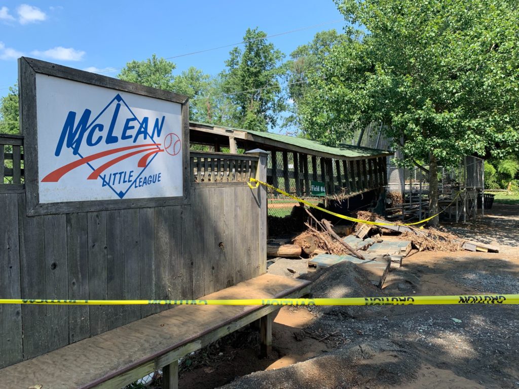
Following extensive damage from flash flooding yesterday (Monday), the McLean Little League is looking to repair its complex during the off-season.
Jen Nance, the president of the McLean Little League, told Tysons Reporter that the “serious damage” is still being assessed after the creek behind the facility flooded the fields at 1836 Westmoreland Street.
“It was definitely the most floodwaters we have seen in any recent history,” Nance said, adding that the flashing flooding “wreaked havoc.”
Before the flooding started, the facility managed opened up the fields for a local baseball group to use them for a camp this week. Seven cars belonging to the group’s coaches ended up floating around in the flooded parking lot during the brunt of the storm, Nance said. Luckily, no one was hurt.
By 12:30 p.m. yesterday, most of the water had receded from the fields, making the damage clearly visible. “[You] can tell where the debris from the creek got stuck in the fencing,” Nance said. “Debris is at least 6 feet up on the fence.”
Nance said that work will include rebuilding two dugouts, repairing fencing on three of the four fields and cleaning up the fields, adding that the tee-ball field has the worst amount of damage, while the front field suffered the least.
Currently, the McLean Little League complex is closed — “it’s not a secure, safe situation right now,” she said — and the nonprofit is working with vendors to determine the cost and timeframe for repairs.
“We’re thinking we can get it all repaired by the fall season,” Nance said, adding that “it’s too soon to know” when the repairs will be finished.
Tysons Reporter spoke to contractors inspecting the site today (July 9), who said that the goal is to reopen the complex by Labor Day.
While the McLean Little League hasn’t started a GoFundMe yet, Nance said that community fundraising is one option to pay for the repairs.
“We are a nonprofit, so we rely heavily on our community and donors,” she said. “This is a once in many year occurrence.”
Because of the timing of the flooding, Nance said that she expects the damage to have little impact on the team or the local community, which often will use the field.
“We don’t have games. The seasons are wrapping up,” she said. “I think it will be hopefully minimal. If we get rolling soon, there will be no impact on the fall season.”
For people who want to stay updated on the repair status, Nance recommends checking the McLean Little League’s Twitter and Facebook. Nance also suggests keeping an eye out for registration for the fall season, which is set to open in the next couple of weeks.
“We will likely continue to update via Twitter. Our population looks to that Twitter feed,” she said.
McLean Little League looks like a war zone. Cars being towed away now. Baseball camp coaches watched as the flood water piled their vehicles on top of one another this morning @fox5dc pic.twitter.com/UmwR65Mons
— Lauren DeMarco (@Ldemarconews) July 8, 2019
Vernon Miles contributed to this story
")
Updated at 9 a.m. on 7/9/19 — Updates FCPD list of road closures below. Only Kirby Road is still closed.
Updated at 5:45 p.m. — Fairfax County police said that the 1300 block of Kirby Road will be closed “for significant time” while the damage is assessed.
The 1300 block of Kirby Road in McLean suffered extensive damage due to today's storm. It will be closed for significant time until the damage can be assessed and repaired. #FCPD #FairfaxCounty #TurnAroundDontDrown pic.twitter.com/ZwzLIY0A9E
— Fairfax County Police (@FairfaxCountyPD) July 8, 2019
Updated at 5:35 p.m. — In Falls Church, S. Oak Street remains closed because the bridge’s surface was damaged by the rain and Hillwood Avenue did not have a sinkhole, but the road buckled from the rain. A temporary fix is in place for the avenue, and a permanent fix will be made this week.
Flooding has apparently closed Westmoreland Street (exit 68) by I-66 in Falls Church.
https://twitter.com/bellwetherevent/status/1148294098488573952
Updated at 4:50 p.m. — Updated FCPD list of road closures below.
Updated at 2:40 p.m. — Dranesville District Supervisor John Foust tweeted at 2:30 p.m. that a part of 1300 block of Kirby Road has been washed out and that “several agencies are on scene to find a solution to make sure residents can get to their homes.”
Updated at 2:15 p.m. — Updates FCPD list of road closures below.
Updated at 1 p.m. — The Fairfax County Police Department tweeted that Prosperity Avenue between Arlington Blvd (Route 50) and Little River Turnpike (Route 236) is buckled and could take up to seven hours for the water to recede. “Due to there being a lot of serious damage to the pavement, the road will not reopen this quickly,” FCPD tweeted.
Updated at 12:40 p.m. — A multi-vehicle accident on I-66 by N. West Street in Falls Church has closed the left shoulder and left lane heading eastbound, according to the Virginia Department of Transporation.
Updated at 11:50 a.m. — Kirby Road is reportedly closed near Route 123 as Pimmit Run swells.
https://twitter.com/ABC7TimBarber/status/1148255842367619079
https://twitter.com/danesh68/status/1148257403579904002
Flooding in McLean @ Kirby Road as Pimmit Run pours over its banks pic.twitter.com/Ta4GFHIoMp
— Peggy Fox (@PeggyTV) July 8, 2019
Updated at 11:25 a.m. — Maple Avenue is now open again, the Town of Vienna tweeted.
Earlier: Parts of Maple Avenue in the Town of Vienna and several roads around the Tysons area are closed this morning as flooding continues around Fairfax County.
The Town of Vienna tweeted shortly after 10 a.m. that Maple Avenue is closed between East Street and Beulah Road due to flooding.
Westbound Arlington Blvd (Route 50) just past Prosperity Avenue is closed due to flooding. Police told Tysons Reporter that they don’t have enough police to block the other side of the street, which also appears flooded.
Around 10:35 p.m., police said that all of the units in the county were currently deployed.
Fairfax County Police Department released a list of road closures. The ones closed due to flooding in the McLean Police District are:
1300 block of Kirby Road — damaged from flooding and will have a long-term closure
Shreve Road between Wieland Place and Buckelew Drive
Hilltop Road between Willomere and Old Lee Hwy
Meadowlark Road/Brookside Lane
Demsey Street/Old Chesterbrook Road
Old Courthouse and Besley roads
Georgetown Pike and Potomac River Road — one lane closed
6500 block of Old Dominion Drive
North Albemarle Street/Chesterbrook Road — flooding and debris
Westbound Arlington Blvd/Prosperity Avenue — one lane open
Jones Branch Road/Park Run Drive
Lewinsville Road/Lewinsville Mews Court
Beulah and Browns Mill roads
Oberon Way/Capulet Court
A fallen tree closed the 1400 block of Waggaman Circle, according to FCPD, but the road has since reopened.
People tweeted videos and photos of severe flooding along Georgetown Pike.
https://twitter.com/JaeReaves/status/1148244995595493376
@dougkammerer Georgetown Pike in Great Falls VA this morning. Water really pooling up pic.twitter.com/wpk1y3OZJo
— WFO (@WFOcom) July 8, 2019
One car is already stuck on the flooded roads on Georgetown pike. @WTOP @WTOPtraffic @nbcwashington don’t try it people. #notsmart pic.twitter.com/WiQrmQjbXj
— Tony mace (@E4Mace) July 8, 2019
The City of Falls Church tweeted about several road closures and sinkholes in the city this morning.
Catherine Moran and Vernon Miles worked on this story.
Updated at 1:35 p.m. — Fairfax County Fire and Rescue tweeted that firefighters rescued the driver of a box truck on Arlington Blvd near Prosperity Avenue around 9:45 a.m.
Around 9:43 this morning. #FCFRD rescued the driver of this box truck on Arlington Boulevard near Prosperity Avenue in the Merrifield area. Note that the water was strong enough to move truck off roadway and almost tipped it over. No injuries. #FCFRD #FairfaxCounty pic.twitter.com/sgSKYNuHO0
— Fairfax County Fire/Rescue (@ffxfirerescue) July 8, 2019
Updated at 12:25 p.m. — Fairfax County Fire and Rescue tweeted that it has responded to 55 swift water rescue calls.
Tripps Run has reportedly flooded into backyards and basements in the City of Falls Church.
https://twitter.com/jwhopewell/status/1148231426963210241
Updated at 12:05 p.m. — A spokesperson for the Arlington County Fire Department said that AFCD responded to a hazmat call for a flooded building with a fuel leak in the basement at Coleman PowerSports at 435 S. Washington Street in Falls Church.
Updated at 11:20 a.m. — First responders continue responding to numerous reports of flooded roads and swift water rescues.
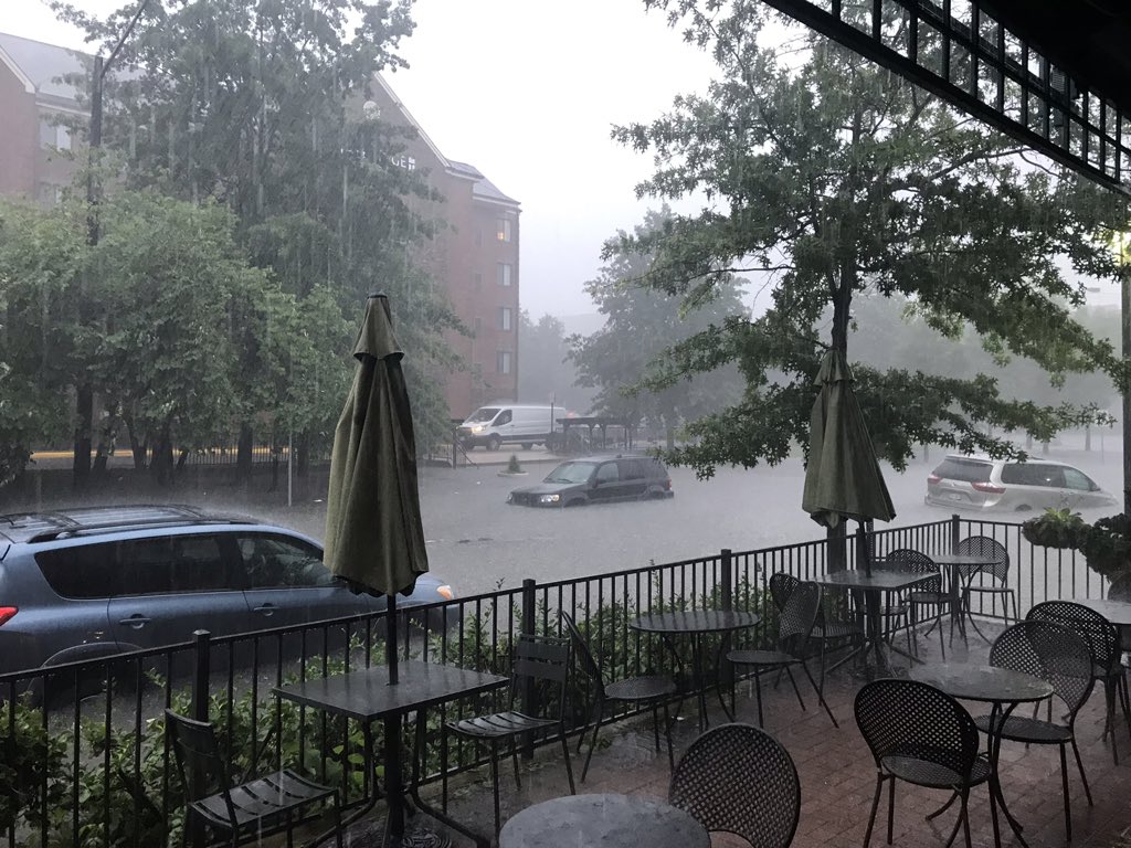
Earlier: As flash flooding hits Fairfax County, several drivers are stranded in flooded roadways in McLean, Vienna and Merrifield.
Fairfax County Fire and Rescue tweeted at 9:46 a.m. today (July 8) that units are responding to about 30 calls for swift water rescues. The fire department tweeted earlier this morning that a majority of its roughly 11 calls were in the McLean and Vienna areas.
“If you do not have to be on the roads right now – stay off,” the fire department tweeted.
Tysons Reporter spotted several cars backed up and in water along Arlington Blvd (Route 50), which was flooded by Prosperity Avenue.
Earlier today, Fairfax County Fire and Rescue got three occupants out of a car stuck in the flooded roadway at Meadowlark Road and Brookside Lane in the Wolf Trap area.
Fairfax County Fire and Rescue also responded to a swift water rescue in the 6500 block of Old Dominion Drive in the McLean area and worked to rescue two occupants from the car.
Major flooding! Cars trying to navigate Dolley Madison Blvd in McLean, VA @nbcwashington pic.twitter.com/wb3ZD5nwGk
— Susan Hogan (@susanhogantv) July 8, 2019
https://twitter.com/JaeReaves/status/1148244995595493376
Units are responding to over ELEVEN (11) calls for help from motorists stranded in flooded roadways. PLEASE TURN AROUND and DON'T DROWN. Majority of calls are in McLean/Vienna area. If you do not have to be on the roads right now – stay off! #FCFRD #FairfaxCounty pic.twitter.com/PXWCaCTzDh
— Fairfax County Fire/Rescue (@ffxfirerescue) July 8, 2019
MT @ffxfirerescue: Currently working/responding to over 30 calls for swift water rescues. If you encounter a flooded roadway, please TURN AROUND DON’T DROWN! Please stay where you are and delay any travel until rain stops. pic.twitter.com/ll2eGiqW7Z
— Fairfax County Government 🇺🇸 (@fairfaxcounty) July 8, 2019
Catherine Moran and Vernon Miles worked on this story.
First photo via @SteveML9022/Twitter
")
Updated at 2:10 p.m. — NWS extended the Flood Warning for parts of Fairfax County to 6 p.m.
At 1252 PM EDT, reporting gauges indicate larger streams are still rising from the earlier torrential rain, and many road closures are still being reported. Although the threat of rapid rise life threatening flooding is diminishing, some flooding is likely to continue for the rest of the afternoon. Therefore, this Flood Warning replaces the Flash Flood Warning.
Updated at 10:25 a.m. — NWS extended the Flash Flood Warning for parts of Fairfax County to 1:45 p.m.
Earlier: A Flash Flood Warning is in effect for Fairfax County, the City of Falls Church and surrounding areas this morning.
The National Weather Service issued the warning right after 8:30 a.m. today (July 8). The warning will be in effect until 10:45 a.m.
More from NWS:
At 829 AM EDT, Doppler radar and automated rain gauges indicated that heavy rain was falling over the area. Up to two inches of rain have already fallen, and another one to two inches of rain are likely. Flash flooding is already occurring. Rock Creek is extremely likely to flood in the next hour or two, potentially significantly. This will force additional road closures beyond what are already ongoing. DO NOT DRIVE into areas where water covers roadways and especially not where water is flowing on or across them!!!
Some locations that will experience flooding include… Arlington, Alexandria, Bethesda, Reston, Olney, Herndon, Langley Park, Vienna, Falls Church, Lowes Island, Pimmit Hills, Poolesville, Mclean, American Legion Bridge, Fort Totten, Rosslyn, Aspen Hill, Potomac, North Bethesda and Ashburn.
Flash Flood Warning area in county has expanded. Be aware and be prepared! If you encounter a flooded roadway, please TURN AROUND DON’T DROWN! Do not put you or our firefighters/paramedics in harm’s way unnecessarily! https://t.co/sA2TS4UyUb #FCFRD #FairfaxCounty #SafeFairfax
— Fairfax County Fire/Rescue (@ffxfirerescue) July 8, 2019
MT @NWS_BaltWash: Torrential rainfall crossing DC metro area during the AM commute. Numerous FLASH FLOOD WARNINGS are in effect. Flooding will likely impact normal commuting patterns. If water covers a roadway, FIND ANOTHER ROUTE!
— Fairfax County Government 🇺🇸 (@fairfaxcounty) July 8, 2019
Flash Flood Warning including Arlington VA, Silver Spring MD, Bethesda MD until 10:45 AM EDT pic.twitter.com/VQdgcD1vmw
— NWS Baltimore-Washington (@NWS_BaltWash) July 8, 2019
")
Updated at 2:45 p.m. — NWS canceled the Flash Flood Watch for Fairfax County.
Earlier: Get ready for heavy rain this afternoon and evening.
Fairfax County and surrounding areas are under a Flash Flood Watch starting at 2 p.m. today (Monday).
More from the National Weather Service:
* From 2 PM EDT this afternoon through this evening
* Numerous to widespread showers and thunderstorms are expected this afternoon and this evening in a very warm and humid environment. There is potential for showers to move repeatedly over the same areas and to produce intense rainfall rates in a short period of time that may lead to flash flooding. The greatest risk of flash flooding is across northern and central Maryland.
NWS wants people to monitor the forecast and stay alert to any possible Flash Flood Warnings that may pop up.
The Flash Flood Watch has been trimmed back and now only includes much of northern/north-central MD. Numerous thunderstorms still expected this afternoon, some of which could produce damaging winds. Most likely time period is between 2-8pm. #DCwx #MDwx #VAwx #WVwx pic.twitter.com/NNcL63kHTK
— NWS Baltimore-Washington (@NWS_BaltWash) June 17, 2019

Update 1 p.m. — The National Weather Service has issued a Tornado Watch for the region until midnight with Flash Flood Watch remaining in effect.
Hope you brought a rain jacket, Tysons, because the region is expected to get soaked this afternoon (Friday) through tomorrow morning.
A Flash Flood Watch has been issued for the region, including Fairfax County, with 1.5-2 inches of rain expected but even more possible. More from the National Weather Service:
…FLASH FLOOD WATCH REMAINS IN EFFECT FROM NOON EDT TODAY THROUGH LATE TONIGHT… SHOWERS AND THUNDERSTORMS WITH HEAVY RAIN ARE EXPECTED TO OVERSPREAD THE REGION BY THIS AFTERNOON AND CONTINUE THROUGH THIS EVENING BEFORE DEPARTING LATE TONIGHT. REPETITIVE STORMS AND MULTIPLE ROUNDS OF HEAVY RAIN MAY RESULT IN RAINFALL AMOUNTS WHICH COULD EXCEED 3 INCHES LOCALLY. FLASH FLOODING IS POSSIBLE, PARTICULARLY IN URBAN AREAS AND IN AREAS OF STEEP TERRAIN. PRECAUTIONARY/PREPAREDNESS ACTIONS… A FLASH FLOOD WATCH MEANS THAT CONDITIONS MAY DEVELOP THAT LEAD TO FLASH FLOODING. FLASH FLOODING IS A VERY DANGEROUS SITUATION. YOU SHOULD MONITOR LATER FORECASTS AND BE PREPARED TO TAKE ACTION SHOULD FLASH FLOOD WARNINGS BE ISSUED. &&
The flooding potential is of particular concern to parts of the Tysons, McLean and Vienna area that are flood prone.
The potential for severe weather has also prompted some airlines to waive change fees for travel Friday. Forecasters say damaging storms are possible later today.
Severe thunderstorms with considerable potential for producing DAMAGING WIND gusts and a few tornadoes are LIKELY across much of the southern through mid Atlantic Coast region, particularly across the Carolinas into southern/central Virginia, THIS AFTERNOON and EVENING. @NWSSPC pic.twitter.com/3GItR4Z0Rg
— National Weather Service (@NWS) April 19, 2019
With storms in the forecast, several airlines, including @united & @Delta, are offering change fee waivers for travel today. Contact the airline directly if travel plans are impacted by weather & be sure to double check the status of your flight before coming to the airport. pic.twitter.com/HaFHwIWP50
— Reagan Airport (@Reagan_Airport) April 19, 2019
If last week’s surprise rainstorm was any indication, the Tysons area is in for a wet spring and some extensive flooding.
Last year was the rainiest on record for the region, which has not only taken a toll on local roads but also hit the area with flooding that has frequently closed streets.
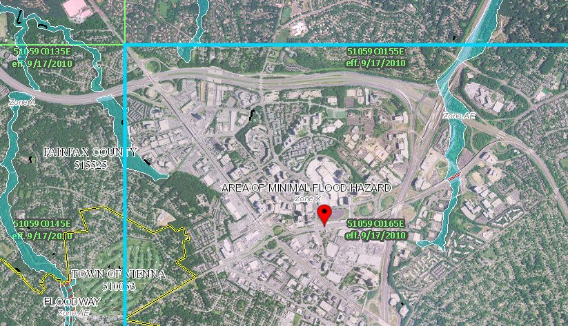
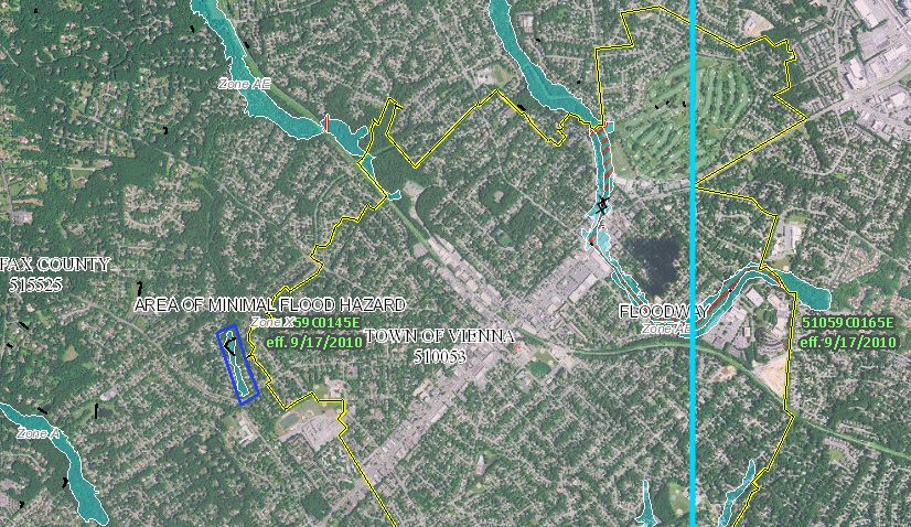
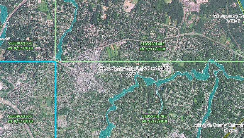
A map put together by the Federal Emergency Management Agency showed the regional flood hazard areas, which unsurprisingly mostly follow local creeks.
Most of the flood hazards around Tysons itself are on the periphery. Old Courthouse Spring Branch just west of the Spring Hill Metro station is vulnerable to flooding, as is Scott’s Run, which runs through Tysons East.
In Vienna, the main flooding hazard is Wolftrap Creek, which runs along the Tysons-Vienna border. There are several low roads through the area, like Old Courthouse Road, which are subject to being washed out during flooding. The area north of Vienna along Piney Branch is also susceptible to flooding.
A 2016 study found that the sewer system along Maple Avenue in Vienna would be unable to handle significant rainfall, but sewer renovations remain unfunded.
In McLean, Dead Run Stream and Pimmit Run are both flood hazard areas, though Dead Run Stream has recently completed a series of revitalization projects whose aim was partially reducing the amount of flooding in the park.

A steady, soaking rain today may lead to flooding around Fairfax County and Northern Virginia.
The National Weather Service says 1-3 inches of rain will fall today, with the heaviest rain between 10 a.m.-6 p.m. The rain may cause creeks and streams to rise and flood low-lying areas, forecasters say.
A soaking rain is expected for most of the area today and a Flood Watch is in effect for portions of the area. For more details on the Flood Watch, click on the image attached. pic.twitter.com/FM05bEkfXs
— NWS Baltimore-Washington (@NWS_BaltWash) March 21, 2019
More from NWS:
…FLOOD WATCH NOW IN EFFECT FROM 10 AM EDT THIS MORNING THROUGH THIS EVENING… THE FLOOD WATCH IS NOW IN EFFECT FOR * PORTIONS OF MARYLAND, THE DISTRICT OF COLUMBIA, AND NORTHERN VIRGINIA, INCLUDING THE FOLLOWING AREAS, IN MARYLAND, ANNE ARUNDEL, CARROLL, CENTRAL AND SOUTHEAST HOWARD, CENTRAL AND SOUTHEAST MONTGOMERY, FREDERICK MD, NORTHERN BALTIMORE, NORTHWEST HARFORD, NORTHWEST HOWARD, NORTHWEST MONTGOMERY, PRINCE GEORGES, SOUTHEAST HARFORD, AND SOUTHERN BALTIMORE. THE DISTRICT OF COLUMBIA. IN NORTHERN VIRGINIA, ARLINGTON/FALLS CHURCH/ALEXANDRIA, EASTERN LOUDOUN, FAIRFAX, PRINCE WILLIAM/MANASSAS/MANASSAS PARK, AND WESTERN LOUDOUN. * FROM 10 AM EDT THIS MORNING THROUGH THIS EVENING * A WIDESPREAD SOAKING RAIN OF 1 TO 2 INCHES IS EXPECTED. ISOLATED AMOUNTS OF AROUND 3 INCHES ARE POSSIBLE. THE STEADIEST RAIN IS EXPECTED BETWEEN 10 AM THIS MORNING AND 6 PM THIS EVENING, WITH RESIDUAL RUNOFF POSSIBLY PERSISTING THROUGH LATE THIS EVENING. * THESE RAINFALL AMOUNTS MAY CAUSE SMALL STREAMS AND CREEKS TO GO OUT OF THEIR BANKS, AS WELL AS CAUSE FLOODING OF LOW-LYING, URBAN AND POOR DRAINAGE AREAS. PRECAUTIONARY/PREPAREDNESS ACTIONS… A FLOOD WATCH MEANS THERE IS A POTENTIAL FOR FLOODING BASED ON CURRENT FORECASTS. YOU SHOULD MONITOR LATER FORECASTS AND BE ALERT FOR POSSIBLE FLOOD WARNINGS. THOSE LIVING IN AREAS PRONE TO FLOODING SHOULD BE PREPARED TO TAKE ACTION SHOULD FLOODING DEVELOP. &&
950a: Very impressive radar shows moderate to heavy rain soaking the region. Allow extra time and take it slow — likely to have some ponding of water on roads. pic.twitter.com/o58JAkNZtp
— Capital Weather Gang (@capitalweather) March 21, 2019
Some flight delays have been reported at Reagan National Airport as a result of the rain.
March showers bring… April showers? ☔️ Some flights are being impacted by today’s gloomy, rainy weather. It’s always a good idea to double check the status of your flight directly with the airline prior to coming to the airport. pic.twitter.com/62XNLNIItf
— Reagan Airport (@Reagan_Airport) March 21, 2019