Editor’s note: Over the past several weeks, Tysons Reporter has profiled the eight districts of Tysons. This is the last article in that series.
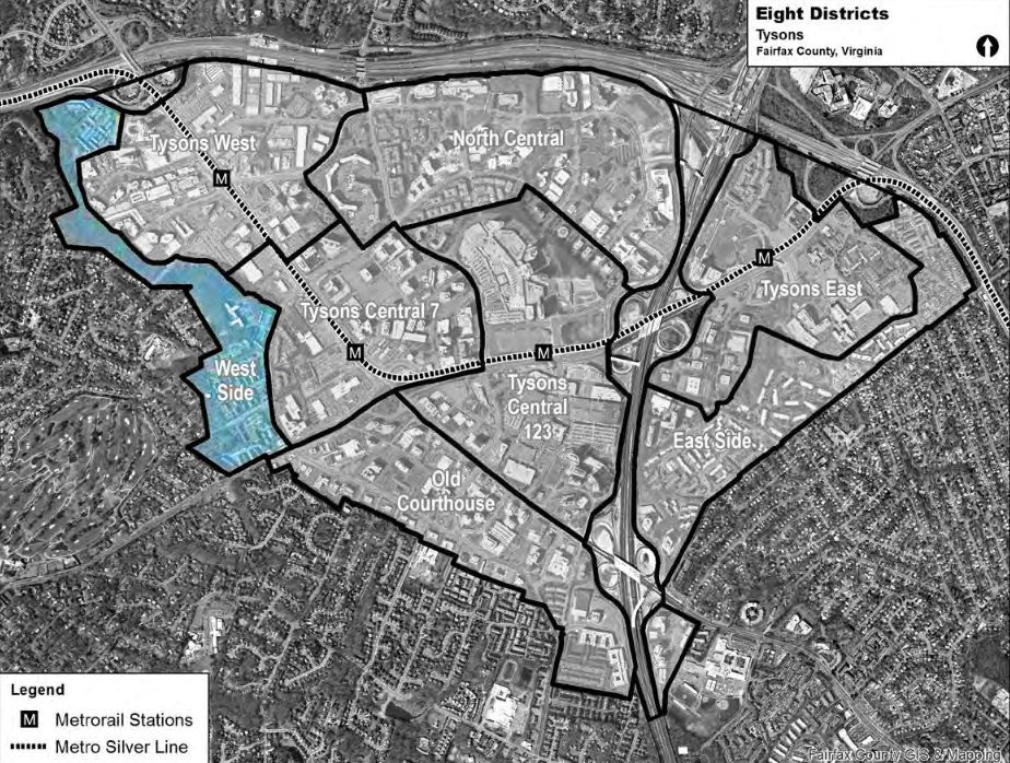
Tysons’ West Side is unique among its eight districts: most of it is parkland and two neighborhoods with no pressing need for redevelopment.
The park and these neighborhoods provide a clear transition between the soon-to-be shining towers of downtown Tysons West and the suburban neighborhoods beyond.
The Stream Valley Park
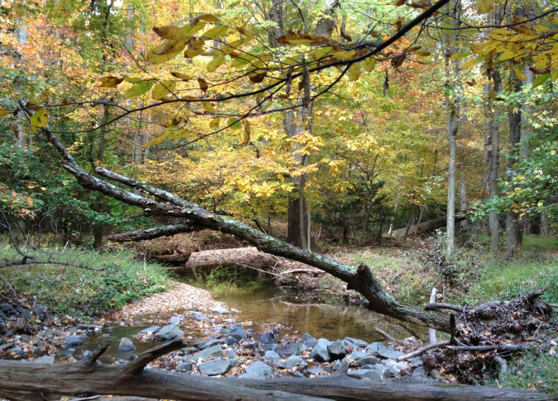
Some residents call it “Tysons’ Last Forest.” Its full name is Old Courthouse Spring Branch Stream Valley Park, adjoining Freedom Hill Park and Raglan Road Park, but it’s easiest to simply refer to the entire thing as the Stream Valley Park. It defines the West Side.
The park was created mostly in the 1970s, 1980s and 1990s as private landowners donated parts of the forest to Fairfax County. It includes Ash Grove, a historic site of some local significance that once belonged to the Lord Fairfax family.
It is an area of ecological significance. As the Neighborhood Coalition to Save Tysons’ Last Forest points out, the park “contains nationally-recognized ‘wetlands,’ which house the stream valley, a Palustrine forest of mature trees, and varied vegetation.” It provides animal habitat and, as part of the Difficult Run and ultimately the Chesapeake Bay watersheds, is important for stormwater management and for the region’s overall environmental water quality.
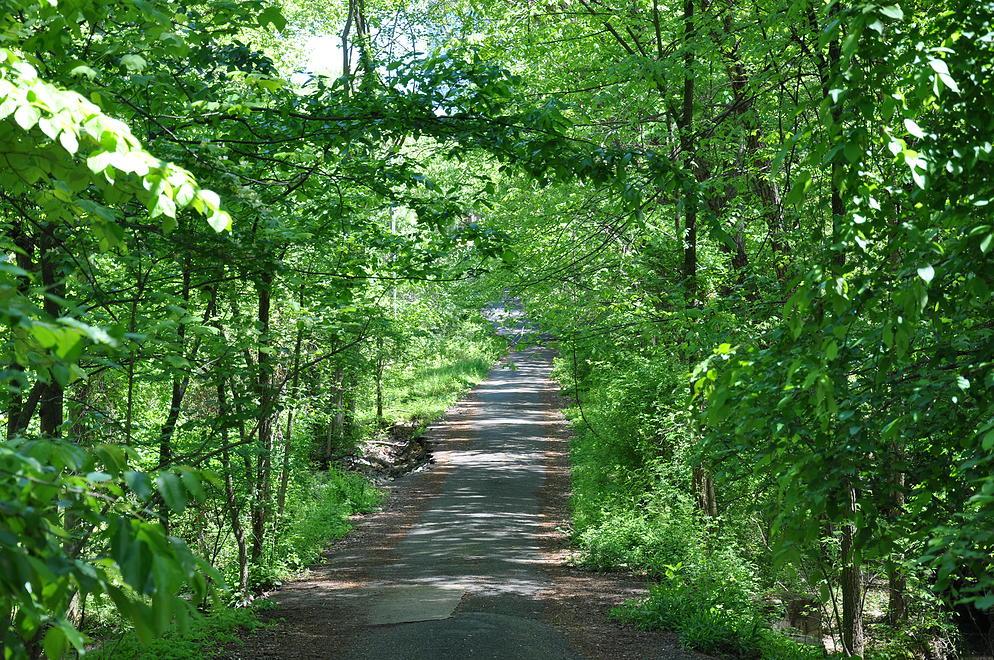
An active local environmental movement works to protect it from development — a movement which succeeded in preventing a highway ramp from being built in it. The only things that might disrupt the natural environment are bicycle paths, like the Vesper Trail that recently opened between Spring Hill Metro station and Higdon Road on the far side of the park.
Perhaps most importantly for residents, it also provides a natural urban green space. Less than a ten-minute walk from the Spring Hill Metro station, Stream Valley Park is accessible to residents of urban Tysons.
Gosnell and Ashgrove
The Gosnell and Ashgrove neighborhood seem like they will remain as peaceful, urban residential communities.
This pair of residential neighborhoods — Gosnell in the south and Ashgrove in the north — are communities of townhouses and multifamily structures that provide residential opportunities close to downtown Tysons’ employment centers and next to the natural amenity of the park. These residences were mostly built in the 1990s.
The Comprehensive Plan for Tysons found that, in fact, these neighborhoods already have the desired level of density. As such, they’re not slated for redevelopment anytime soon, meaning that this area is unlikely to change with anything near the speed or the intensity of other areas in Tysons.
Editor’s note: Over the next several weeks, Tysons Reporter is profiling the eight districts of Tysons. This is the seventh article in that series.
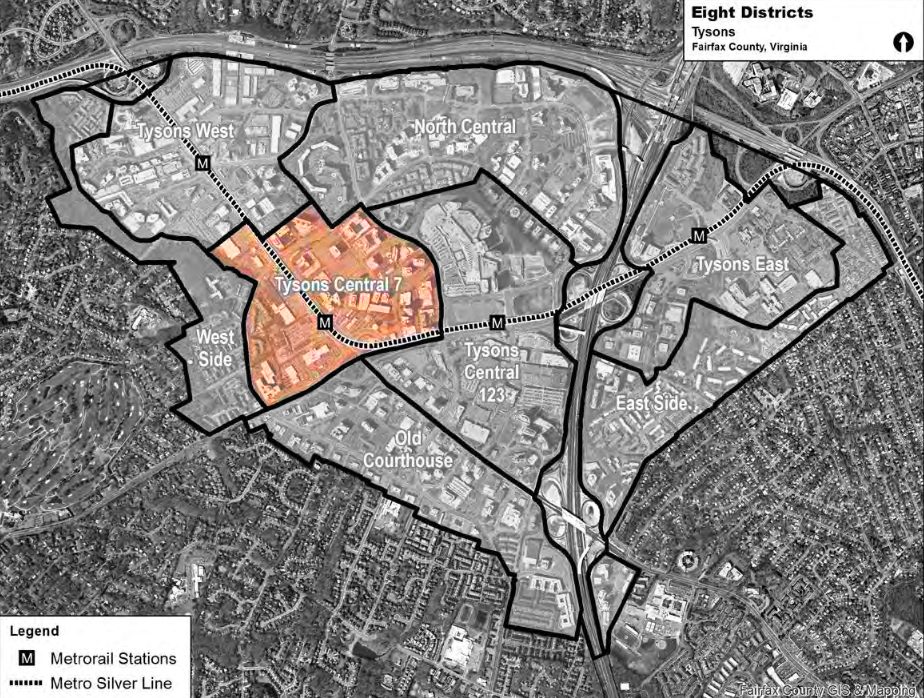
If Tysons Central 123 is Tysons’ Fifth Avenue, Tysons Central 7 is its Wall Street.
Anchored on the original “Tyson’s Corner” and the Greensboro Metrorail station, Tysons Central 7 is one of Tysons’ four downtown districts. It is the most similar to a conventional “Central Business District” elsewhere in the United States.
Northeast of Leesburg Pike, the district “will continue to have one of the highest concentrations of office space in Tysons.” Southwest of Leesburg Pike, planners intend a “Civic Commons” to be the heart of the Tysons community — but change might be slower here than in other downtown districts.
An Urban Downtown
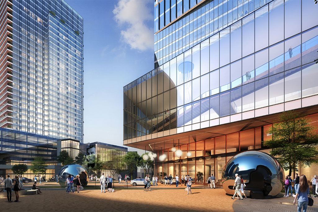
Tysons Central 7, named for the highway number of Leesburg Pike, is home to towers like 8100 and 8200 Greensboro Drive — modernist offices surrounded by lots of surface parking. It is also home to The Boro, a development opening later this year that consists of mixed-use high-rises surrounded by urban plazas and a new street grid. If the former represents Tysons’ past, and the latter represents Tysons’ present, both will leave their marks on Tysons’ future.
Predictions are that Tysons will grow to 200,000 jobs and 100,000 residents by 2050. Whether you think those predictions are conservative or generous, it is inevitable that the imbalance between jobs and residents will continue to be a major factor shaping Tysons’ development. Many of the new residences will be located in the districts like Old Courthouse that lie a little farther from the Metro, leaving the office pressure on the downtown.
Even as it diversifies with some retail, residences, and hotels to “become a vibrant 24-hour area,” Tysons Central 7 will continue to be defined by offices of all kinds, old and new.
Tysons Central 7 lies on what is naturally the most elevated land in Fairfax County, making it perfect for ambitious builders hoping to leave their mark on Tysons’ emerging skyline.
Editor’s note: Over the next several weeks, Tysons Reporter is profiling the eight districts of Tysons. This is the sixth article in that series.
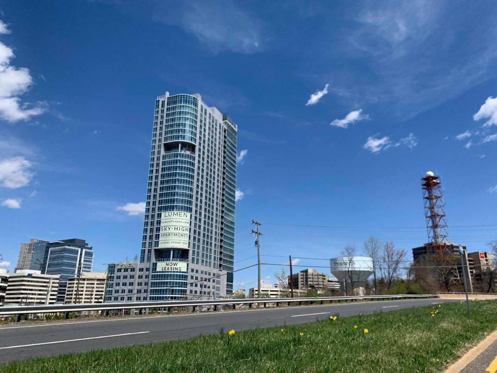
North Central, sandwiched between downtown Tysons and the Dulles Access Road, is in some ways the quintessential Tysons district, with neither the flash of a Metrorail station nor the moderating influence of surrounding suburbs.
It will remain a lower-density office option compared to the higher-density downtown districts, and will add some more urban residential neighborhoods along with a new park and a “circulator” transit option connecting it to the Metro.
North Central represents Tysons’ conventional approach to development in ways that other districts, with their Metrorail stations or surrounding suburban areas, don’t quite. Because it backs onto the Dulles Access Road, it is the only non-downtown district that is not required to provide a smooth transition to a suburban area. However, because it lacks a Metro station, it is not yet undergoing the kind of radically-transformative transit oriented development witnessed along the Silver Line. In some ways, the absence of those two factors make this perhaps the district where Tysons is most itself.
Plans for the area show a strip of office-only zoning along the fringe adjacent to the Dulles Access Road and the Beltway, with mid-density urban residential neighborhoods in the center and southwest of the district.
Circulator Will Connect to Metro
One challenge to urban connectivity in North Central is posed by the monumental Rotonda gated condominium community. The immense size of the two interlocking buildings, their position on a large hill, and the total lack of any sidewalk amenities adjacent to them, add up for an area that’s quite unpleasant to walk past. These buildings — though undeniably a striking contribution to Tysons’ urban milieu — are an obstacle standing between North Central and the urban amenities (Metro, performing arts, retail) in the nearby Tysons East district.
North Central faces another obstacle in its connection to the malls and Metro station of Tysons Central 123 — a steep uphill slope.
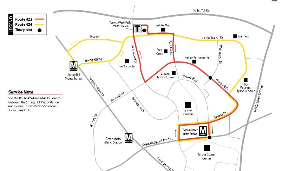
Fortunately, North Central is served by a technology capable of overcoming both of these obstacles: the humble bus. For only fifty cents, those residing in or visiting North Central can hop on a Tysons Circulator bus that will carry them to either the Spring Hill or the Tysons Corner Metrorail station. A bus from each line arrives every 12 minutes or so throughout the day, from early morning until midnight, helping North Central share in the value created by mass transit.
Although there aren’t specific plans in the works, Fairfax County expects to one day upgrade the line to higher-quality service or even to a streetcar or light rail system.
Development is Gradual and Ongoing
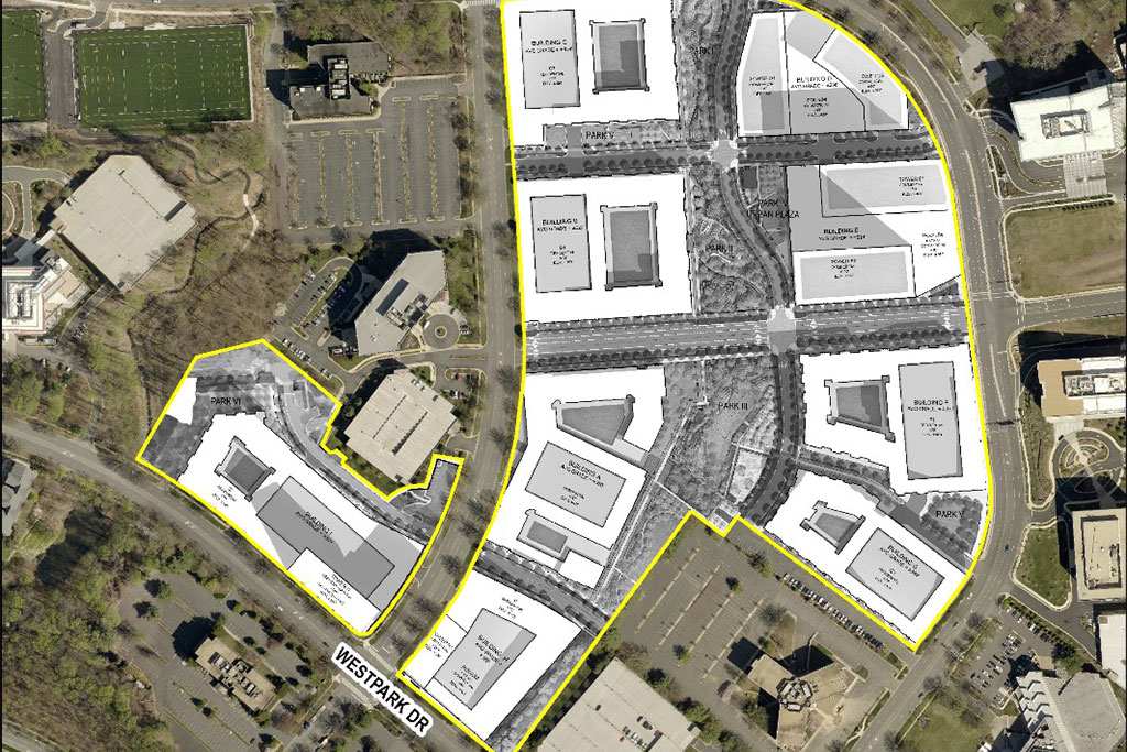
This district has seen its share of development in recent years. These include a luxurious four-building residential project at Park Crest, eleven floors of new class-A office space at Tysons Overlook, and the residential Highgate. In the near future, that last building could be joined by a 13-building mixed-use development called The Mile — if it is approved by the Fairfax Board of Supervisors at hearings in June and July of this year.
Development here is less frenetic than in the downtown districts, but it is ongoing at a healthy pace.
The Tysons Comprehensive Plan notes that, as circulator service is improved, greater residential density may become possible.
A New Park
A crowning ambition of this district could be the new urban park, 8-10 acres in size, to be created along Westbranch Drive and a future new street. This park, which would be one of Tysons’ largest, would include two athletic fields and provide “a focus for civic gatherings for residents and employees.”
However, one possible problem is that the provisional location of the park, as listed in the Comprehensive Plan, clashes with the proposal for development of The Mile. The Mile’s plan does include a large central green space, but it is not quite as large as Fairfax envisions, and does not include athletic fields.
The Comprehensive Plan also states that a new elementary school will be needed to accompany population growth in this area.
Editor’s note: Over the next several weeks, Tysons Reporter is profiling the eight districts of Tysons. This is the fifth article in that series.
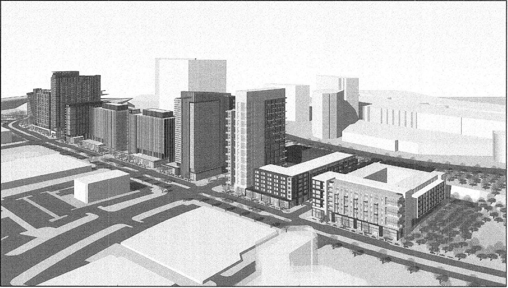
Tysons these days has a bit of a reputation as a cultural wasteland. Even today, that’s not quite true, and if the plans for Tysons West come to fruition it won’t be true at all.
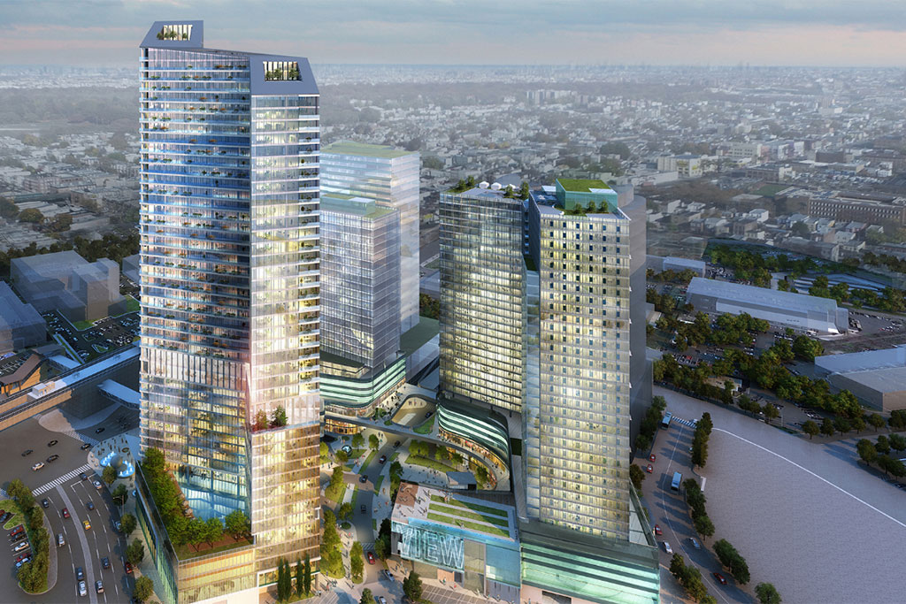
The Tysons Comprehensive Plan envisions this area, which is centered on the Spring Hill Metro station, as one of Tysons’ four downtown districts, an “arts and entertainment center.” The plan calls for a high-density diversity of uses, “tree-lined streets”, and “a series of urban park spaces.” Over 18 million square feet of development, including what could be Tysons’ tallest tower, is in the works, and much of it (though not yet the tower) has been approved.
From Car Dealerships to Towers
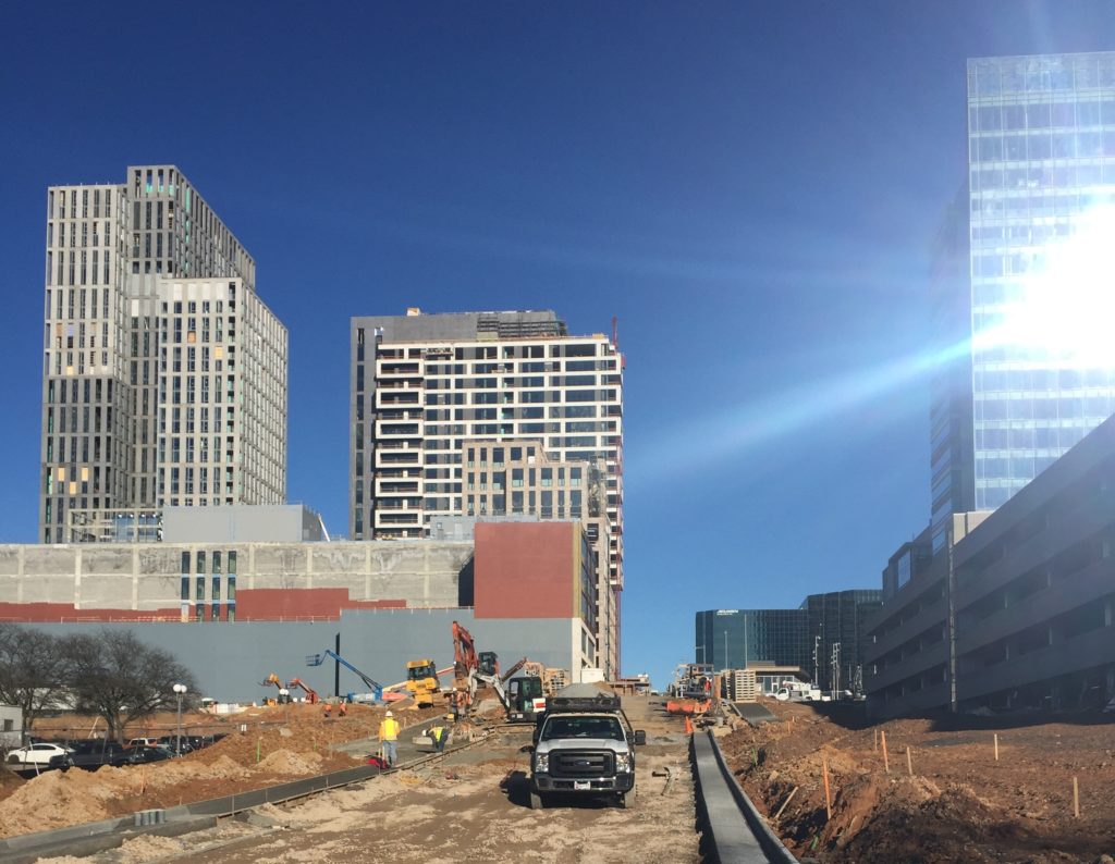
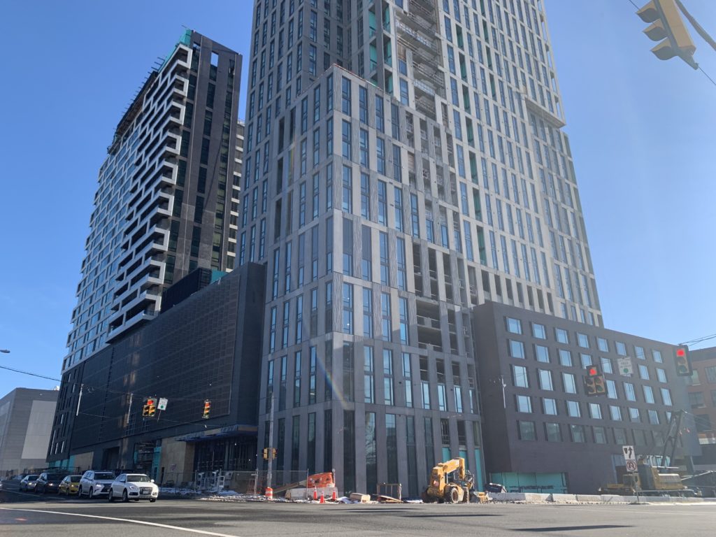
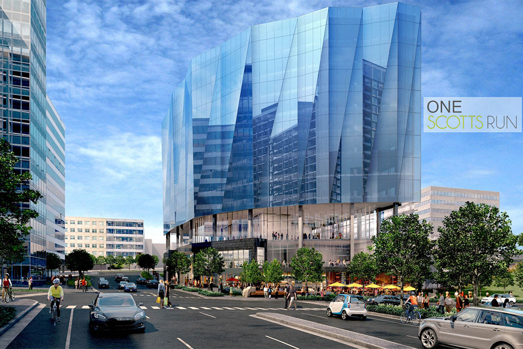
Today, Tysons West is the least developed of Tysons’ four downtown areas. Much of the land is still covered by car dealerships. But the arrival of a more urban form of transportation — the Silver Line — has sparked intense plans for redevelopment.
These plans, although by a range of different developers, share many elements that characterize projects across Tysons. They’re dense, mixed-use, and are built with an eye for pedestrian accessibility, meaning that residents should be able to fulfill daily and weekly needs without motorized transportation. They’re outward-facing, with most attention and retail activity on the sidewalks of public streets rather than inside buildings or isolated courtyards. And they connect to one another, through a new grid of streets, helping residents of one development enjoy the amenities of another.
Many of these projects also promise to bring sports fields, for example in Dominion Square East, or provide funding for fields nearby.
There’s so much new development slated for this area that I can’t even list it all, but naming a few key projects should give a sense of the scope of the plans.
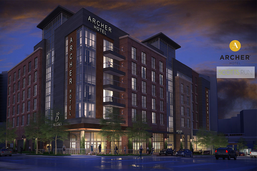
Dominion Square East, Dominion Square West, and Sunburst will all lie directly west of the Spring Hill Metro, within a five-minute walk. Combined, they will bring us at least 13 new buildings, as many as 3,100 residential units (20% of them to be designated for lower-income residents), over 200,000 square feet of commercial space, and several office towers. The Vesper Trail, which opened recently, passes through this area to connect to the Metro.
Editor’s note: Over the next several weeks, Tysons Reporter is profiling the eight districts of Tysons. This is the fourth article in that series.
For those seeking a calmer but still urban lifestyle within a short walk of parks and of the emerging downtown Tysons, the East Side might be your best bet — and that will only become more true as the Tysons Comprehensive Plan is implemented.
The East Side extends along the eastern fringe of Tysons, from Route 7 in the south to the Dulles Access Road in the north, bounded by Magarity Road in the east and Tysons East to its west. Today, it’s mostly composed of garden-style apartment developments like Tysons Landings and the Dolley Madison Apartments.
Over the next few decades, it will remain primarily residential, forming a smooth gradient of transition from downtown Tysons to single-family Pimmit Hills. It will not witness rapid increases in density like Tysons East, but rather it will gradually take on a more urban character. That means neighborhood retail, like corner stores and local restaurants, and it means a more cohesive and walkable network of streets.
The district might include some offices, which planners hope to configure into a “live-work” combination — imagine the 21st-century equivalent of a craftsman living upstairs from his shop.
Park Connections
This district is closely tied to Tysons East, and in a way it is the residential backyard to that district’s vibrant center. Right now, the two are separated by a forest, the Scotts Run Stream Valley Park, that can make it difficult to get from one to the other.
This year, though, Fairfax County will be taking the first steps to change that park from a barrier to a gateway, building pedestrian and bicycle paths to connect the East Side to Tysons East through one of Tysons’ greatest natural treasures.
Getting Around
Most of the East Side is only a short walk away from the McLean Metro station, and that walk will become significantly easier – and more pleasant — with the opening of the Scotts Run Trail. The 3T bus on Magarity Road offers reliable and comfortable service to downtown Tysons and to the center of Falls Church.
However, right now it is remarkably difficult to walk from anywhere on the East Side to downtown Tysons. That will soon change, though, with the construction of a new pedestrian and bicycle bridge over the Beltway. The bridge will link the East Side directly with Tysons Corner Center and contribute to a more complete network of access throughout the area.
The Comprehensive Plan calls for a circulator system of public transit to span the entirety of Tysons, and although its precise location is still in question, the Plan indicates that it will likely be placed along Old Meadow Road.
Gradual Development
In stark contrast to nearby Tysons East, which is slated for near-total redevelopment in the next few years, the East Side will see change come more gently — or, at least, in the farther future.
The only project currently on file is a new hotel, and even that is located in the extreme southern part of the East Side — its only office-focused corner. Just because change is coming more slowly, though, does not mean it will never come.
Editor’s note: Over the next several weeks, Tysons Reporter is profiling the eight districts of Tysons. This is the third article in that series.
Almost three hundred years ago, when Thomas Fairfax was still alive, the county’s first courthouse was built where the “Toilet Bowl Building” now stands. The courthouse is long gone, but it has given its name to the second of Tysons’ eight districts.
“Old Courthouse” is now home to mid-rise offices, but is destined to become a mixed-use residential quarter as the Comprehensive Plan is implemented.
Ironically enough, the Old Courthouse district doesn’t actually include the land where the courthouse itself once stood. Rather, the district runs along Old Courthouse Road and Gallows Road and is bounded by Route 123 to the northwest, Route 7 to the northeast, the Beltway to the east, and the single-family neighborhoods to its south and southwest.
Old Courthouse is today home to a collection of low- and mid-rise office buildings and a few strip-mall-style retail and dining options. Tomorrow, it could be home to many more people.
The Tysons Comprehensive Plan envisions this area as “a neighborhood that supports an active 24-hour environment where people go to restaurants or shopping after work.” and where “residential development will become a dominant use in most subdistricts, which will create the sense of community throughout this district.”
In a sense, this will be the residential counterpart of the Tysons Central 123 shopping area just north of it.
Getting Around
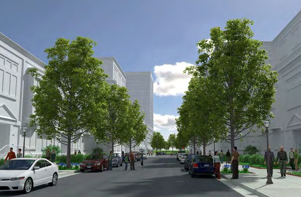
As a mixed-use residential area, planners intend for families living in Old Courthouse to be able to satisfy most of their day-to-day needs with a short walk. Pedestrian infrastructure, like more pleasant sidewalks and safer crossings, will help make that vision a reality.
Perhaps the most major change in the blueprints for Old Courthouse is the extension of Boone Boulevard. Ultimately, this street could triple in length, extending all the way from Kidwell Drive in the south, crossing Route 123 in the north, and leading into the civic center planned for the western part of Tysons Central 7. That extension — along with other proposed new streets perpendicular to it — would create a denser grid of streets, making it easier for both pedestrians and vehicles to move around.
Public transportation will be key to the district’s future. Almost all of Old Courthouse is within a mile walk of the Greensboro Metro station, and some is much closer. The extended Boone Boulevard has been identified as a prime candidate for a circulator line connecting the different neighborhoods of Tysons.
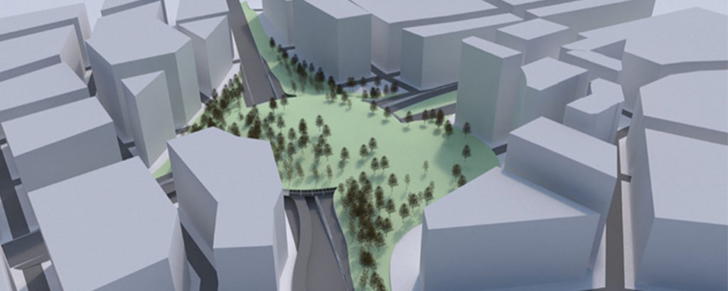
Old Courthouse also stands to benefit greatly from the potential park on top of the Route 123-Route 7 intersection, which would make it much easier for people to get to the Metro station as well as provide some much-needed green space.
Redevelopment Projects
Although the vision of the Comprehensive Plan extends for decades, a handful of development projects in the coming years offer us a peek into the future of Old Courthouse.
For the most part, developers will be permitted to construct offices and shops in addition to residences throughout Old Courthouse. However, Fairfax County hopes to incentivize additional housing by letting developers build taller buildings if those buildings are residential — with the requirement that these taller apartment or condo buildings have a light impact on traffic.
In 2015, Fairfax County approved plans for a development including 385 apartments and 129,000 square feet of commercial space to be located in the northern part of Old Courthouse on Rt. 7. This plan, called International Place, would bring a much more urban form, with wide sidewalks and street cafe seating. However, the developer who was to be responsible for the project has since declared bankruptcy, leaving the undeveloped-but-approved project on the market.
A hospital could also be coming to the eastern part of the district as the medical system seeks to be able to serve the increasing number of residents across Tysons.
Editor’s note: Over the next several weeks, Tysons Reporter is profiling the eight districts of Tysons. This is the second article in that series.
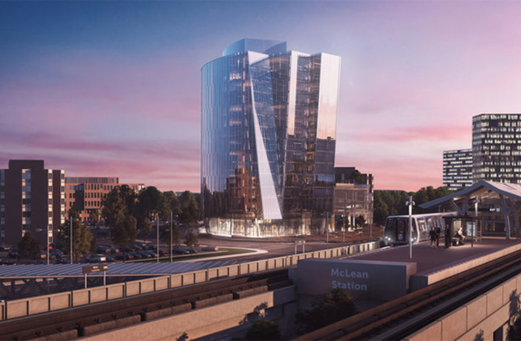
Arriving at the McLean Metro station today, your first impression of Tysons is a construction zone — impressive, perhaps, though not the most inviting. But, sooner than in most other districts, “America’s Next Great City” will be rolling out a verdant welcome mat and transforming Tysons East into an urban park and a vibrant gateway to Tysons’ downtown.
Tysons East, one of Tysons’ eight districts and one of its four “downtowns,” is the area around the McLean Metro station. It already holds the Capital One tower, which is the tallest building anywhere between Baltimore and Richmond. That won’t be the last tower to pop up in the district: the aptly-named One Tysons East will soon be joining it.
Each of the four downtown districts has a specialty. Tysons Central 123’s two malls make it a shopping paradise, Tysons Central 7 is already known for its high-powered offices, and Tysons West is slowing developing a cultural scene.
Tysons East — though a mixed-use urban environment with plenty of offices, shops, and residences — will be characterized by two unique attributes. First, plans are in the works to improve and extend the Scotts Run Stream Valley Park, making this into the greenest corner of downtown Tysons. Second, planners envision Tysons East as home to public uses, like educational institutions, that would make it a hotspot for the creative class.
Trees and Towers
One of the greatest failures of past generations of urban planners in Fairfax was their failure to preserve nature. This generation of planners is trying their best to regain the park space that was lost, planning reclusive gardens and natural spaces as a nearby retreat from the chaos of downtown Tysons.
In Tysons East, they’re working with the Scotts Run Stream Valley Park, a half-mile-long strip of dense forest extending south from the McLean Metro. Although today it’s fairly uninviting, without designated trails or other recreational facilities, there are plans in the works for it to become a beautifully-landscaped public green.
This new park will also function as a connector, with pedestrian and bicycle paths to join the residential neighborhoods of the East Side to the bustling downtown of Tysons East. In fact, the first pedestrian path, from Magarity Road to Coleshire Meadow Drive, should be under construction in the next few months.
The Tysons Comprehensive Plan envisions that, as redevelopment progresses, the park will “be expanded through the stream valley and in adjacent areas to provide better access and connectivity throughout the Tysons East District.”
“It will provide a range of experiences, such as enjoying the outdoors and scenery, arts, performances and programs or participating in recreation,” the plan says. “Intimate gardens with shady places of retreat could provide relief and gathering places for families, visitors and workers in Tysons.”
Dave Whitman is a principal at SmithGroup, the planning and urban design consultants responsible for the Scotts Run development that will redefine Tysons East. He explained that the Scotts Run park will contribute much more than a name to the development — it will shape the area’s urban visual identity.
“Elements from Scotts Run such as water, vegetation, wood, and stone will be incorporated into the design of the public spaces and streetscape throughout the project,” he said.
Institutional Ambitions
One defining feature of the Comprehensive Plan’s vision for Tysons East is institutional. The Plan states that “public and institutional facilities such as professional education, recreational, health and sports amenities should be located in this district.” By emphasizing the educational and recreational role of the district, planners hope to make it a more diverse and desirable residential area.
However, the Comprehensive Plan doesn’t actually include specific plans to incentive these kinds of institutions, and current redevelopment plans — which cover most of the district — do not seem to include such uses, except for some athletic fields.
Editor’s note: Over the next several weeks, Tysons Reporter is profiling the eight districts of Tysons. This is the first article in that series.
Tysons Central 123 is the commercial heart of Tysons. Residential towers, tree-lined boulevards of storefronts, and perhaps a convention center will catalyze the continued success of this retail district as the Tysons Comprehensive Plan is carried out.
Tysons Central 123, named after Route 123, contains over half of Tysons’ retail floor space. Almost all of that retail is concentrated in the two enormous malls that define the neighborhood: Tysons Corner Center, south of Chain Bridge Road, and Tysons Galleria, north of it. Combined, they make the district a regional shopping destination.
As it stands, Tysons Central 123 is a major shopping destination — but very little else. That was a successful approach when Tysons was only a suburban mall, but now changes are in the works.
The district’s section in the Tysons Comprehensive Plan calls for it to evolve into a full-fledged neighborhood. That means tree-lined boulevards rather than congested highways, it means mid- and high-rise buildings rising around the malls, it means more retail at street level, and it might mean a convention center.
Fifth Avenue in New York isn’t only a shopping destination. It also offers cultural destinations, a pleasant outdoor streetscape, and a large residential community. All of these will increasingly appear in Tysons Central 123, supplementing the shopping rather than detracting from it. Retail will continue to define the neighborhood.
“This district is envisioned to remain the region’s signature shopping destination,” states the Comprehensive Plan.
Hills and Valleys
One particular feature of the Tysons Central 123 district is the steep topological slope down from Tysons Drive to Westpark Boulevard. Planners see this challenge as “an opportunity to integrate the district with the adjacent North Central District” through “terraces and plazas” that could provide a unique character to the surrounding neighborhood.
Getting Around
Today, the area has strong transportation options: the Tysons Corner station of the Silver Line anchors the center of the district. The transit center there is served by eight different bus lines, more than any other point in Tysons, connecting to destinations near and far. However, with increasing density, existing challenges for mobility will become more pronounced.

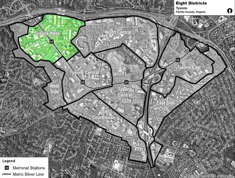
Tysons is larger than many people realize.
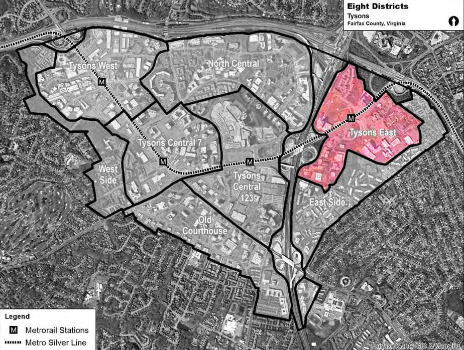
The triangular area under Fairfax County’s Tysons Comprehensive Plan extends from Magarity Road in the east to Raglan Road Park in the west, with its southern tip just north of Marshall High School. That’s about 3.3 square miles or 2,100 acres — larger than the area between the Lincoln Memorial, Union Station, and the Wharf in D.C.
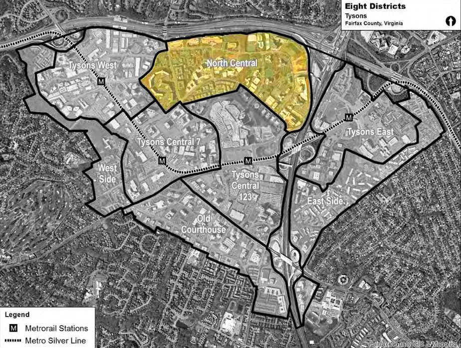
It’s difficult to even talk about such a large area, much less plan for it, as a single entity. D.C. has its famous quadrant system, Paris has its twenty arrondissements, and Tysons has eight districts.
Fairfax’s award-winning 2010 comprehensive plan for Tysons is clear that “the transformed Tysons will be organized around eight districts, each with a mix of land uses.” That is to say, these aren’t zones that each exclusively focus on one activity — rather, each district will include residences, workplaces, shopping, recreation, and civic centers. Ultimately, the vision is for eight neighborhoods, each one supplying everything needed for daily life.
The planning for these districts also envisions specialities for each one, emphasizing different ways they can contribute to Tysons’ urban mix. No neighborhood will be a single-use zone, but they will nonetheless have certain specialties.
Visually, the districts are simultaneously continuous and distinct. Although there are clear boundaries on a map, those boundaries won’t be apparent in reality.
“Each district will be connected to the others,” the plan says. “Boundaries between the districts will be blurred as people move seamlessly from one place to the next.”
These eight districts have their own identities. The comprehensive plan “encourage[s] design elements that highlight the distinct character of each district,” largely through parks, plazas, and other public spaces but also through streetscape design, architecture, and land uses. In the same way that Capitol Hill and the Washington Navy Yard feel clearly different, planners hope that each neighborhood of Tysons will be unique.
It’s worth noting that, although Fairfax has provided provisional names to the neighborhoods, they’re not always the most user-friendly — and the county “may consider modifying the district names” as identity formation progresses.
In a series of upcoming articles, linked as they become available, we’ll examine each of the districts in detail. For now, we’ll leave you with a quick overview.
Transit-Oriented Districts
The first four of the districts each correspond to a station on the Silver Line. These districts, combined, are expected to account for 75 percent of future development and “will resemble intense and busy downtowns.”
- Tysons West and the Spring Hill Metro station will welcome those arriving from Reston and beyond. It is “an optimal location for an arts and entertainment district, including restaurants and entertainment options that stay open after the workday ends.”
- Tysons Central 7 and the Greensboro Metro are envisioned as business-focused, with a high concentration of office space, but also “a civic center with a mix of public, residential and commercial uses.”
- Tysons Central 123, with two malls and the Tysons Corner station, is and will remain “the region’s signature shopping destination.”
- Tysons East and the McLean Metro station will be the eastern gateway of Tysons, defined by Scott’s Run, which is “envisioned to transform into a great urban park surrounded by mixed use development.”
Non-Transit-Oriented Districts
The four remaining districts are farther from Metro stations and are envisioned as transition zones leading into the nearby neighborhoods. They contain some “areas that should maintain their existing characters, uses, and intensities.” However, just because they’ll be less dense than the preceding four doesn’t mean they won’t be urban — most of these areas are already as dense as much of D.C. and most lie within a 10-15 minute walk of Metro.
- The West Side will continue to be a primarily residential neighborhood, with natural amenities and close proximity to the Metro corridor.
- Old Courthouse, in the southwestern part of Tysons, is expected to develop a wider range of neighborhood-serving retail and restaurant options while it functions as a transition zone between the core of Tysons Central 123 and the surrounding residential areas.
- North Central, sandwiched between the Dulles Airport Access Road and the center of Tysons, is expected to see the continuing development of urban neighborhoods like The Mile.
- The East Side, with investments in connectivity like a pedestrian bridge over the Beltway, will form a primarily residential community smoothly connecting Tysons to Pimmit Hills. These residences will be supported by local retail and live-work opportunities.