The crossing of Chain Bridge Road and Leesburg Pike — where Mr. Tyson’s fruit stand stood eighty years ago — could soon see some major changes.
Right now, that intersection is an elevated partial cloverleaf interchange, the way it’s been since at least 1980. But it could become a new kind of intersection and a new kind of public space.
A few years ago, Tad Borkowski of the Fairfax County Department of Transportation was assigned to study the possibility of widening Leesburg Pike (Route 7). He found that the existing interchange would prevent that from ever happening: the tunnel under Chain Bridge Road (Route 123) was too narrow to ever accommodate a wider passage, he told Tysons Reporter.
The interchange had another problem, too. It wasn’t in its natural environment. It had been constructed for a much more rural place — at the time, most of the area considered today to lie within Tysons’ eight districts was still forest.
Now, Tysons has urbanized. Routes 7 and 123, which were once freeways, have been bogged down in a series of traffic light intersections on all sides of the interchange. The traffic bottleneck is no longer that crossing; now, it’s the rest of Tysons.
That means that the traffic efficiency gained by a partial cloverleaf is pretty much lost anyway — it doesn’t do anyone any good to cruise through the interchange when they just hit a red light at International Drive right afterward.
Also, as Tysons urbanized, land became much more valuable. In the 1970s, that land was cheap to build ramps on. Now it has higher and better uses.
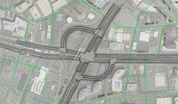
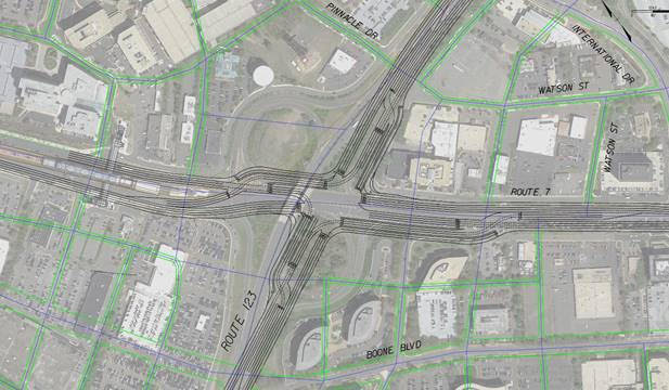
Burkowski’s office has started to look into improved set-ups for the intersection. Specifically, they’ve focused on two possibilities — a “two-quadrant” option and a “continuous flow intersection” (CFI) option. There are some technical differences between the two, but they both amount to the same basic idea. They both give drivers a way to take left turns without blocking oncoming traffic, which dramatically increases throughput. This YouTube video gives a quick, intuitive explanation.
Burkowski examined both possibilities for the intersection under simulated conditions for the year 2050, assuming a denser grid of surrounding streets (this dense, urban grid is a critical element of the Tysons Comprehensive Plan) and increased numbers of vehicles — but not considering the possible effects of autonomous vehicles.
Both options provided very similar traffic throughput results. Both options also provide opportunities for constructing a bus rapid transit line along Route 7 through the intersection, in keeping with ongoing plans.
The two-quadrant approach takes up a wider space — though still smaller than the existing interchange — but offers some advantages in pedestrian safety by allowing people to cross the intersection step-by-step.
As Tysons becomes more and more dense, pedestrian mobility is increasingly valuable. Burkowski, though, is confident: “We don’t want to mix pedestrians and cars at all.”
First, at speeds like those on these major arteries, the road simply is never a safe place for a human body. Second, including a pedestrian phase in the traffic signals would slow car throughput to unacceptable levels. Finally, third — there is an alternative.
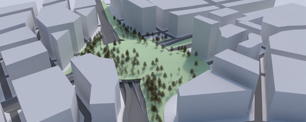
The Fairfax DOT is considering the concept of building pedestrian space over the new intersection. Because there won’t be any vehicle ramps, cars will stay at ground level – letting pedestrians take the air above them.
This pedestrian space could be a lot more than just a bridge. Prioritizing connectivity, it could be a cap, reaching all across the intersection and converting it into park space – even into a kind of “central park” for Tysons. It could also be a series of bridges with an elevated central plaza, connecting not only to the four corners of the intersection but also directly to the Greensboro Metro station only 800 feet away.
The goals are ambitious. The Fairfax DOT’s first stated goal is to “create Tysons’ focal point,” bringing a sense of civic centrality to a place that has never quite had one.
The Tysons Urban Design Guidelines, though, have a different vision for these thoroughfares, which it envisions as boulevards, saying “above-grade skybridges or below-grade pedestrian tunnels are strongly discouraged as they detract from the vibrancy of the streetscape.” Even with the elevated plaza concept, though, Fairfax DOT would prioritize “connect[ing] ground floor spaces with programmed open spaces.”
Borkowski ended a conversation with Tysons Reporter with the reminder: “This is all very high-level, and nothing has been designed yet.”
Many, many details have not yet been considered, and the possibilities in this article are still nothing more than that: possibilities. Still, the Fairfax DOT does intend to narrow down its options and to move forward in meetings with the Tysons Partnership and other stakeholders within a year.
Recent Stories

Joon has expanded its offerings in Tysons with the addition of a bar and patio. Named after a poetic Farsi term for “wine,” May Bar began serving customers inside the…

Owners of six Woofie’s franchises in Northern Virginia are hosting a “Paws in the Park” pet adoption event tomorrow (Saturday) at Wolf Trap National Park. Participating Woofie’s include Reston/Herndon, Ashburn-Leesburg,…

A Fairfax Connector bus to Tysons (staff photo by James Jarvis) The Fairfax County Department of Transportation (FCDOT) has the green light to apply for a federal grant to replace…

The country band Delta Spur performs on the Plaza at Tysons Corner Center for the mall’s 2023 summer concert series (courtesy Tysons Corner Center) Fresh produce, good dogs and live…