
HQ2 Worries for Fairfax Companies — “Amazon.com Inc.’s move to open a second headquarters in Arlington may prove to be a mixed-bag for Fairfax County. While many HQ2 employees are expected to live in the county, there’s a real chance that Amazon (NASDAQ: AMZN) will take tech talent from companies based in Fairfax.” [Washington Business Journal]
Does Tysons Need New North-South Transit? — “The Silver Line is good for east-west, but Tysons needs something north-south too. [Twitter]
Silver Line Station Progress — “Work crews in yellow vests and hard hats continue to dot the stations, track, pavilions, pedestrian bridges and tracks along the Phase 2 alignment, but over the next few months, more and more of those workers will be heading to interior work stations to run utility lines, install equipment and test all of the facilities.” [VivaTysons]
Apartment Fire in Falls Church — A fire broke out in the kitchen of an apartment at 450 N. Washington Street in Falls Church on Friday afternoon. [Twitter]
Falls Church PD Seek Info in Dog Bite Case — “City of Falls Church Police and Animal Control are looking for a dog that bit a man on the leg on Wednesday, March 27, around 2:15 p.m. near the Cherry Hill Park tennis courts.” [City of Falls Church]
")
The Fairfax County Department of Transportation (FCDOT) is looking for some public input on new trail names for the bicycle and pedestrian path along I-66.
No Traily McTrailface, please — FCDOT is seeking a more pleasant, non-gimmicky monicker for the trail, which is currently in planning but set for construction later this year.
“The concern was that I-66 has a negative connotation because everyone hates I-66,” Chris Wells, bicycle and pedestrian program manager for FCDOT, said at an earlier meeting. “But everyone knows where I-66 is and where it’s located. We’re going to be doing sample names and present those at a future meeting.”
The trail — will run from Gallows Road in Vienna to Centreville — has more problems than just the name. Discussion of the I-66 trail at that meeting turned contentious as bicycle advocates prodded Virginia Department of Transportation (VDOT) staff over issues like separation of the trail from the road and snow removal.
For most of the length of the trail, the bicycle path will be at a separate elevation from the highway or running parallel on side streets.
For a few miles, particularly near Vienna, however, the trail will be running directly alongside the highway. VDOT officials at the meeting noted that it was “not ideal for a pleasant bike-riding experience,” but placing the trail on the other side of the sound barrier would have cut into the back yards of homes along the road.
Upcoming meetings are planned to review the proposed trail and offer an overview of the upcoming construction timeline. The two meetings are scheduled for:
- Vienna: Tuesday, April 9, from 7-8:30 p.m. at Marshall Road Elementary School (730 Marshall Rd SW)
- Centreville: Saturday, April 27, from 1-11:30 a.m. at Centreville Elementary School (14330 Green Trails Blvd)
According to a Department of Transportation post for the meetings:
The meeting will also include an interactive exercise with attendees to explore possible names for the new trail. Attendees will be asked to submit names and weigh in on a sampling of names that have been suggested. FCDOT will than narrow the list of names and host an online survey to vote on the trail names to be presented to the Fairfax County Board of Supervisors and Virginia Commonwealth Transportation Board for consideration and approval.
Image via VDOT
")
Fairfax County thinks you might need some additional reminders about how quickly you’re driving.
At a Transportation Committee meeting on Tuesday, county staff unveiled plans to initiate a pilot program to install new pole-mounted speed display signs.
The signs will track data on cars driving on roads with high levels of speeding, while displaying the speed of passing drivers.
The pilot program will run for one year, with four signs purchased. Two signs will be posted at locations around the county, one facing in each direction, and over the year they will be rotated so each district has the sign at least once.
The signs will be posted at each location for six weeks total, with four weeks of being active with one week dark before and after to collect data on whether the signs have an impact on speeding.
Supervisor Pat Herrity noted that the signs would help the County track data for speed studies. Following inquiries, staff reaffirmed that the signs would not take photos of speeding cars or track license plates.
Dranesville District Supervisor John Foust noted that approaching the installation as a pilot project seemed redundant, since it’s a well-established technology used by other jurisdictions.
“It seems to me like we’re reinventing the wheel in a lot of ways,” said Foust. “These things have been around for a long time, and we’re treating it like we have to study this or analyze that. We need these things. They work.”
Supervisor Dan Storck was similarly dubious of staff’s assertion that there was limited data on the effectiveness of the signs, given that Arlington County has installed similar signs.
While the current plan is to continually rotate the location of the signs, Foust said the County will likely be able to identify problem areas where the signs will likely need to be put up and left.
Photo via Flickr/Loozrboy
")
Dockless electronic scooters are coming to Fairfax County.
Lime scooters will soon be released on the streets of Vienna, Merrifield and Falls Church, according to a press release.
“We’re thrilled to expand our footprint in the DMV area and to begin serving Fairfax, providing accessible, affordable mobility options to riders across the city,” Sean Arroyo, Lime’s regional general manager, said in a press release. “We couldn’t be more excited to integrate ourselves into the community and to begin working with local leaders to help achieve their sustainability and accessibility goals.”
Users can use the Lime app to locate the nearest scooter, then scan the QR code on the handlebars or baseboard to use it. Users are encouraged to ride in bike lanes and wear helmets.
Scooters cost $1 to unlock and 15 cents per minute to ride. Rides are finished in the app to be parked at a street curb or bike rack. Riders must be 18 years or older.
E-scooters are popular in major cities D.C., and are already ubiquitous in close-in suburbs like Arlington, but the hoards of abandoned scooters left haphazardly strewn across the streets has also drawn some criticism or even dramatic acts of vandalism.
In addition to Vienna, Falls Church and Merrifield, Lime says it is also bringing scooters to George Mason University and the City of Fairfax.
Photo via Facebook
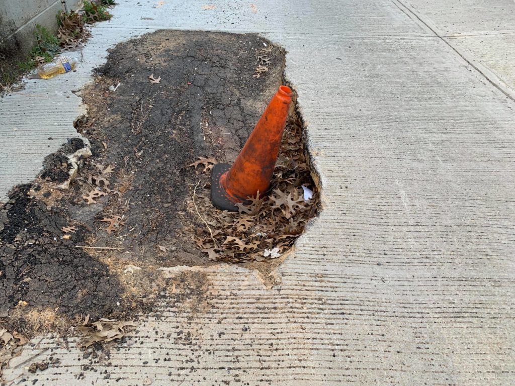
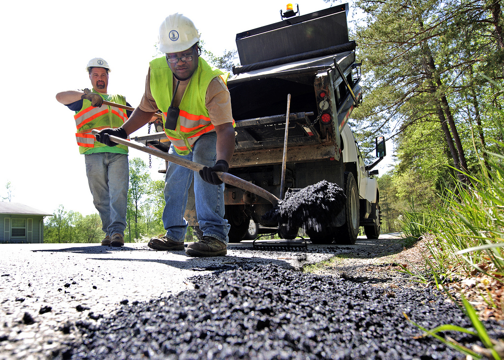
If the roads have seemed a little rougher than normal, it’s not just you.
According to the Virginia Department of Transportation (VDOT) officials at a meeting earlier this month, the past year has been one of the worst years on record for potholes. The pothole problem is also prevalent in D.C.
According to Allison Richter, liaison to Fairfax and Arlington counties for VDOT, fewer than half of the secondary roadways are in good condition. For 2018, interstates were 86 percent in fair or better condition — down from 93 percent in 2016. But secondary roadways were assessed at only 41 percent fair or better condition, an improvement from 2016 but still bumpy for drivers.
“This is possibly the worst year for potholes that I’ve seen,” said Richter.
Richter said many roads throughout the area qualify for paving, but VDOT hasn’t been able to get to all of them. Road repaving is based not just on the condition of the pavement, but on traffic volume, whether the whole neighborhood can be repaved, and various costs.
“Paving funding has gone up and down,” said Richter. “We’re behind, it’s why so much is in the red.”
Total repaving funding for Northern Virginia over the last decade has grown from $58.1 million in 2013 to $140.9 million in 2018, but in 2019 it dipped back down to $105.9 million.
While Northern Virginia generates a disproportionate amount of tax revenue compared to the rest of the state, Richter said road funding is one area where the region uses proportionately more funding than other parts of the Commonwealth.
")
In addition to years of repaving neglect, Richter said the pothole situation is the result of record high rainfall and dramatic temperature swings.
Richter said repaving is scheduled to get started this month once temperatures are warm enough.

Traffic is not inevitable, and new development does not have to bring new cars.
Arlington County saw an astounding decline of 20 percent in average weekday traffic in just 15 years from 2000 to 2015. That same period saw a growth of nearly 20 percent in population. Certainly, many of Arlington’s new residents drove cars — but not all, and some of its long-time residents must have found new ways to get around.
There are several ways to fight congestion. Most people’s first thought is simply to widen the road. More road, more space for cars, less traffic — right? The problem is that it won’t work for long.
For economists, mobility can be a commodity like any other. And when the government gives something away for free — in this case, it’s giving away the use of asphalt — of course people will clog the system. When something is available for free people will wait in line, paying with time instead of money. So, if highway engineers widen the roadway, it’s only a matter of years until more cars come along and the traffic is as bad as it ever was.
Another idea might be to slow down new development — but it would be difficult to persuade Fairfax County to forgo all the additional tax revenue.
Third, the county could turn to public transit. The Metro arrived in Tysons in 2014 and, while ridership is increasing, it still lingers below expectations. It was certainly a step in the right direction, but Metrorail was a major investment, and it will take decades of development and improvements to local bus service and sidewalks before it sees full results.
Wider roads, slowing development, and railways are 20th-century solutions. The 21st century brings a more subtle, smarter approach — an approach that professionals call “transportation demand management.”
Transportation demand management is not a single technique, but a set of approaches that nudge people out of their cars and towards buses, bikes, walking and working remotely. It’s practiced cooperatively by Fairfax County, the Tysons Partnership and private developers. It often relies heavily on data-driven, highly connected approaches rather than on large infrastructure investments.
One example of a transportation demand management program is the “Guaranteed Ride Home” offered by Fairfax County. This program offers commuters a free trip home up to four times every year. It’s intended for those who would consider a new kind of commute, but who the fear of unplanned overtime or family emergency keeps tethered to their cars.
What Developers Are Doing
For a clearer understanding of what individual developers are doing to cut congestion, Tysons Reporter spoke with Caroline Flax of The Meridian Group, the master developer of The Boro.
Flax described the “pedestrian experience” at The Boro, and the options that will be available to people on foot. By locating residences close to offices, retail, restaurants and Metro stations, Meridian hopes to “create a bite-sized pedestrian experience.”
“We will have a pedestrian-only promenade that connects to Boro Park, and for the other streets we have created wide sidewalks with activated outdoor seating that will create a really inviting pedestrian experience,” she said.
According to the EPA, concerned with carbon emissions from cars, “Research consistently shows that neighborhoods that mix land uses, make walking safe and convenient, and are near other development allow residents and workers to drive significantly less.”
“[Transportation demand management] is about promoting the other transit options available to residents, visitors, and tenants — aside from driving,” she said. Those options include bicycles, buses, and trains.
Caroline emphasized “making [The Boro] accessible in general” — including shared office/commercial parking to efficiently accommodate drivers, wide sidewalks for pedestrians, designated bike parking, Capital Bikeshare, and creating options for easy pick up and drop off by ride-hailing companies like Uber and Lyft. Flax said that she hopes visitors and tenants at The Boro embrace all modes of travel.
Meridian will strengthen its five-minute walking connection to the Metro by supplying new residents with complementary SmarTrip cards, helping them see how easily they can “hop on the Metro and get downtown, or elsewhere in Tysons, really quickly.”
Flax also emphasized the new streets that will help make traffic smoother by creating more options and connections from the main thoroughfares in Tysons: Route 7, Westpark Drive and Greensboro Drive.
Silver Hill Road, connecting from Greensboro Drive to Route 7, is expected to alleviate traffic on Westpark Drive. Another connection, called Broad Street, currently links drivers and pedestrians from Solutions Drive to another new street that connects to Route 7. Once the second phase of the project begins, Broad Street will connect Westpark Drive to Spring Hill Road.
Smaller blocks make a neighborhood more walkable.
Transportation demand management is a field still in its infancy, as planners and developers find new ways to work toward a more balanced transportation network. People across the country are searching for new tools, and Tysons, frequently dubbed “America’s Next Great City,” will have to work hard to be on the cutting edge.
With the Boro opening soon, Flax concluded by saying, “We’re really excited for everything to come alive… and to show everyone the pedestrian experience we will bring.”
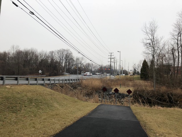
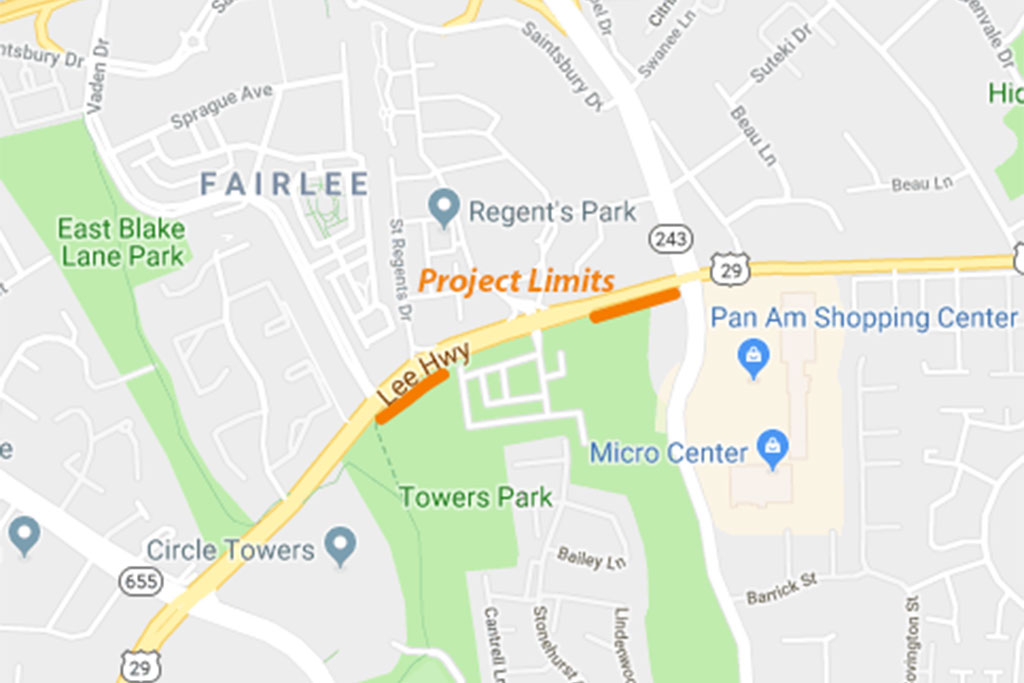
For years, the shared sidewalk on the south side of Lee Highway has ended abruptly with a ditch.
But a planned bike/pedestrian path on the highway just south of the Vienna Metro station could finally bridge that divide and make the sidewalks more walkable.
At a meeting tonight (Tuesday), Virginia Department of Transportation (VDOT) is scheduled to discuss plans to complete missing segments of a shared-use path on the southern side of Lee Highway between Vaden Drive and Nutley Street. The path aims to improve safety and accessibility for bicyclists and pedestrians near the Fairlee neighborhood.
The $1.3 million project is being funded through the Transform I-66 Outside the Beltway project.
Design approval for the project is scheduled for this fall, with construction beginning summer 2021.
The meeting is scheduled for 6:30 at Fairhill Elementary School (3001 Chichester Lane) with a presentation starting at 7 p.m.
")
Fairfax County officials are hoping a new lane restriping on Pimmit Hills streets can trick speeders into slowing down.
At a meeting at Westgate Elementary last night (Monday), Fairfax County Department of Transportation (FCDOT) staff said that Lisle Avenue — a main traffic route through Pimmit Hills — and Pimmit Drive are not wide enough to add bike lanes while maintaining street parking.
But staff said adding clear designators of the parking spots could give the street a “narrowing effect” that has been shown to reduce excessive speeding.
The actual size of the lanes doesn’t change, but the narrowing can have a psychological impact on drivers and reduce the feeling of wide-open roads that lulls drivers into the idea that it’s safe to speed.
“We see reductions in outlying speeds of 10-20 miles above the speed limit on traditionally wide roads,” said Chris Wells, bicycle and pedestrian program manager for FCDOT. “These narrower streets benefit in eliminating the fastest speeders.”
")
Normally, Wells said he would like to see bicycle lanes added, which would also have the narrowing effect, but that the only way to introduce bike lanes would have been to take away street parking.
The lane changes are being planned as part of the Virginia Department of Transportation’s planned repaving of the entire Pimmit Hills Neighborhood.
Allison Richter, liaison for Fairfax and Arlington counties for VDOT, said that Pimmit Hills had been on the schedule for a while, but water line work in the area meant VDOT held off because they didn’t want to put down asphalt only for it to be torn up again.
The timeline of when the repaving and restriping will take place is vague, occurring sometime between April and November. Richter said VDOT lets contractors select their own schedule as a cost-saving measure, but more exact dates will be known closer to when work starts.
At the meeting, a half dozen local residents also urged officials to look at the intersection of Pimmit Drive and Route 7, which they said is terrible for pedestrians and faces frequent backups into the Trader Joe’s parking lot. Wells said staff would look into what could be done to improve the location, but they’re restrained at the moment to the project’s scope.
Photo via Google Maps
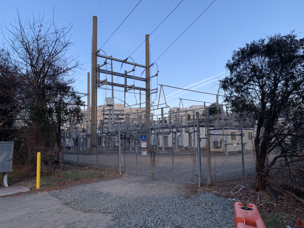
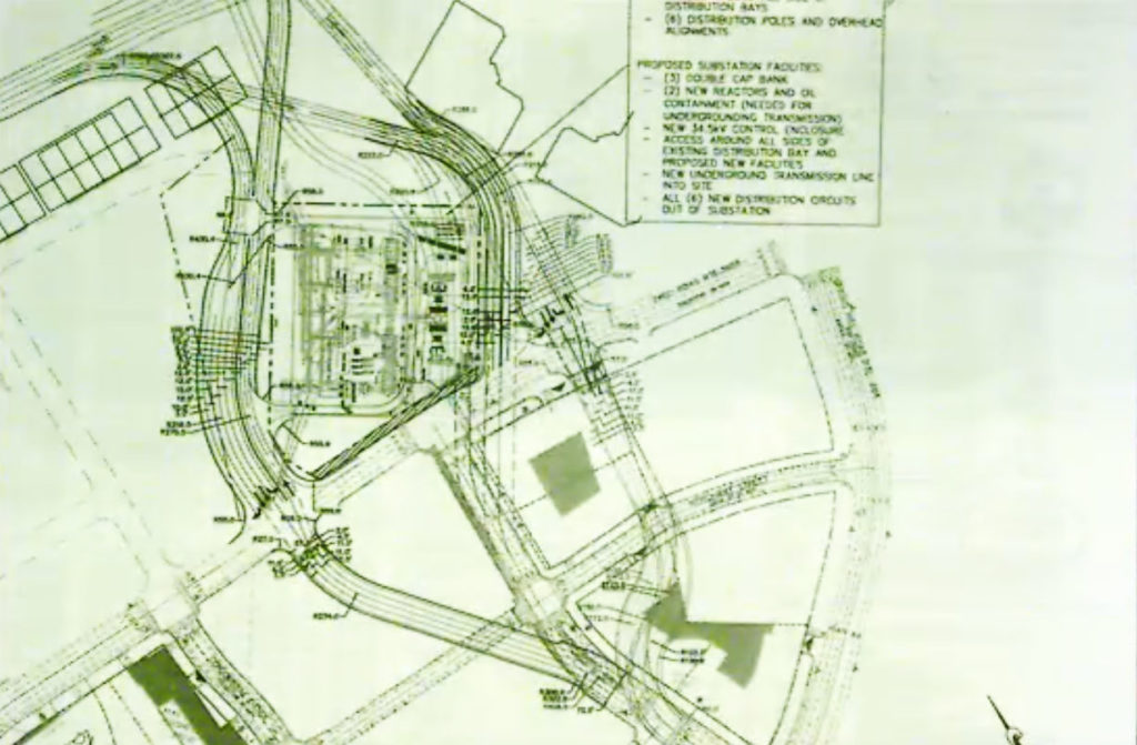
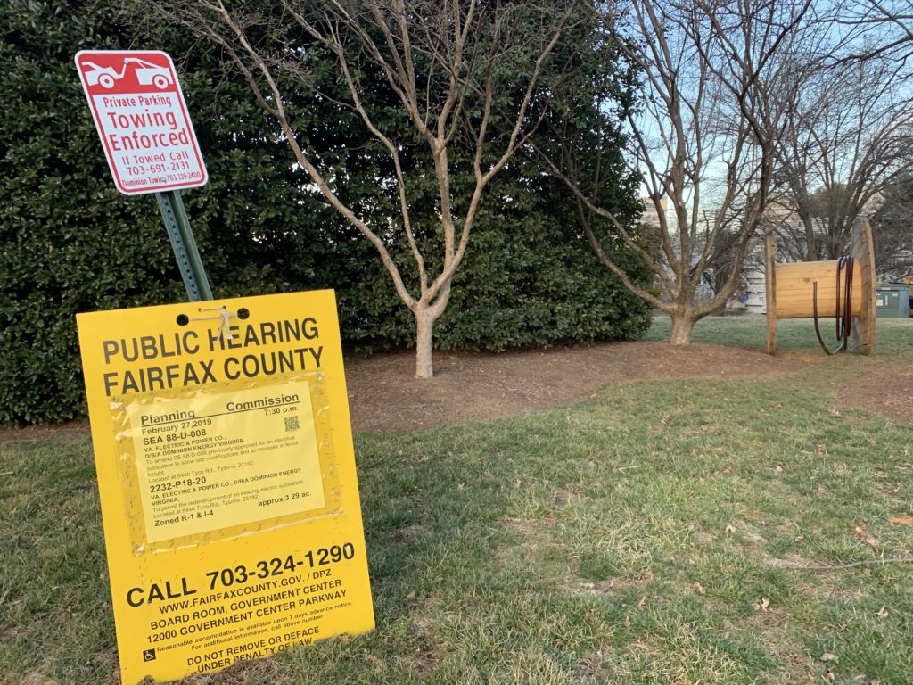
Dominion Energy is rebuilding its substation in Tysons, but will have to design the project around a long-planned ramp connecting downtown Tysons to the Dulles Toll Road.
At a Planning Commission meeting on Feb. 27, the Commission ultimately deferred a decision on the substation to March 13 to address technical details related to the site’s exterior. But while the substation itself is probably of little interest to most Tysonians, if they even spot it behind the dense tree-cover, the conversation at the meeting included plans on building around the station to construct a new connection from Tysons to the Dulles Toll Road.
The “Greensboro Drive Connection” is a proposed ramp that would bypass the substation and connect Tyco Road to the parallel Dulles Toll Road. The new route would include a direct extension to Greensboro Drive, ending west of The Rotunda and just north of The Boro development.
While the project is seen as less costly than other connectivity alternatives and would function as a fairly conventional exit/entrance ramp, county staff also noted that the ramp could potentially load large amounts of traffic onto Tyco Road and would not be bicycle or pedestrian friendly.
But Fairfax County Planning Commission members said the new road could help revitalize Tyco Road, currently a strip-mall type set of retail being outpaced by more Metro-adjacent developments to the west.
During the Planning Commission meeting, staff noted that the potential ramp could be located on either side of the station, though they would closely abut the station.
If the project does move forward, construction likely wouldn’t start until FY 2028.
According to Sheri Aiken, senior land use planner for McGuire Woods, LLC (which is representing Dominion) the existing substation has been in place since the early 1960s but requires an upgrade to handle increased demand from Tysons. Aiken said the rebuilt station will utilize GIS equipment and have an overall more efficient and less cluttered look. The chain link fence around the project is also planned to be replaced with a 12-foot wall.
“This station is critical to the future of Tysons and to the effort put forward by Dominion Energy to work with undergrounding of the line,” said Planning Commission member Phillip Niedzielski-Eichner, who represents the Providence district.

Downed Trees Block Roads — A High Wind Warning is in effect for Fairfax County for most of the day. A number of trees are reported to have fallen in parts of the area, blocking roads, including in McLean on Old Dominion Drive at Franklin Park Road and on Georgetown Pike near the Beltway. [Twitter, Twitter]
Police Department Mourns Fallen K-9 — “Fairfax County Police Chief Edwin C. Roessler, Jr. announced the unexpected death today, Feb. 22, of K-9 Doby, one of our K-9 officers.” [FCPD]
FCPS Gets More Than Half of Budget — “For the second year in a row, Fairfax County plans to grant all of the transfer funds requested by the county school board… FCPS accounts for 52.9 percent of the county’s general fund budget. Hill’s proposed county transfer to the public school system exceeds the $2.1 billion requested by the school board.” [Fairfax Times]
The Case for Suburb-to-Suburb Transit — “The Purple Line, which is expected to begin service in late 2022, will provide an important suburb-to-suburb link, and local officials should seriously consider constructing extensions to Tysons Corner and Largo.” [Greater Greater Washington]
More Childless Households in Falls Church — “While the 2.4 million population in the Northern Virginia region, overall, is characterized by a continuing growth in numbers of children, and households with children, this is not true for Falls Church… the number of households with children in the City has actually decreased by 5.3 percent in that same period.” [Falls Church News-Press]
Local Doc Goes on Medical Mission Trip — “On Jan. 26, 2019, a team from… Virginia Oral, Facial & Implant Surgery of McLean flew from Dulles Airport to Punta Cana, Dominican Republic” on a medical mission trip to treat “both children and adults of Dominican and Haitian background.” [McLean Connection]
New Look for Tysons Reporter — Tysons Reporter is debuting a new, cleaner look for our site today. What do you think? Let us know in the comments.