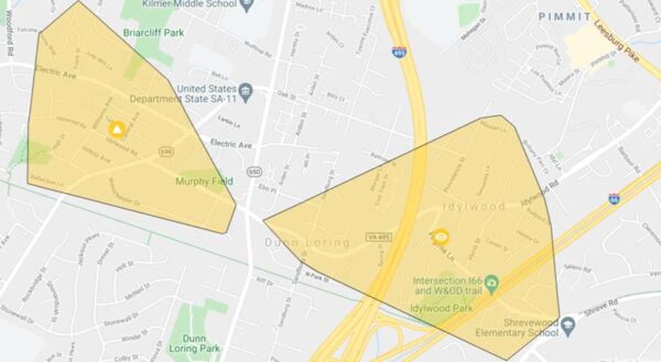
(Updated at 3 p.m.) Roughly 800 people in Dunn Loring are currently without power as rain continues to fall throughout the D.C. metropolitan area.
While flooding impacts appear to be more concentrated to the east in Arlington, Alexandria, and D.C. so far, Dominion Energy reports that 420 customers around Cedar Lane and Electric Avenue have lost power due to a broken pole.
There is also a power outage in Idylwood affecting 373 customers, though the cause of that outage is pending investigation.
The utility company estimates that power will be restored at both sites between 4 and 9 p.m.
The Fairfax County Police Department confirmed that the following roads have been closed:
- Old Courthouse Road at Besley is closed due to flooding
- Idylwood Road at Cedar is blocked due to down wires
- Georgetown Pike between Utterback and Springvale is closed due to a downed tree
As of 3 p.m., Lawyers Road at Hunter Mill Road in Vienna has also been closed due to high waters, according to Fairfax Alerts.
(Updated at 8:40 a.m.) Flood Watch in Effect — Fairfax County is under a Flood Watch into this afternoon, as “significant” rain is expected. Several roads have been closed due to flooding or downed trees, including Potomac River Road at Georgetown Pike, Lawyers Road at Hunter Mill, and Old Courthouse at Besley Road. [Fairfax County Fire and Rescue Department, FCPD]
Suspect in Tysons Sexual Assault Charged in New Incident — Fairfax County police have filed new sexual assault charges against a Woodbridge man who was arrested on Sept. 3 in connection with a sexual assault reported at a Tysons hotel in July. Reported on Aug. 26, the second incident involved the man allegedly assaulting a woman he’d arranged to meet at a hotel in the Seven Corners area. [Patch]
FCPS Shares SAT Results — The Class of 2021 performed above the national average on the SAT with just a 4.4% drop in participation, compared to a 31.4% global decline, despite the challenges of conducting standardized testing during the pandemic, Fairfax County Public Schools reported yesterday (Wednesday). Results from the College Board showed that Asian and white students recorded higher average scores than their Black and Hispanic counterparts. [WTOP]
Area Officials Consider Prioritizing Equity in Planning — The Metropolitan Washington Council of Governments board will vote on Oct. 13 on a regional transportation and land use plan that would prioritize low-income residents and communities of color when allocating funds for affordable housing, transportation, and other projects. Planners say the move would help address disparities in health outcomes and access to transit and other services. [The Washington Post]
Tysons Media Company Has Suitors — “Tegna Inc. (NYSE: TGNA), the Tysons-based operator of dozens of U.S. television stations, said Tuesday it has recently received multiple acquisition proposals — a new round of overtures after offers last year were pulled as the Covid-19 pandemic was taking hold. According to reports, media mogul Byron Allen is teaming with alternative investment firm Ares Management Corp. (NYSE: ARES) on a bid, while private equity giant Apollo Global Management Inc. (NYSE: APO) and Standard General LP are joining on another.” [Washington Business Journal]
Regional Park Authority Founders Celebrated — The Northern Virginia Regional Park Authority recently lauded the achievements of its founders, including conservationist Ira Gabrielson, who gave land to Fairfax County that became Oakton’s Gabrielson Gardens Park. Started 62 years ago, NOVA Parks has preserved more than 12,000 acres of land and oversees attractions like the Washington & Old Dominion Regional Trail. [Sun Gazette]

Updated at 3 p.m. — Swinks Mill Road in McLean has reopened after floodwaters swept debris onto the bridge at Scott Run this morning.
Updated at 12:10 p.m. — A Tornado Watch has been issued for the D.C. area, including Fairfax County, until 7 p.m.
Updated at 11:30 a.m. — All activities scheduled to take place in Fairfax County Public Schools this afternoon and evening have been canceled due to the anticipated inclement weather.
Earlier: Several feet of water surrounded a car on a road in Wolf Trap this morning (Wednesday) after an overnight storm passed through Fairfax County, producing flooding with more rain expected to fall throughout the day.
The National Weather Service issued a Flood Warning at 8:35 a.m. today (Wednesday) for central Fairfax County and Northern Virginia that will be in effect until noon.
“At 8:35 a.m. EDT, stream gauges report water levels continue to rise from earlier heavy rain,” the NWS said in the alert. “Flooding is already occurring in the warned area. Between 1.5 and 2.5 inches of rain have fallen.”
A Flash Flood Watch is also in effect for much of the D.C. area through 8 a.m. tomorrow (Thursday).
Fairfax County officials warned people not to drive through flooded routes. It was unclear the extent of rescue efforts that occurred in Wolf Trap, which the county first described as Vienna. A spokesperson later said officials responded to the 9900 block of Browns Mill Road.
Officials closed several roads due to flooding, including Old Courthouse and Besley roads in Tysons, Fairfax County Police Department reported.
Locations expected to face flooding include Dunn Loring, Great Falls, Merrifield, Pimmit Hills, Tysons, and Vienna.
Scenes from a county road this morning in Vienna.
PLEASE do not drive through flooded roads. There's more rain coming our way today from #Ida.
Turn around, don't drown. pic.twitter.com/Lx6IE840gI
— Fairfax County Government 🇺🇸 (@fairfaxcounty) September 1, 2021
The Virginia Department of Transportation’s Northern Virginia District reported at 8:55 a.m. that Swinks Mill Road has been closed just north of Scott Run, posting a photo on Twitter of damage to a bridge over the stream.
McLean: Swinks Mill Rd is closed just north of the bridge over Scott Run. The bridge itself is fine. Crews will be removing debris and repairing the approach to the bridge. This is not expected to be a long-term closure. pic.twitter.com/cCUuvQN3fO
— VDOT Northern VA (@VaDOTNOVA) September 1, 2021
The flooding and rain come courtesy of Tropical Depression Ida, the remnants of the hurricane that slammed the Gulf Coast earlier this week.
While the storm is expected to become post-tropical today, it could still bring three to eight inches of rain with some higher amounts through Thursday, and significant and life-threatening flash flooding is likely in the mid-Atlantic, the NWS Weather Prediction Center said in a 5 a.m. bulletin.
“We are expecting several inches of rain today from the remnants of Hurricane Ida, picking up in intensity in the early afternoon until around midnight,” Fairfax County said in a post on its emergency information blog. “We have already experienced an early morning storm that has led to power outages, swift water rescues and numerous road closures due to downed trees and flooded roads.”
The Fairfax County Fire and Rescue Department is urging people to avoid driving through flooded or closed roadways, noting that stalled and trapped cars put the driver, passengers, and first responders in unnecessary danger.
“By now, many drivers across Fairfax County know which roads traditionally flood,” the department wrote in a blog post. “FCFRD asks that if you need to be on the roadways today that you stay informed and plan alternate routes around flooded roadways. Our firefighters and paramedics do not want to meet you by (a preventable) ‘accident’!”
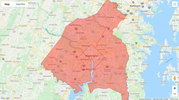
A Flash Flood Watch has been issued for the D.C. area, including Fairfax County.
The alert will take effect at 1 p.m. and is currently set to expire at 11 p.m., as the National Weather Service says “numerous showers and thunderstorms” are expected to pass through the region this afternoon and evening.
While just up to an inch of rain is projected to fall on average, the thunderstorms could bring heavy rainfall within a short period of time to localized areas, potentially leading streams and creeks to flood.
Here is the full NWS alert:
…FLASH FLOOD WATCH IN EFFECT FROM 1 PM EDT THIS AFTERNOON THROUGH
THIS EVENING…The National Weather Service in Sterling Virginia has issued a
* Flash Flood Watch for portions of DC, central Maryland and northern Virginia, including the following areas: in DC, District of Columbia. In central Maryland, Central and Southeast Howard, Central and Southeast Montgomery and Prince Georges. In northern Virginia, Arlington/Falls Church/Alexandria and Fairfax.
* From 1 PM EDT this afternoon through this evening.
* Numerous showers and thunderstorms are expected this afternoon and evening. Average rainfall amounts are expected to be between one half to one inch. However, thunderstorms will be capable of
producing very heavy rainfall rates of 2 to 3 inches per hour, causing localized amounts of 2 to 4 inches possible. While storms are possible any time this afternoon through this evening, the most widespread thunderstorm activity is most likely to be late this afternoon through early this evening.* Heavy rainfall amounts in a short period of time may result in rapid rises on streams and creeks as well as the potential for flash flooding in urban areas.
PRECAUTIONARY/PREPAREDNESS ACTIONS…
You should monitor later forecasts and be prepared to take action should Flash Flood Warnings be issued.
Today’s anticipated showers come after a relatively brief thunderstorm took out power for thousands of people in McLean.
The issues appear to have been largely addressed overnight, but Dominion Energy’s outage map shows a handful of customers still waiting for electricity to be restored, including 24 people east of Dolley Madison Estates Park. A crew is assessing the damage, and the estimated time of restoration is 11 a.m. to 4 p.m.
[8/27 at 8:41 AM] A Flash Flood Watch is in effect today from 1 PM to 11 PM. Numerous showers & t'storms are expected during this time. Heavy rainfall amounts in a short period of time may result in rapid rises on streams & creeks as well as cause flash flooding on roads. #VaWx pic.twitter.com/BYIlGyn8ft
— Ready Fairfax (@ReadyFairfax) August 27, 2021
More Rain Soaks Northern Virginia — Up to five inches of rain fell across the region early Sunday morning (Aug. 15), causing flash flooding in Arlington, Alexandria, Fairfax and Prince William counties. High water closed Arlington Boulevard near Route 7 in Falls Church, while downed wires shut down Clarks Crossing Road at Elgin Drive in Vienna and Melbourne Drive at Van Fleet Drive in McLean. [Inside NoVA]
New Scotts Run Fire Station Begins Operations — The Fairfax County Fire and Rescue Department’s new Station 44 at Scotts Run officially went into service on Saturday (Aug. 14). Located at 1766 Old Meadow Lane, the station had been under construction since 2019 and contains three vehicle bays, offices, and living quarters for up to 12 people per shift. A grand opening is scheduled for Sept. 18. [Chief John Butler/Twitter]
Construction Starts on Bridge Over I-495 — Work is now underway on the bicycle and pedestrian bridge over I-495 near Route 123 and a shared-use path that, when extended along Old Meadow Road, will connect Tysons Corner Center to the McLean Metro station. Traffic impacts, including lane closures, will occur on the Capital Beltway and Old Meadow during construction, which is expected to finish in summer 2022. [VDOT]
Woman Assaulted Near Tysons Corner Center — A man yelled derogatory statements at two women who were sitting on a bench in the 7900 block of Tysons One Place at 9:55 p.m. on Aug. 10 and assaulted one of them before fleeing the area. The Fairfax County Police Department has labeled the incident a bias or hate crime. [FCPD]
Updated at 3:50 p.m. — A Flash Flood Warning has been issued for Fairfax County until 6:30 p.m.
Updated at 2:45 p.m. — The Severe Thunderstorm Warning has been extended to 3:30 p.m., and the list of affected locations now includes Vienna and Falls Church.
Earlier: A Severe Thunderstorm Watch has been issued for Fairfax County and the rest of the D.C. area, joining a Flash Flood Watch that will take effect at 2 p.m. today (Thursday).
The thunderstorm watch took effect at 12:40 p.m. and will remain in place until 8 p.m., according to the National Weather Service.
A Severe Thunderstorm Warning has also been issued for the northeastern part of the county, including Wolf Trap and McLean around the American Legion Bridge. That will be in effect until 1:45 p.m.
The Severe Thunderstorm Warning from the NWS says:
* At 103 PM EDT, a severe thunderstorm was located over Ashburn, or near Broadlands, moving east at 25 mph.
HAZARD…60 mph wind gusts and quarter size hail.
SOURCE…Radar indicated.
IMPACT…Damaging winds will cause some trees and large branches to fall. This could injure those outdoors, as well as damage homes and vehicles. Roadways may become blocked by downed trees. Localized power outages are possible. Unsecured light objects may become projectiles.
* Locations impacted include…
Rockville, Bethesda, Gaithersburg, Reston, Olney, Herndon, Broadlands, Lansdowne, Lowes Island, Brambleton, American Legion Bridge, Aspen Hill, Potomac, North Bethesda, Ashburn, Sterling, North Potomac, Redland, Wolf Trap and Great Falls.
“For your protection move to an interior room on the lowest floor of a building,” the NWS advises.
[7/1 at 1:10 PM] A Severe Thunderstorm Warning has been issued until 1:45 PM. Seek shelter if you are outside.📍Impacted locations include: Reston, Herndon, Wolf Trap, and Great Falls. #VaWx https://t.co/IRoso825rm
— Ready Fairfax (@ReadyFairfax) July 1, 2021
A Severe Thunderstorm Watch has been issued for parts of DE, DC, MD, NJ, PA, VA until 8 PM EDT. #MDwx #VAwx #DCwx pic.twitter.com/2sf7WdTrtE
— NWS Baltimore-Washington (@NWS_BaltWash) July 1, 2021
The rain just keeps coming.
While a Flash Flood Warning issued yesterday (Thursday) for the D.C. region, including Fairfax County, was canceled ahead of schedule at 7:15 p.m., the National Weather Service has extended the Flash Flood Watch that was set to end at midnight through today (Friday).
Issued at 3:03 a.m., the new alert will be in effect through this evening, as showers and thunderstorms are expected to bring two to four additional inches of rain to the area.
Here is the full alert:
…FLASH FLOOD WATCH IN EFFECT THROUGH THIS EVENING…
The National Weather Service in Sterling Virginia has expanded the
* Flash Flood Watch to include portions of Virginia and West Virginia, including the following areas: in Virginia, Clarke, Eastern Loudoun, Fairfax, Frederick VA, Page, Shenandoah, Warren and Western Loudoun. In West Virginia, Berkeley, Eastern Grant, Eastern Mineral, Eastern Pendleton, Hampshire, Hardy, Jefferson, Western Grant, Western Mineral and Western Pendleton.
* Through this evening
* Additional showers and thunderstorms capable of producing heavy rainfall amounts of 2 to 4 additional inches are expected to re-develop early this morning and persist into this afternoon.
* More heavy rainfall may cause additional flash flooding.
“A Flash Flood Watch means that conditions may develop that lead to Flash Flooding,” the NWS says. “Flash Flooding is a very dangerous situation. You should monitor later forecasts and be prepared to take action should Flash Flood Warnings be issued.”
The threat for flash flooding persists in the Mid Atlantic again today.
Each year, more deaths occur due to flooding than from any other thunderstorm related hazard – and half of those are the result of a vehicle being driven into floodwaters. #TurnAroundDontDrown https://t.co/ffxF3YDP4y
— National Weather Service (@NWS) June 11, 2021
Updated at 4:35 p.m. — Vienna and Falls Church have now been added to the Severe Thunderstorm Warning, which has been extended to 5:15 p.m. today.
Earlier: Fairfax County and other areas in Northern Virginia have been put under a Severe Thunderstorm Warning on top of a Severe Thunderstorm Watch that will be in effect until 10 p.m.
Here is the full alert from the National Weather Service, which is scheduled to last until 4:45 p.m.:
At 405 PM EDT, a severe thunderstorm was located near Warrenton, moving northeast at 30 mph.
HAZARD…60 mph wind gusts.
SOURCE…Radar indicated.
IMPACT…Damaging winds will cause some trees and large branches to fall. This could injure those outdoors, as well as damage homes and vehicles. Roadways may become blocked by downed trees. Localized power outages are possible. Unsecured light objects may become projectiles.
* Locations impacted include…
Centreville, Reston, Annandale, South Riding, Herndon, Fairfax, Mantua, Dulles International Airport, Burke, Linton Hall, Oakton, Sterling, Chantilly, Merrifield, Bull Run, Haymarket, Arcola, Manassas, Sudley and Manassas Park.PRECAUTIONARY/PREPAREDNESS ACTIONS…
For your protection move to an interior room on the lowest floor of a building.
Updated at 4:10 p.m. — The National Weather Service has now upgraded Fairfax County to a Severe Thunderstorm Warning, advising people to move to an interior room on the lowest floor of a building.
In effect until 4:45 p.m., the warning was issued at 4:01 p.m. after a severe thunderstorm was spotted near Middleburg. The storm was reportedly moving east at 30 miles per hour.
Here is the full alert:
The National Weather Service in Sterling Virginia has issued a Severe Thunderstorm Warning for…
Southeastern Loudoun County in northern Virginia…
Northwestern Fairfax County in northern Virginia…
Northeastern Fauquier County in northern Virginia…
Northwestern Prince William County in northern Virginia…* Until 445 PM EDT.
* At 400 PM EDT, a severe thunderstorm was located near Middleburg, or 8 miles west of Brambleton, moving east at 30 mph.
HAZARD…60 mph wind gusts.
SOURCE…Radar indicated.
IMPACT…Damaging winds will cause some trees and large branches to fall. This could injure those outdoors, as well as damage homes and vehicles. Roadways may become blocked by downed trees. Localized power outages are possible. Unsecured light objects may become projectiles.
* Locations impacted include…
Reston, South Riding, Herndon, Vienna, Broadlands, Lowes Island, Brambleton, Dulles International Airport, Ashburn, Oakton, Sterling, Chantilly, Wolf Trap, Great Falls, Countryside, Middleburg, Arcola, Belmont, Aldie and Sterling Park.
Earlier: Fairfax County is currently under a Severe Thunderstorm Watch, with scattered showers anticipated throughout the D.C. area this afternoon.
The alert will be in effect until 8 p.m. The National Weather Service says that a thunderstorm could potentially hit after 5 p.m.
“Some storms could be severe, with large hail and damaging winds,” the NWS forecast for Tysons says.
With a 60% chance of precipitation, between a tenth and a quarter of an inch of rain could fall this afternoon, and another quarter to half inch could come in the evening.
[5/4/21 at 2:35 PM]
⚠️Fairfax County is currently under a Severe Thunderstorm Watch ⛈️ until 8 PM
🚨Know your alerts: Watch (be prepared) vs. Warning (take action)
🏫Identify your safe place: inside, interior, no windows#VaWx #ReadyFairfax #BePrepared pic.twitter.com/ADS53eMd5E— Ready Fairfax (@ReadyFairfax) May 4, 2021
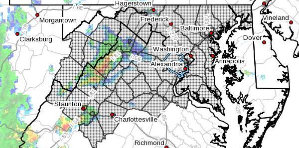
Map via National Weather Service
Updated 9:50 a.m. — Aas a Flood Warning is in effect for the area until 3:30 p.m. today. NWS said that Vienna, Falls Church, Tysons and Merrifield may experience flooding.
Earlier: People can expect more thunderstorms and possibly heavy rain.
The National Weather Service issued a Flash Flood Watch for today (Thursday).
More from NWS:
Slow moving thunderstorms capable of producing heavy rainfall may develop today. Heavy rainfall from thunderstorms may lead to flash flooding.
Potential impacts include rapid rises of water, flooded roads and flooding of structures in low lying areas near streams. Landslides and washouts are also possible.
People are advised to not drive through water they don’t know the depth.
Another flash flood watch is in effect for today. Multiple rounds of thunderstorms with heavy rain will be possible. pic.twitter.com/w40WR0SEvU
— NWS Baltimore-Washington (@NWS_BaltWash) August 13, 2020
Flash Flood Watch In Effect until midnight tonight (8/13)! If you must be on roads, never drive through a flooded roadway! PLEASE #TurnAroundDontDrown! Plan alternate routes around flooded roads. Don't put you, any passengers AND #FCFRD firefighters/paramedics in harm’s way! pic.twitter.com/xhoUAocquH
— Fairfax County Fire/Rescue (@ffxfirerescue) August 13, 2020


