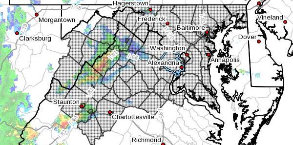
Updated at 4:10 p.m. — The National Weather Service has now upgraded Fairfax County to a Severe Thunderstorm Warning, advising people to move to an interior room on the lowest floor of a building.
In effect until 4:45 p.m., the warning was issued at 4:01 p.m. after a severe thunderstorm was spotted near Middleburg. The storm was reportedly moving east at 30 miles per hour.
Here is the full alert:
The National Weather Service in Sterling Virginia has issued a Severe Thunderstorm Warning for…
Southeastern Loudoun County in northern Virginia…
Northwestern Fairfax County in northern Virginia…
Northeastern Fauquier County in northern Virginia…
Northwestern Prince William County in northern Virginia…* Until 445 PM EDT.
* At 400 PM EDT, a severe thunderstorm was located near Middleburg, or 8 miles west of Brambleton, moving east at 30 mph.
HAZARD…60 mph wind gusts.
SOURCE…Radar indicated.
IMPACT…Damaging winds will cause some trees and large branches to fall. This could injure those outdoors, as well as damage homes and vehicles. Roadways may become blocked by downed trees. Localized power outages are possible. Unsecured light objects may become projectiles.
* Locations impacted include…
Reston, South Riding, Herndon, Vienna, Broadlands, Lowes Island, Brambleton, Dulles International Airport, Ashburn, Oakton, Sterling, Chantilly, Wolf Trap, Great Falls, Countryside, Middleburg, Arcola, Belmont, Aldie and Sterling Park.
Earlier: Fairfax County is currently under a Severe Thunderstorm Watch, with scattered showers anticipated throughout the D.C. area this afternoon.
The alert will be in effect until 8 p.m. The National Weather Service says that a thunderstorm could potentially hit after 5 p.m.
“Some storms could be severe, with large hail and damaging winds,” the NWS forecast for Tysons says.
With a 60% chance of precipitation, between a tenth and a quarter of an inch of rain could fall this afternoon, and another quarter to half inch could come in the evening.
[5/4/21 at 2:35 PM]
⚠️Fairfax County is currently under a Severe Thunderstorm Watch ⛈️ until 8 PM
🚨Know your alerts: Watch (be prepared) vs. Warning (take action)
🏫Identify your safe place: inside, interior, no windows#VaWx #ReadyFairfax #BePrepared pic.twitter.com/ADS53eMd5E— Ready Fairfax (@ReadyFairfax) May 4, 2021
Map via National Weather Service


