")
Updated at 3 p.m. — Swinks Mill Road in McLean has reopened after floodwaters swept debris onto the bridge at Scott Run this morning.
Updated at 12:10 p.m. — A Tornado Watch has been issued for the D.C. area, including Fairfax County, until 7 p.m.
Updated at 11:30 a.m. — All activities scheduled to take place in Fairfax County Public Schools this afternoon and evening have been canceled due to the anticipated inclement weather.
Earlier: Several feet of water surrounded a car on a road in Wolf Trap this morning (Wednesday) after an overnight storm passed through Fairfax County, producing flooding with more rain expected to fall throughout the day.
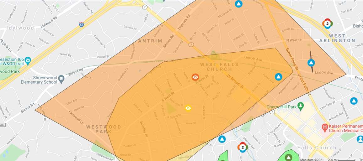
The National Weather Service issued a Flood Warning at 8:35 a.m. today (Wednesday) for central Fairfax County and Northern Virginia that will be in effect until noon.
“At 8:35 a.m. EDT, stream gauges report water levels continue to rise from earlier heavy rain,” the NWS said in the alert. “Flooding is already occurring in the warned area. Between 1.5 and 2.5 inches of rain have fallen.”
A Flash Flood Watch is also in effect for much of the D.C. area through 8 a.m. tomorrow (Thursday).
Fairfax County officials warned people not to drive through flooded routes. It was unclear the extent of rescue efforts that occurred in Wolf Trap, which the county first described as Vienna. A spokesperson later said officials responded to the 9900 block of Browns Mill Road.
Officials closed several roads due to flooding, including Old Courthouse and Besley roads in Tysons, Fairfax County Police Department reported.
Locations expected to face flooding include Dunn Loring, Great Falls, Merrifield, Pimmit Hills, Tysons, and Vienna.
Scenes from a county road this morning in Vienna.
PLEASE do not drive through flooded roads. There's more rain coming our way today from #Ida.
Turn around, don't drown. pic.twitter.com/Lx6IE840gI
— Fairfax County Government 🇺🇸 (@fairfaxcounty) September 1, 2021
The Virginia Department of Transportation’s Northern Virginia District reported at 8:55 a.m. that Swinks Mill Road has been closed just north of Scott Run, posting a photo on Twitter of damage to a bridge over the stream.
McLean: Swinks Mill Rd is closed just north of the bridge over Scott Run. The bridge itself is fine. Crews will be removing debris and repairing the approach to the bridge. This is not expected to be a long-term closure. pic.twitter.com/cCUuvQN3fO
— VDOT Northern VA (@VaDOTNOVA) September 1, 2021
The flooding and rain come courtesy of Tropical Depression Ida, the remnants of the hurricane that slammed the Gulf Coast earlier this week.
While the storm is expected to become post-tropical today, it could still bring three to eight inches of rain with some higher amounts through Thursday, and significant and life-threatening flash flooding is likely in the mid-Atlantic, the NWS Weather Prediction Center said in a 5 a.m. bulletin.
“We are expecting several inches of rain today from the remnants of Hurricane Ida, picking up in intensity in the early afternoon until around midnight,” Fairfax County said in a post on its emergency information blog. “We have already experienced an early morning storm that has led to power outages, swift water rescues and numerous road closures due to downed trees and flooded roads.”
The Fairfax County Fire and Rescue Department is urging people to avoid driving through flooded or closed roadways, noting that stalled and trapped cars put the driver, passengers, and first responders in unnecessary danger.
“By now, many drivers across Fairfax County know which roads traditionally flood,” the department wrote in a blog post. “FCFRD asks that if you need to be on the roadways today that you stay informed and plan alternate routes around flooded roadways. Our firefighters and paramedics do not want to meet you by (a preventable) ‘accident’!”
")
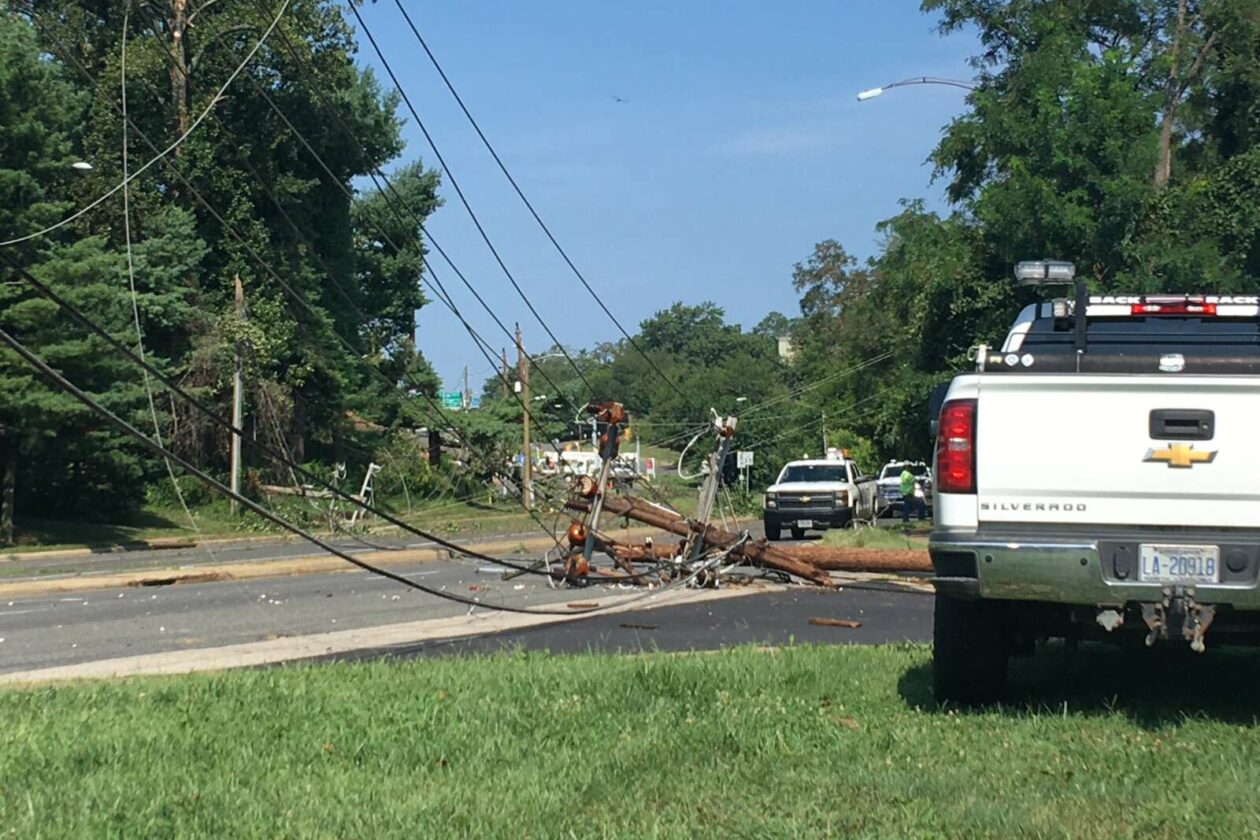
(Updated at 4:45 p.m.) A thunderstorm that has reportedly dropped hail in nearby Arlington County and D.C. has also knocked out power for more than 3,000 McLean residents.
A Severe Thunderstorm Warning was issued for northeastern Fairfax County, though it was scheduled to end at 4:45 p.m.
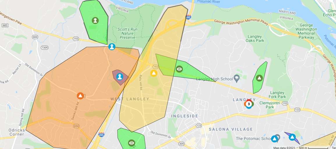
According to Dominion Energy’s outage map, power outages attributed to failed circuits were affecting 1,638 customers around Ingleside and Langley as well as 839 customers in the area around the Route 123 and George Washington Memorial Parkway interchange.
Another 703 customers in downtown McLean are also without power, though a cause is still under investigation.
Crews are awaiting assignment, and an estimated time of restoration for the power outages is pending investigation, according to Dominion.
In addition, traffic delays may be coming after a downed tree was reported on the southbound GW Parkway after Route 123.
[8/26 at 4:13 PM] A Severe Thunderstorm Warning has been issued until 4:45 PM for Northeastern Fairfax County. Significant lightning is associated with these storms. Please move indoors immediately. #VaWx pic.twitter.com/8EmcwGPhyE
— Ready Fairfax (@ReadyFairfax) August 26, 2021
")
I-66 West Lane Closures Start Tonight — I-66 West in the Vienna area will be reduced to a single travel lane around 10 p.m. today (Friday) and tomorrow with one lane remaining closed during the day on Saturday. The closures are needed to shift the westbound travel lanes between Gallows Road and Nutley Street to new pavement as part of the Transform 66 Outside the Beltway project. [VDOT]
Two Injured in McLean House Fire During Storm — Two people went to the hospital for non-life-threatening injuries after a house in the 6600 block of Osborn Street caught fire around 9:10 p.m. on Tuesday (Aug. 10). The fire, which displaced five occupants and resulted in approximately $25,000 in damages, was caused by an unattended candle placed too close to curtains during a thunderstorm-induced power outage. [FCFRD]
Craft Beer Restaurant Planned for Tysons Galleria — “Yard House, the casual, craft beer-focused restaurant with a growing Greater Washington presence, will open a new location inside the redeveloped former Macy’s store at the Tysons Galleria. Building permits filed this week with Fairfax County describe the project as eventually spanning 14,236 square feet and entailing an outdoor patio at the redone Galleria space.” [Washington Business Journal]
Falls Church Adds Affordable Housing — Falls Church City bought properties at 310 and 312 Shirley Street for $925,000 each on Wednesday (Aug. 11). The 2,560 square-foot buildings consist of four one-bedroom apartments that will be preserved as market-rate affordable units, joining the 16 such units that the City already owns at 208 Gibson Street and 302 Shirley Street. [City of Falls Church]
")
Updated at 4:25 p.m. — A Severe Thunderstorm Warning has now been issued for Fairfax County. In effect until 5 p.m., storms are moving east at 15 miles per hour with 60 mile-per-hour wind gusts that could bring down trees and large branches, potentially leading to power outages.
Earlier: Fairfax County is still in the process of recovering from last night’s storm, and the next one is already on the way.
The National Weather Service has put the entire D.C. region under a Severe Thunderstorm Watch until 9 p.m., warning of the potential for hail and damaging winds similar to the blasts that disrupted travel and power in the Vienna and Falls Church area yesterday (Tuesday).
A Severe Thunderstorm Watch has been issued until 9 PM this evening for all areas east of the Allegheny Front. Damaging winds and large hail will be the primary threat for these storms. pic.twitter.com/CXqq3C1nP4
— NWS Baltimore-Washington (@NWS_BaltWash) August 11, 2021
[8/11 at 2:15 PM] ⚠️A Severe Thunderstorm Watch is in effect until 9 PM tonight. Potential hazards from these storms include: damaging wind gusts, hail, lightning, and isolated flash flooding. Be prepared to move indoors and know what to do if a warning is issued. #VaWx #BeReady pic.twitter.com/4nGV078aXl
— Ready Fairfax (@ReadyFairfax) August 11, 2021
In addition, a Heat Advisory will remain in effect until 8 p.m. today with an Excessive Heat Watch scheduled to begin at noon tomorrow (Thursday), when the heat index could reach up to 105 degrees Fahrenheit.
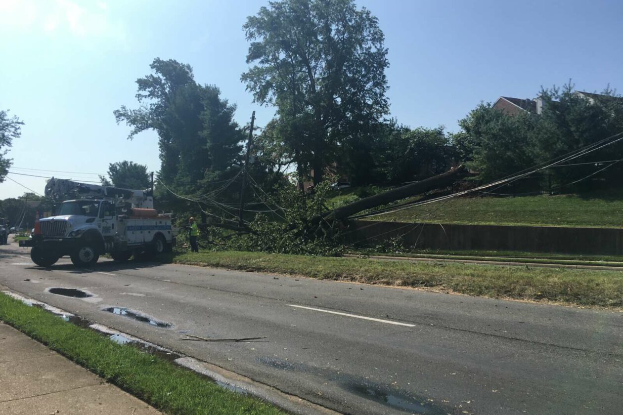
(Updated at 4:45 p.m.) Over 8,000 people in Fairfax County still don’t have electricity this evening (Wednesday) as crews work to restore power and clear downed trees, the aftermath of last night’s thunderstorm.
Commuters were experiencing delays as part of Leesburg Pike that’s requiring detours. Emergency responders shut down the roadway between George C. Marshall and Dominion drives in Falls Church due to downed trees and power lines there.
Police told Tysons Reporter around 4:30 p.m. that the road remains closed in both directions and that power crews are attempting to clear the roadway and restore power, which could be completed in 10-12 hours.
“Follow detour signs in the area and please drive with caution,” Fairfax County Police Department said on Twitter.
Leesburg Pike remains shut down between George C Marshall Dr and Dominion Dr in Falls Church due to downed trees and power lines in the roadway. Follow detour signs in the area and please drive with caution #FCPD pic.twitter.com/FAFAYoEDRh
— Fairfax County Police (@FairfaxCountyPD) August 11, 2021
The Tysons-Pimmit Regional Library was closed due to the ongoing power outage resulting from fallen trees and downed power lines on Route 7, which remains closed for about a quarter-mile from the I-495 interchange.
A Fairfax County Public Library spokesperson confirmed the Tysons-Pimmit closure to Tysons Reporter and added that the Kingstowne and Sherwood Regional branches were also shut down at 11 a.m. due to a lack of power.
Leesburg Pike inside just I-495 is closed for about a 1/4 mile. Huge tree took down 4 poles & 2 spans of wires lay across Route 7.
Dozens of line workers are here ready to make repairs as soon as power is grounded. #SafetyFirst ETR is midnight. @VaDOTNOVA @DominionEnergy pic.twitter.com/TJwucK0PBO
— Peggy Fox (@PeggyDomEnergy) August 11, 2021
Metrobus warned of possible delays as it rerouted buses going in both directions on Route 28A due to the scene.
Metro’s Orange Line has also been experiencing numerous delays late last night and into this morning.
While power was restored to the West Falls Church station around 9:45 p.m. yesterday after a storm-related outage, service was suspended again an hour later between Vienna and East Falls Church in response to “an unauthorized person” on the train tracks at West Falls Church.
Lingering power issues outside Dunn Loring then contributed to delays as far as New Carrollton in Maryland; starting around 5 a.m., Metrorail reported that normal service on the Orange Line had resumed about an hour later, but by 7 a.m., a disabled train at Dunn Loring triggered more delays, this time in Vienna.
Metrorail said at 7:45 a.m. to expect delays in both directions on the Orange Line due to the “train malfunction” at Dunn Loring.
While electricity has been restored for many of the 50,000-plus Fairfax County residents who lost power last night, thousands of Dominion Energy customers are still without power, primarily in the Merrifield and Falls Church area.
Many businesses in the Pimmit and Falls Church areas put up signs indicating that they are closed due to the power outages, including the Whole Foods, Capital One Bank, Orangetheory Fitness, and My Eye Doctor in Idylwood Plaza.
At Tysons Station plaza, store after store posted closed signs. The sign for Java Loco Coffee said it expected to be closed for the day. Trader Joe’s used two freezer trucks in the rear of the plaza to store meats and food beginning last night when the store’s power went out, an employee said. Also in the rear of the plaza, Tyson’s Barber regained power around 11 a.m., a worker said Wednesday with a sigh of relief.
Behind Tysons Station plaza, a detached Seven-11 was closed, but a Sunoco gas station had its pumps working as well as electricity. Across from Tysons Station, an Exxon had no pumps working, and an employee operated the store in the dark for cash-paying customers and regulars.
According to the utility company’s outage map, Dominion expects power to be restored between 7 p.m. today and midnight, mirroring similar restoration estimates for nearby areas.
Can @capitalweather tell us what raced through Falls Church around 5:30 today? Wow, what a powerful burst of wind and rain! And @DominionEnergy we hope you’ll be here soon. pic.twitter.com/rS4s1QUt7M
— Peter Kiley (@PDad) August 11, 2021
Meanwhile, a heat advisory will be in effect today from noon until 8 p.m., and an excessive heat watch, where dangerously hot conditions are possible, will be in effect for tomorrow (Thursday) afternoon and evening.
The Fairfax County Fire and Rescue Department is reminding people to use air conditioning, avoid direct sunlight, choose appropriate clothing, hydrate, and follow other safety tips.
The Falls Church Community Center has been turned into a cooling center until 8 p.m., the City of Falls Church announced this morning. Face coverings and social distancing are required for all, and visitors must sign a COVID-19 waiver.
The city also shared information about how to handle fallen trees and suggested reporting downed power lines to the police department at 703-241-5053.
“Community members should play it safe in the aftermath of last night’s storm that left many without power today as well as downed trees and branches,” the city said in its news release.
Falls Church City residents may see a delay in trash and recycling collections today. Bins that are not collected by 4 p.m. can be reported to the city’s Solid Waste Hotline 703-248-5160, option 1.
Severe thunderstorms and flash floods are possible during afternoon and evening hours from today through Saturday.

Updated at 9:45 p.m. — Metro has restored service on the Orange Line between Vienna and East Falls Church after it was suspended earlier due to a power outage at the West Falls Church Metro station.
Earlier: A thunderstorm has taken out power for thousands in the Tysons area, particularly around Vienna, Falls Church, and Merrifield.
The National Weather Service issued a Severe Thunderstorm Warning for northeastern Fairfax County at 5:12 p.m., though by that time, the rumble of thunder had likely alerted anyone in the area.
Moving east at 15 miles per hour, the storm brought 60 mile-per-hour wind gusts, according to the NWS, which warned about the potential for fallen trees and large branches.
“This could injure those outdoors, as well as damage homes and vehicles,” the alert said. “Roadways may become blocked by downed trees. Localized power outages are possible. Unsecured light objects may become projectiles.”
The storm arrived quickly, leaving many unprepared.
Prob should have put the umbrellas down in Tysons. This poor guy. @nbcwashington pic.twitter.com/9SZTfvOlrd
— Adam Tuss (@AdamTuss) August 10, 2021
At least 51,423 Dominion Energy customers in Fairfax County are now without power, according to the site PowerOutage.US.
Dominion Energy’s outage map shows many of the outages concentrated in Falls Church, Merrifield, and Vienna, where businesses in the commercial area along Maple Avenue and Church Street were among those that lost electricity.
")
Dominion Energy generally estimates that power will be restored between 7 p.m. and midnight, though the cause of some outages is still under investigation. Most of the outages have been attributed to out circuits, but one affecting more than 5,000 people around Vienna and Oakton is the result of a tree falling on a power line.
Metro has suspended service on the Orange Line between Vienna and East Falls Church due to a loss of power at the West Falls Church station. The transit agency says shuttle buses have been requested.
Orange Line Delay: Train service suspended between Vienna & E Falls Church due to a power outage at W Falls Church. Shuttle buses requested.
— Metrorail Info (@Metrorailinfo) August 10, 2021
Power out in Dunn Loring too pic.twitter.com/xwAP95RWMY
— James Holcombe (@jameslholcombe) August 10, 2021
Even with the thunderstorm, Fairfax County can expect little relief from the summer heat and humidity over the next couple of days, with the heat index expected to surpass 100 degrees tomorrow and on Thursday (Aug. 12).
")
Like much of the D.C. area, Fairfax County is now under a Severe Thunderstorm Watch that will be in place until 9 p.m.
The region is bracing for a second consecutive night of potentially damaging wind and rainfall after a storm that swept through late Wednesday (July 28) resulted in power outages that affected thousands of people in Fairfax County, particularly around McLean and Falls Church.
While many of the outages have been addressed, Dominion Energy’s outage map shows that, as of 3:30 p.m., crews are still working to restore electricity in some areas. The current estimated time of restoration for the lingering outages ranges from before 5 p.m. to 6-11 p.m.
A Tornado Watch has been issued for D.C.’s Maryland suburbs, but Fairfax County could see damaging hail, isolated flash flooding, and large hail from the incoming storm, according to the National Weather Service.
The Fairfax County Office of Emergency Management advises residents to “stay weather aware and know what to do if a warning is issued,” which would mean that severe weather is imminent or underway.
A Severe Thunderstorm Watch has been issued for areas outside of the Tornado Watch, both of which are until 9 PM tonight. Main threat for these storms will be for damaging winds, large hail, isolated flash flooding and tornadoes. pic.twitter.com/eNM7nyBtFK
— NWS Baltimore-Washington (@NWS_BaltWash) July 29, 2021
Almost 7,000 people in Fairfax County still have no electricity after a thunderstorm took out trees and wires late last night (Wednesday).
According to PowerOutage.US, 6,920 Dominion Energy customers in the county are experiencing a power outage as of 9:10 a.m. Dominion’s outage map shows that, while there are scattered outages farther south, the vast majority of those without power are in McLean and Falls Church.
Crews are working on and investigating many of the reported outages. The estimated time of restoration is noon to 5 p.m. for those in the Langley and Scott’s Run area and 6-11 p.m. for the many outages in McLean southeast of Route 123 and West Falls Church.
“Our plan includes all resources engaged w/ over 50 bucket trucks,” Dominion spokesperson Peggy Fox said on Twitter. “Stay away from downed lines — assume energized.”
Good morning.
NoVa @DominionEnergy
Storm Damage Power Outage Update:
9009 customers out—down from 27,000.Estimated Restoration Times from 5 PM to 8 PM tonight.
Our plan includes all resources engaged w/ over 50 bucket trucks.
Stay away from downed lines—assume energized. pic.twitter.com/ZN0puAt0eb
— Peggy Fox (@PeggyDomEnergy) July 29, 2021
The Fairfax County Fire and Rescue Department warns that people should stay away from any downed wires. Fallen trees can be reported to 9-1-1 if it is a life-threatening situation or the Virginia Department of Transportation if they are impeding roads, though removal of trees on private property is the owner’s responsibility.
According to the National Weather Service, more storms are expected to hit the D.C. area this afternoon and evening, with the possibility of flash flooding and even a tornado.
Showers and thunderstorms are expected this afternoon and evening. Some of the storms may be severe with damaging wind gusts. An isolated tornado is also possible. Isolated instances of flash flooding may also occur due to heavy rain. For the latest: https://t.co/5RyZgoXicj pic.twitter.com/XOB2L8cDTM
— NWS Baltimore-Washington (@NWS_BaltWash) July 29, 2021
")
Storm Brings Power Outages, Hail to Fairfax County — Thunderstorms swept through Fairfax County last night (Wednesday), resulting in reports of damaging winds and even hail “that toppled trees and wires.” As of midnight, Dominion Energy’s outage map showed thousands of people in the county without power, particularly around McLean. [Capital Weather Gang]
Farmer’s Market Nonprofit Awarded State Grant — FRESHFARM will get a $50,000 grant from the Virginia Food Access Investment Fund to establish new fresh food mobile markets in food-insecure areas of Northern Virginia. The nonprofit operates several farmer’s markets in Fairfax County, including the ones at the Mosaic District and The Boro. [Patch]
More Traffic Control Sought for Great Falls Park — “Great Falls Citizens Association (GFCA) officials are seeking to have the federal government provide $100,000 in permanent, annual funding for U.S. Park Police to control traffic at Old Dominion Drive and Georgetown Pike outside the park’s entrance when park usage is especially heavy…Traffic congestion outside the park routinely occurs on weekends, holidays and fee-free days from March through early November, GFCA leaders said.” [Sun Gazette/Inside NoVA]
Madison HS Student Brings Books and Bikes to Tanzania — James Madison High School rising junior Sophia Brown organized a bicycle drive at the Vienna school in May and collected dozens of donated books to bring to Tanzania for a Girl Scout project. Sophia traveled to the East African country this summer with support from the nonprofit Wheels to Africa, which she has worked with since she was in second grade. [FCPS]
")
Updated at 4:40 p.m. — Metrorail service has been restored between the Vienna and West Falls Church stations after the transit system encountered power issues at its Dunn Loring station.
“Residual delays continue in both directions,” Metro says.
Updated at 1:40 p.m. — The I-66 eastbound and westbound left lanes in the Vienna/Oakton area have now reopened, the Virginia Department of Transportation says.
Earlier: More than a thousand people in the Pimmit area of Tysons are currently without power after a thunderstorm rattled the D.C. region last night (Thursday).
According to Dominion Energy’s outage map, the most substantial power outage in the Tysons area involves 1,215 customers in the Pimmit neighborhood west of Leesburg Pike, specifically along George C. Marshall Drive.
Those affected include the Tysons-Pimmit Regional Library, which will not open at 10 a.m. today as scheduled.
FYI, #Fairfax: we are sorry to report that our Tysons-Pimmit Regional branch will not open at 10 a.m. today due to a
power outage. pic.twitter.com/AJ1gqNj5fP— Fairfax Library (@fairfaxlibrary) July 2, 2021
Dominion is attributing the outage to the storm and says crews have been dispatched. The estimated time of restoration is between 6 and 11 p.m.
As of 9 a.m. today (Friday), there were 6,699 customers in Northern Virginia without power, primarily in Fairfax and Arlington counties. Overall, the storm produced 33,000 power outages in the area, according to Dominion spokesperson Peggy Fox.
“Due to much damage from last night’s storm, it’ll take most of day for our @DominionEnergy crews to repair all the damage & get everyone’s power back,” Fox said in a tweet. “Thank you for your patience!”
Outage update:
6,699 customers in Northern Virginia @ 9am.
Many ETRs are in— due to much damage from last night’s storm, it’ll take most of day for our @DominionEnergy crews to repair all the damage & get everyone’s power back.
Thank you for your patience! pic.twitter.com/tt1JkqsB4i— Peggy Fox (@PeggyDomEnergy) July 2, 2021
Metro announced just after 5 a.m. that the power issues had affected its Dunn Loring-Merrifield station, requiring a suspension of train service between the Vienna and West Falls Church stations. Shuttle buses are being provided to serve that section of the Orange Line.
UPDATED: Orange Line Delay: Train service suspended btwn Vienna & W Falls Church due to a power problem at Dunn Loring. Shuttle buses established.
— Metrorail Info (@Metrorailinfo) July 2, 2021
As of 9:30 a.m., service has not been restored yet.
In addition, the Virginia Department of Transportation says the Interstate 66 east and westbound left lanes have been closed at the new split near the 61-mile marker in Vienna so that crews can clear standing water left by last night’s rain.
The I-66 westbound ramp to Nutley Street was also temporarily but reopened around 7:35 a.m.
Update: 66WB ramp to Nutley has reopened. https://t.co/S6X4nkoIzS
— VDOT Northern VA (@VaDOTNOVA) July 2, 2021
According to The Washington Post, the National Weather Service is investigating whether a tornado touched down after a tornado warning was issued last night for neighboring Arlington County and D.C.