")
Updated at 3 p.m. — Swinks Mill Road in McLean has reopened after floodwaters swept debris onto the bridge at Scott Run this morning.
Updated at 12:10 p.m. — A Tornado Watch has been issued for the D.C. area, including Fairfax County, until 7 p.m.
Updated at 11:30 a.m. — All activities scheduled to take place in Fairfax County Public Schools this afternoon and evening have been canceled due to the anticipated inclement weather.
Earlier: Several feet of water surrounded a car on a road in Wolf Trap this morning (Wednesday) after an overnight storm passed through Fairfax County, producing flooding with more rain expected to fall throughout the day.
The National Weather Service issued a Flood Warning at 8:35 a.m. today (Wednesday) for central Fairfax County and Northern Virginia that will be in effect until noon.
“At 8:35 a.m. EDT, stream gauges report water levels continue to rise from earlier heavy rain,” the NWS said in the alert. “Flooding is already occurring in the warned area. Between 1.5 and 2.5 inches of rain have fallen.”
A Flash Flood Watch is also in effect for much of the D.C. area through 8 a.m. tomorrow (Thursday).
Fairfax County officials warned people not to drive through flooded routes. It was unclear the extent of rescue efforts that occurred in Wolf Trap, which the county first described as Vienna. A spokesperson later said officials responded to the 9900 block of Browns Mill Road.
Officials closed several roads due to flooding, including Old Courthouse and Besley roads in Tysons, Fairfax County Police Department reported.
Locations expected to face flooding include Dunn Loring, Great Falls, Merrifield, Pimmit Hills, Tysons, and Vienna.
Scenes from a county road this morning in Vienna.
PLEASE do not drive through flooded roads. There's more rain coming our way today from #Ida.
Turn around, don't drown. pic.twitter.com/Lx6IE840gI
— Fairfax County Government 🇺🇸 (@fairfaxcounty) September 1, 2021
The Virginia Department of Transportation’s Northern Virginia District reported at 8:55 a.m. that Swinks Mill Road has been closed just north of Scott Run, posting a photo on Twitter of damage to a bridge over the stream.
McLean: Swinks Mill Rd is closed just north of the bridge over Scott Run. The bridge itself is fine. Crews will be removing debris and repairing the approach to the bridge. This is not expected to be a long-term closure. pic.twitter.com/cCUuvQN3fO
— VDOT Northern VA (@VaDOTNOVA) September 1, 2021
The flooding and rain come courtesy of Tropical Depression Ida, the remnants of the hurricane that slammed the Gulf Coast earlier this week.
While the storm is expected to become post-tropical today, it could still bring three to eight inches of rain with some higher amounts through Thursday, and significant and life-threatening flash flooding is likely in the mid-Atlantic, the NWS Weather Prediction Center said in a 5 a.m. bulletin.
“We are expecting several inches of rain today from the remnants of Hurricane Ida, picking up in intensity in the early afternoon until around midnight,” Fairfax County said in a post on its emergency information blog. “We have already experienced an early morning storm that has led to power outages, swift water rescues and numerous road closures due to downed trees and flooded roads.”
The Fairfax County Fire and Rescue Department is urging people to avoid driving through flooded or closed roadways, noting that stalled and trapped cars put the driver, passengers, and first responders in unnecessary danger.
“By now, many drivers across Fairfax County know which roads traditionally flood,” the department wrote in a blog post. “FCFRD asks that if you need to be on the roadways today that you stay informed and plan alternate routes around flooded roadways. Our firefighters and paramedics do not want to meet you by (a preventable) ‘accident’!”
")
Prepare for Remnants of Hurricane Ida — Tropical Depression Ida is expected to hit the D.C. area today (Wednesday). A Flash Flood Watch will take effect this morning, and Gov. Ralph Northam has already declared a state of emergency. Fairfax County says to avoid flooded streets, remove valuables from basements, and ensure storm drains and gutters aren’t clogged, and Falls Church City residents can borrow sandbags until 3 p.m. [Fairfax County Emergency Information]
County Grants Program Now Accepting Applicants — Fairfax County’s new Active and Thriving Community Grants Program opened its application portal yesterday (Tuesday) and will accept applicants until 11:59 p.m. on Sept. 14. Approved on July 27, the program will allocate $10 million in federal relief money to select small businesses and nonprofits negatively impacted by the COVID-19 pandemic. [Fairfax County Government]
FCPS Ready to Help Afghan Refugee Students — “[Annandale resident] Tahir is awaiting the arrival of his wife and other children, who were among thousands of Afghans who fled after the Taliban takeover earlier this month…When his family arrives, one of his priorities will be enrolling the children in school. A spokesperson for Fairfax County Public Schools said faculty and staff are already helping Afghan refugees enroll their children and providing them with additional support to help students adjust to their new environment.” [Inside NoVA]
Longtime Falls Church Crossing Guard Retires — “It was almost like any other day as Audrey Luthman greeted students heading to school Tuesday morning. She’s helped Falls Church students cross the roads safely since 1971, but her work has come to an end…City of Falls Church officials and families gathered Tuesday morning to celebrate Luthman’s 50 years of service and retirement.” [Patch]
")
A Flash Flood Watch has been issued for the D.C. area, including Fairfax County.
The alert will take effect at 1 p.m. and is currently set to expire at 11 p.m., as the National Weather Service says “numerous showers and thunderstorms” are expected to pass through the region this afternoon and evening.
While just up to an inch of rain is projected to fall on average, the thunderstorms could bring heavy rainfall within a short period of time to localized areas, potentially leading streams and creeks to flood.
Here is the full NWS alert:
…FLASH FLOOD WATCH IN EFFECT FROM 1 PM EDT THIS AFTERNOON THROUGH
THIS EVENING…The National Weather Service in Sterling Virginia has issued a
* Flash Flood Watch for portions of DC, central Maryland and northern Virginia, including the following areas: in DC, District of Columbia. In central Maryland, Central and Southeast Howard, Central and Southeast Montgomery and Prince Georges. In northern Virginia, Arlington/Falls Church/Alexandria and Fairfax.
* From 1 PM EDT this afternoon through this evening.
* Numerous showers and thunderstorms are expected this afternoon and evening. Average rainfall amounts are expected to be between one half to one inch. However, thunderstorms will be capable of
producing very heavy rainfall rates of 2 to 3 inches per hour, causing localized amounts of 2 to 4 inches possible. While storms are possible any time this afternoon through this evening, the most widespread thunderstorm activity is most likely to be late this afternoon through early this evening.* Heavy rainfall amounts in a short period of time may result in rapid rises on streams and creeks as well as the potential for flash flooding in urban areas.
PRECAUTIONARY/PREPAREDNESS ACTIONS…
You should monitor later forecasts and be prepared to take action should Flash Flood Warnings be issued.
Today’s anticipated showers come after a relatively brief thunderstorm took out power for thousands of people in McLean.
The issues appear to have been largely addressed overnight, but Dominion Energy’s outage map shows a handful of customers still waiting for electricity to be restored, including 24 people east of Dolley Madison Estates Park. A crew is assessing the damage, and the estimated time of restoration is 11 a.m. to 4 p.m.
[8/27 at 8:41 AM] A Flash Flood Watch is in effect today from 1 PM to 11 PM. Numerous showers & t'storms are expected during this time. Heavy rainfall amounts in a short period of time may result in rapid rises on streams & creeks as well as cause flash flooding on roads. #VaWx pic.twitter.com/BYIlGyn8ft
— Ready Fairfax (@ReadyFairfax) August 27, 2021
")
(Updated at 10:15 a.m.) A Flash Flood Warning has been issued for much of northeastern Fairfax County with a particular emphasis on the Tysons and Vienna area.
By 8 a.m., between one and three inches of rain had already fallen, and instances of flash flooding have been reported throughout the morning. The National Weather Service alert warned of “life threatening flash flooding of creeks and streams, urban areas, highways, streets, and underpasses.”
The alert is in effect until 11:45 a.m.
9:02 am: Numerous reports of flooding continue to come in from near Vienna/Tysons into the District. Rainfall rates of as much as an inch in 15 to 20 minutes or three inches per hour. Best to continue to stay off local roads unless absolutely necessary. https://t.co/KkgWXGd3jT pic.twitter.com/1OOYCNyee6
— Capital Weather Gang (@capitalweather) August 20, 2021
Police also reported that several roads have closed due to flooding, including Arlington Boulevard (Route 50) at Prosperity Avenue in the Merrifield area.
By 10:02 a.m., Beulah Road at Browns Mill Road in Wolf Trap, Hilltop Avenue at Cedar Lane in Dunn Loring, and Georgetown Pike at Swinks Mill Road by Scott’s Run were added to the list of flooding-induced road closures.
“Turn around, don’t drown when encountering flooded roads,” the NWS said in a flood warning for the DC region this morning. “Most flood deaths occur in vehicles.”
At least one person got stuck in a vehicle in the Vienna area on Old Courthouse and Beasley roads but self-evacuated, the Fairfax County Fire and Rescue Department said.
UPDATE: driver self evacuated. No injuries. All units returning to service. Roadway will be closed. Seek alternate route. #FCFRD encourages drivers to #TurnAroundDontDrown! Don't drive into flooded roads or around barriers closing roads. #weather #traffic https://t.co/lFRbDeUxc2
— Fairfax County Fire/Rescue (@ffxfirerescue) August 20, 2021
The fire department also responded to a fallen tree in the McLean area that crashed into a home in the 800 block of Dolley Madison Boulevard and toppled an oil tanker.
Units on scene of a tree into a home in the 800 block of Dolley Madison Boulevard in McLean area. Medium size tree fell. Minimal damage. All occupants safe. Oil tank toppled over. Haz Mat crews evaluating. Situation stable. Most units returning to service. #FCFRD #weather pic.twitter.com/xuMvmlIxId
— Fairfax County Fire/Rescue (@ffxfirerescue) August 20, 2021
Emergency responders said they expect several calls for help as people attempt to drive through flooded, and sometimes closed, roadways “only to stall and become trapped.”
They encouraged people to seek alternate routes and plan their travel.
A flash flood watch, which means flooding is possible, also involved part of DC and areas of Maryland (including Bethesda, Potomac, Rockville, and surrounding areas) for this morning. An earlier alert, also a flash flood watch, identified other parts of Virginia (such as Manassas and Stafford).
“Heavy rainfall may result in rapid rises on streams, creeks, and in urban and poor drainage areas,” the NWS said.
The NWS also says that isolated severe thunderstorms, and some possible flooding, could occur on Saturday and Sunday (Aug. 21 and 22) as a slow-moving system approaches from the Great Lakes this weekend.
Photo via NWS
")
Flash Flood Watch in Effect — The National Weather Service has issued a Flash Flood Watch for Fairfax County and the rest of the D.C. area through 10 p.m. today (Wednesday). Multiple rounds of heavy showers and thunderstorms could drop up to one to two inches of rain per hour, leading to rapid rises in streams, creeks, and poor drainage areas. [NWS]
Metro to Require Employee Vaccinations — Metro workers must be vaccinated against COVID-19 or submit to weekly testing in a new policy that General Manager Paul J. Wiedefeld announced in an internal memo yesterday (Tuesday). 45% of the transit agency’s 12,000-person workforce is fully vaccinated, falling short of the 70% goal set by Metro leaders earlier this month. [The Washington Post]
County Seeks Input on Hazard Mitigation Plan — The Fairfax County Office of Emergency Management has partnered with other jurisdictions across the region to update the Northern Virginia Hazard Mitigation Plan, which aims to reduce or eliminate the dangers posed by flooding, tornadoes, and other disasters. A survey to help the county identify potential risks and prepare for them is open until Sept. 20. [Fairfax County Emergency Information]
Fire Station Makes Department History — “For the first time in the history of the Fairfax County Fire and Rescue Department in Virginia, the day-to-day operations of a fire station are being run entirely by women. Capts. Felicia Barnes, Katja Lancing and Emily Murphy all work at Kingstowne Fire Station 37 on Telegraph Road.” [WTOP]
")
The National Weather Service has issued a Flash Flood Watch for the D.C. area, including Fairfax County.
The alert will take effect at 2 p.m. tomorrow (Thursday) and last through 8 a.m. on Friday (June 2). Thunderstorms could bring up to four inches of rain in some locations.
Here is more from the alert:
* From Thursday afternoon through Friday morning.
* Several rounds of thunderstorms are expected Thursday afternoon through early Friday morning with localized rainfall rates of up to 1-2 inches per hour possible. Total rainfall amounts of 1-3 inches, with locally higher amounts up to 4 inches are possible.
* Heavy rain in short periods of time will cause the potential for streams and creeks to quickly rise out of their banks as well as the potential for flash flooding in urban areas.
“You should monitor later forecasts and be prepared to take action should Flash Flood Warnings be issued,” the NWS says.
According to the NWS forecast for Tysons, the storms are expected to bring the area’s temperatures from the 90s back to the 60-70 degree range for the weekend, setting the stage for a mostly clear, sunny Independence Day.
")
The rain just keeps coming.
While a Flash Flood Warning issued yesterday (Thursday) for the D.C. region, including Fairfax County, was canceled ahead of schedule at 7:15 p.m., the National Weather Service has extended the Flash Flood Watch that was set to end at midnight through today (Friday).
Issued at 3:03 a.m., the new alert will be in effect through this evening, as showers and thunderstorms are expected to bring two to four additional inches of rain to the area.
Here is the full alert:
…FLASH FLOOD WATCH IN EFFECT THROUGH THIS EVENING…
The National Weather Service in Sterling Virginia has expanded the
* Flash Flood Watch to include portions of Virginia and West Virginia, including the following areas: in Virginia, Clarke, Eastern Loudoun, Fairfax, Frederick VA, Page, Shenandoah, Warren and Western Loudoun. In West Virginia, Berkeley, Eastern Grant, Eastern Mineral, Eastern Pendleton, Hampshire, Hardy, Jefferson, Western Grant, Western Mineral and Western Pendleton.
* Through this evening
* Additional showers and thunderstorms capable of producing heavy rainfall amounts of 2 to 4 additional inches are expected to re-develop early this morning and persist into this afternoon.
* More heavy rainfall may cause additional flash flooding.
“A Flash Flood Watch means that conditions may develop that lead to Flash Flooding,” the NWS says. “Flash Flooding is a very dangerous situation. You should monitor later forecasts and be prepared to take action should Flash Flood Warnings be issued.”
The threat for flash flooding persists in the Mid Atlantic again today.
Each year, more deaths occur due to flooding than from any other thunderstorm related hazard – and half of those are the result of a vehicle being driven into floodwaters. #TurnAroundDontDrown https://t.co/ffxF3YDP4y
— National Weather Service (@NWS) June 11, 2021

The Flash Flood Watch that took effect at noon today (Thursday) has now been upgraded to a Flash Flood Warning for Fairfax County.
The National Weather Service says an additional one to two inches of rain could fall in the affected areas, including Vienna, Falls Church, and Pimmit Hills, until 8:15 p.m.
Here is the full alert, which was issued at 5:05 p.m.:
* Flash Flood Warning for…
Central Fairfax County in northern Virginia…
Southeastern Loudoun County in northern Virginia…
The Western City of Alexandria in northern Virginia…
The City of Fairfax in northern Virginia…
The City of Falls Church in northern Virginia…* Until 815 PM EDT.
* At 505 PM EDT, Doppler radar indicated thunderstorms producing heavy rain across the warned area. Between 1 and 3 inches of rain have fallen. Flash flooding is ongoing or expected to begin shortly.
HAZARD…Life threatening flash flooding. Thunderstorms producing flash flooding.
SOURCE…Doppler radar.
IMPACT…Life threatening flash flooding of creeks and streams, urban areas, highways, streets and underpasses.
The NWS advises against traveling, noting that the majority of flood deaths occur in vehicles.
“A Flash Flood Warning means that flooding is imminent or occurring,” the NWS said. “If you are in the warned area move to higher ground immediately. Residents living along streams and creeks should take immediate precautions to protect life and property.”

The National Weather Service has issued a Flash Flood Watch for the D.C. region, including Fairfax County, that will take effect at noon today (Thursday).
Set to expire at midnight, the advisory warns of the potential for two to four inches of rain to fall within a short period of time:
* From Noon EDT today through this evening
* A cold front will drop southward into the area today. This front will become the focus for slow moving thunderstorms this afternoon and evening. Because of the slow motion and ample moisture in the atmosphere, storms may drop 2 to 4 inches of rain a short period of time, resulting in flash flooding.
* Heavy rainfall in a short amount of time can result in rapid rises of water in streams, creeks, and urban areas.
The Baltimore-Washington NWS says the Flash Flood Watch is primarily in effect for the the northern and central parts of the region, but flooding could occur almost anywhere, and the risk could extend to tomorrow (Friday).
“A Flash Flood Watch means that conditions may develop that lead to Flash Flooding. Flash Flooding is a very dangerous situation,” the NWS said. “You should monitor later forecasts and be prepared to take action should Flash Flood Warnings be issued.”
A Flash Flood Watch is now in effect across portions of the area for this afternoon and this evening. Slow moving thunderstorms may produce several inches of rain, resulting in flooding. pic.twitter.com/qgWEunr4sp
— NWS Baltimore-Washington (@NWS_BaltWash) June 10, 2021
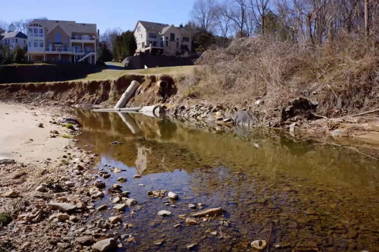
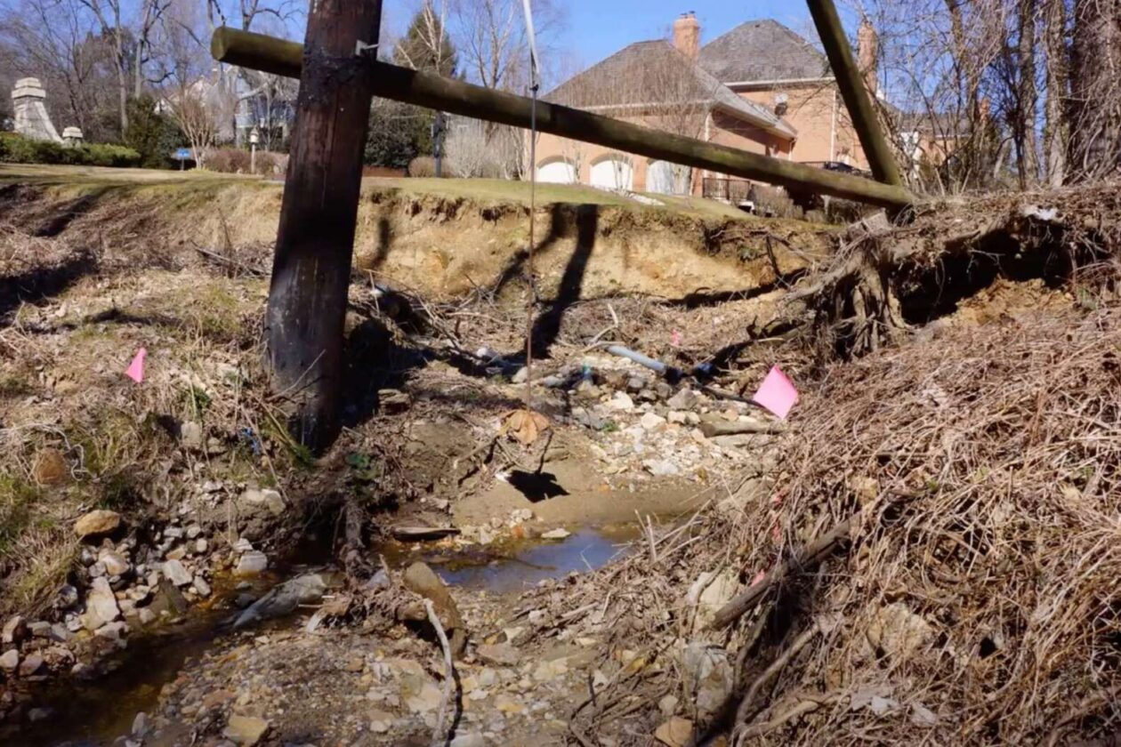
Fairfax County is designing restoration plans for an eroded stretch of Little Pimmit Run from Franklin Park Road to just upstream of Kirby Road in McLean.
The $9.23 million project will address 7,100 feet of degraded stream channel in addition to about 1,250 feet of tributaries, which will be restored so that they tie into the main channel of Little Pimmit Run.
“The water has a lot of energy and it’s causing a lot of erosion,” project manager Fred Wilkins said during a recent meeting.
According to Wilkins, the project aims to slow the speed of the water, which will protect infrastructure and area vegetation. It will also restore the ecology of the stream and the surrounding area, while preventing sediment and pollutants from flowing from Little Pimmit Run into the Chesapeake Bay.
Identified in 2019, other problems caused by the ongoing erosion include undercut banks and compromised trees, the county’s project page says.
Wilkins says another goal of the project is to protect infrastructure.
“There are multiple locations where we have sanitary pipes that cross the stream bed, and in some cases, the water can move debris that can damage the sanitary crossings, as shown during the 2019 storm, which caused emergency repairs to be needed,” he said.
Last but not least, the project manager said the county aims “to give the community something to enjoy.”
The project will unfold in two phases, starting with a stretch of stream from Franklin Park Road to Chesterbrook Road that runs parallel to Solitaire Lane. The second phase picks up north of Chesterbrook Road and goes away the way to Kirby Road.
 and phase 2 (right) of the Little Pimmit Run stream restoration project currently being designed (Image via Fairfax County)")
Right now, county officials are deliberating the future alignment of the channel. Once one is chosen, concept designs should be ready to be submitted this September 2021. A community meeting is slated for November.
There will not be a construction timeline until the designs are completed.
The project straddles private property and county property, and will require coordination between the county and property owners, Wilkins said.
People in the area can expect to see flagging and survey markers over the next several months, according to the county’s project website.
“Survey markers do not necessarily mean that the marked tree will be removed,” the website said.
This restoration work joins another stream restoration project along the channel between Forest Lane and North Albemarle Street, along with a sewer realignment project, emergency wastewater stabilization, and a Fairfax County Department of Transportation sidewalk project, Wilkins said.
")
The project is being funded through the county Stormwater Service District.
Images via Fairfax County