(Updated 9:10 a.m.) A Flash Flood Watch is in effect for most of the Washington, D.C., metropolitan area, including Fairfax County and Falls Church, on Christmas Eve tomorrow.
The watch will take effect Thursday afternoon and remain in place late into the night.
Here’s more from the National Weather Service, which issued the alert at 5:09 a.m. today (Wednesday):
* ONE AND HALF TO TWO AND HALF INCHES OF RAIN ARE EXPECTED THURSDAY AFTERNOON AND THURSDAY NIGHT. THIS IS EXPECTED TO RESULT IN FLASH FLOODING OF SMALL STREAMS AND CREEKS AND POSSIBLE RIVER FLOODING
Correction: This article initially, erroneously said the Flood Flood Watch would also be in effect on Friday.
Updated 9:50 a.m. — Aas a Flood Warning is in effect for the area until 3:30 p.m. today. NWS said that Vienna, Falls Church, Tysons and Merrifield may experience flooding.
Earlier: People can expect more thunderstorms and possibly heavy rain.
The National Weather Service issued a Flash Flood Watch for today (Thursday).
More from NWS:
Slow moving thunderstorms capable of producing heavy rainfall may develop today. Heavy rainfall from thunderstorms may lead to flash flooding.
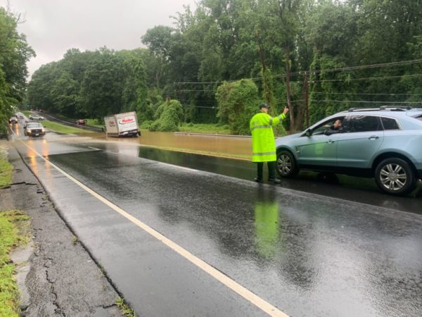
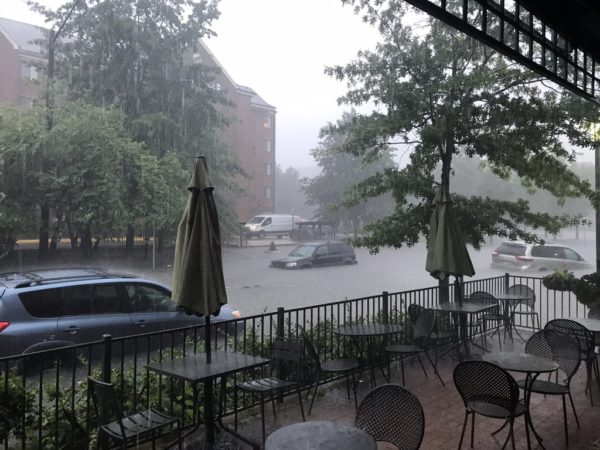
Potential impacts include rapid rises of water, flooded roads and flooding of structures in low lying areas near streams. Landslides and washouts are also possible.
People are advised to not drive through water they don’t know the depth.
Another flash flood watch is in effect for today. Multiple rounds of thunderstorms with heavy rain will be possible. pic.twitter.com/w40WR0SEvU
— NWS Baltimore-Washington (@NWS_BaltWash) August 13, 2020
Flash Flood Watch In Effect until midnight tonight (8/13)! If you must be on roads, never drive through a flooded roadway! PLEASE #TurnAroundDontDrown! Plan alternate routes around flooded roads. Don't put you, any passengers AND #FCFRD firefighters/paramedics in harm’s way! pic.twitter.com/xhoUAocquH
— Fairfax County Fire/Rescue (@ffxfirerescue) August 13, 2020
Get ready for another summer thunderstorm. A Flash Flood Watch will be in effect in Fairfax County this afternoon and evening.
The National Weather Service says that thunderstorms and showers could bring 1-2 inches of rain with some areas possibly getting up to 4 inches.
“A cold front will move into the area Wednesday and then stall out,” according to NWS. “Numerous slow-moving showers and thunderstorms will pose a risk of flash flooding.”
Flash Flood Watch expanded westward for today and tonight. pic.twitter.com/8DUzrASBwL
— NWS Baltimore-Washington (@NWS_BaltWash) August 12, 2020
Ahead of Tropical Storm Isaias hitting the D.C. region, Fairfax County officials and forecasters are sharing resources and tips to help people prepare for the storm.
“Significant flash flooding of small streams and creeks is likely tonight into Tuesday evening as rainfall associated with Tropical Storm Isaias spreads northward,” according to Fairfax County. Forecasters predict that the storm will bring 3-6 inches of rain.
Currently, the Tysons area is under a Tropical Storm Warning, which means that tropical storm-force winds are expected somewhere within this area within the next 36 hours,” according to National Weather Service.
The area will be under a Flash Flood Watch from 11 p.m. tonight to the same time Tuesday night and a Coastal Flood Watch will also be in effect from Tuesday morning to Wednesday.
Due to flooding risks, Fairfax County officials are reminding drivers to turn around if they see water and don’t know how deep it is. The county also tweeted out contact information for the appropriate people to call if someone spots a downed tree.
NWS wants people to protect property in flood-prone areas.
The Washington Post’s Capital Weather Gang tweeted that waves of heavy rain are expected to hit the D.C. region by Tuesday morning and that commuters should allow for extra time.
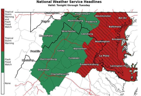
A Tropical Storm Warning has been issued for southern Maryland and nearby waters. A Tropical Storm Watch is in effect for other areas along and east of I-95. A Flash Flood Watch is in effect this evening through Tuesday evening. See https://t.co/5RyZgoXicj for further details. pic.twitter.com/keywY8cceB
— NWS Baltimore-Washington (@NWS_BaltWash) August 3, 2020
#Isaias and DC-MD-VA! Short thread…
* Tropical storm and flash flood watch out for large parts of the region
* High confidence in heavy rain. NWS has INCREASED our rain forecast to 4-6" along I-95 corridor, 2-4" to west, 5 to 7" east. (1/x) pic.twitter.com/en6NftxHD2— Capital Weather Gang (@capitalweather) August 3, 2020
Image via NWS Baltimore-Washington/Twitter
Updated 11:55 a.m. — The National Weather Service placed Fairfax County under a Tropical Storm Warning shortly after 11 a.m. today. “A Tropical Storm Warning means tropical storm-force winds are expected somewhere within this area within the next 36 hours,” according to NWS.
Earlier: As Tropical Storm Isaias hits the East Coast, forecasters warn that the Tysons area could see flash flooding early this week.
The Tysons area will be under a Flash Flood Watch from 11 p.m. tonight to the same time Tuesday night. “Moderate coastal flooding is possible at times of high tide Tuesday as Tropical Storm Isaias makes its closest approach to the area,” the National Weather Service said.
NWS says that widespread rainfall between 3-6 inches is expected, with possibly more in certain areas.
A Coastal Flood Watch will also be in effect from Tuesday morning to Wednesday.
“Rainfall associated with Tropical Storm Isaias is expected to start spreading northward late Monday night and continue into Tuesday evening,” according to NWS.
Forecasters encourage people to protect flood-prone property as soon as possible and monitor the weather. People should not attempt to drive through water if they don’t know how deep it is.
A Tropical Storm Warning has been issued for southern Maryland and nearby waters. A Tropical Storm Watch is in effect for other areas along and east of I-95. A Flash Flood Watch is in effect this evening through Tuesday evening. See https://t.co/5RyZgoXicj for further details. pic.twitter.com/keywY8cceB
— NWS Baltimore-Washington (@NWS_BaltWash) August 3, 2020
Portions of Northern Virginia including the Tysons area will be under a Flash Flood Watch starting Tuesday afternoon.
The National Weather Service said that the watch will be in effect from 3-11 p.m. Forecasters say that storms and gusty wind are expected today.
More from NWS:
A slow-moving cold front will intersect a hot and humid air mass resulting in scattered to numerous showers and thunderstorms late this afternoon and evening. Multiple rounds of thunderstorms are possible, which could result in isolated rainfall amounts of 2 to 3 inches in a short amount of time. These rainfall amounts may result in rapid rises of water on small streams and creeks, as well as in urban and poor drainage areas.
Sct'd showers & t'storms this afternoon/evening may contain gusty winds, flooding rain and frequent lightning, especially east of the Blue Ridge into the DC metro. pic.twitter.com/WQZhOwBAwL
— NWS Baltimore-Washington (@NWS_BaltWash) July 28, 2020
Updated at 3:35 p.m. — NWS has issued a Flash Flood Warning for the Tysons area. The warning is in effect until 6:30 p.m.
More from NWS:
At 330 PM EDT, Doppler radar indicated thunderstorms producing heavy rain across the area. Up to two inches of rain have already fallen in portions of the area, and rainfall amounts around 2 to 3 inches are expected within one hour. Flash flooding is ongoing or expected to begin shortly.
Earlier: Tysons and surrounding areas are under a Flash Flood Watch today.
The National Weather Service issued the watch shortly after 1:30 p.m. The watch will be in effect until 11 p.m.
According to NWS, heavy rainfall of 1-3 inches is expected to fall within an hour, possibly leading to flash flooding in local areas.
The Tysons area is also under a Heat Advisory and Severe Thunderstorm Watch this afternoon and evening.
Flash Flood Watch until 11 PM pic.twitter.com/GA144bSV5g
— NWS Baltimore-Washington (@NWS_BaltWash) July 22, 2020
The National Weather Service wants people in Fairfax County to prepare for storms today (Monday).
The area is under a Flash Flood Watch from 3-9 p.m. and a Severe Thunderstorm Watch from now until 11 p.m.
More from NWS about the Flash Flood Watch:
Thunderstorms will develop this afternoon and continue this evening along the I-95 corridor. Some areas may experience multiple thunderstorms through this evening. Rainfall amounts of 1-2 inches are possible, with some isolated amounts over 3 inches possible. This amount of rain over urban areas may lead to instances of flash flooding, as well as a potential for creeks and streams to rise rapidly if some of the higher amounts are realized.
Another, possibly stronger and more widespread round of thunderstorms is expected this afternoon/evening. A Flash Flood Watch is in effect for the areas highlighted in green on map 1. Also, the threat level for severe weather has been increased across the areas in yellow on map 2 pic.twitter.com/JvPr1GcDKO
— NWS Baltimore-Washington (@NWS_BaltWash) July 6, 2020
Severe Thunderstorm Watch for this afternoon and evening. pic.twitter.com/6CwJvsZBIm
— NWS Baltimore-Washington (@NWS_BaltWash) July 6, 2020
Work is underway to get flood-damaged Kirby Road in McLean reopened before the end of the year.
At a meeting hosted last night (Thursday) by Dranesville District Supervisor John Foust, officials from the Virginia Department of Transportation told attendees about the process behind reopening Swinks Mill Road and about the work done on Kirby Road.
The 1300 block of Kirby Road and Swinks Mill Road by Scott’s Runclosed due to severe storm damage from July 8 flash flooding. Swinks Mill Road reopened last week.
Kirby Road was damaged in two places from the storm — the roadway and the bridge. For about 12 hours after the storm, 21 homes were landlocked.
VDOT was able to restore access to the homes by 2 a.m. on July 9, VDOT official Denise Cantwell said.
After some delays with the bidding process, Martins Construction Corporation was awarded the $2.1 million emergency contract for repairs, Cantwell said.
The roadway work is expected to done by mid-November and then the crews will switch over to the bridge to get that done by mid-December. The date to get everything back open is Dec. 15.
To get the work done as soon as possible, VDOT has incentivized the contractor by offering up to $2,000 for every day completed early — capped at $120,000. And if the contractor goes past the Dec. 15 deadline, they will then have to pay $2,000 for every day the project is late.
Cantwell said that work cannot be done simultaneously on the bridge and roadway because then access would be cut off to the 21 homes again.
Work to add surface asphalt and striping is expected to be completed by May 2020. The work is dependent on the weather, Cantwell said.
One Fairfax County official is urging the county to take more responsibility for stormwater management regardless of its liability.
Dranesville District Supervisor John Foust represents McLean, Great Falls and Herndon on the Board of Supervisors. After major flash flooding in July, Foust saw severe storm damage throughout McLean — from two severely damaged roads to flooded yards and fields.
“This is the issue de jure out in the communities after July 8, at least in my neck of the woods,” Foust said. “This is what I hear about all the time.”
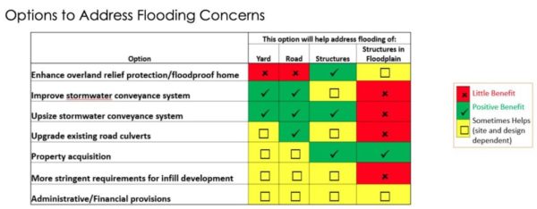
Randy Bartlett, the director of the county’s Department of Public Works and Environmental Services, gave a presentation to the Board of Supervisors about flood mitigation activities on Tuesday (Oct. 8).
Some of Bartlett’s proposed policy recommendations included using 100-year storm benchmarks when upsizing pipes, requiring new developments to capture a certain amount of rain and designating overland relief paths on plats.
“I think that these are good recommendations,” Chairman Sharon Bulova said, adding that the county needs to designs for the 100-year storm and consider upsizing at new developments.
Foust agreed with Bulova and said that Bartlett suggested “some good alternatives,” before pushing the county to do more.
Bartlett said that the county will install backflow valves that residents then need to maintain.
“I know we offer constituents options to make investments to limit the ability of our sewer systems to back up into their basements when our sewer systems get overflowed with stormwater,” Foust. “I think that should be our responsibility.”
Foust added that the county either needs to find a way to keep stormwater out of the sewer systems or — if it does — to at least make sure it doesn’t get into constituents’ basements.
Overland relief is causing dangerous situations, Foust said.
“We have to think about getting more of this water into a conveyance system that is not free-flowing in these neighborhoods,” he said.
Aside from the county’s efforts, Foust also said that more state funding is needed.
“We have neighborhoods being literally destroyed when it rains hard,” Foust said.
Photo via @SteveML9022/Twitter, graph via Fairfax County


