")
(Updated at 4:25 p.m.) The Fairfax County Department of Transportation got an initial round of public input last week on its study to improve pedestrian and bicycle safety and infrastructure in the area around the West Falls Church Metro station.
The department held virtual meetings on Wednesday and Saturday (Feb. 9 and 12) on the study as the county hopes to address community concerns before developers begin to transform the 24-acre transit station area, attracting more foot and vehicle traffic to the area.
FCDOT planner Timothy Kutz Jr. explained that the study focuses on a 2-mile radius around the Metro station to find gaps in the bicycle network. The study’s scope also encompasses a 1-mile radius for possible pedestrian improvements.
After the presentation, attendees brought up a range of issues, from missing sidewalks to the need for safer crossing methods. Areas of concern included access to the Metro station and nearby Haycock Elementary School, among other destinations.
One example of the need for increased safety was Redd Road, where participants raised concerns about the lack of sidewalks and safe crossing points as well as potential traffic dangers.
According to the study description, improvements there could include a walkway and a bridge that would connect to Redd from both the Idylwood Road and Pimmit Drive sides of the street.
Attendees also questioned if the planned development will make local traffic denser and more hazardous.
“We will be looking at forecasted volumes on select streets in order to determine how a change in traffic given increased development may affect the recommendations we make for active transportation improvements,” Kutz said.
The county launched the study in December after the Board of Supervisors approved comprehensive plan changes in July to allow mixed-use development around the West Falls Church Metro station and the Virginia Tech campus.
The plan allows for a maximum of 1,340 residential units, 301,000 square feet of office space, 48,000 square feet for retail space, and 160,000 square feet for institutional needs.
According to the project’s draft scope of work, the first set of recommendations will be ready to present for community feedback sometime this spring. A final draft of the study is projected to go before the Board of Supervisors in the summer.
Photo via Google Maps
With plans to develop the West Falls Church Metro station area now in place, Fairfax County has decided to evaluate how to improve the surrounding transportation network so it can actually accommodate the anticipated growth.
The Fairfax County Department of Transportation will kick off a West Falls Church Active Transportation Study at 7 p.m. today (Monday) with the first meeting of a new citizens’ advisory group.
The study will focus on the pedestrian and bicycle infrastructure in and around the West Falls Church Transit Station Area, which is bounded by I-66, the Dulles Toll Road, Haycock Road, and the Falls Church City border near Route 7.
“The ultimate goal of the study effort will be to improve pedestrian and bike access and safety around the Metro station,” Dranesville District Supervisor John Foust said by email. “To the extent located in the study area, safe access to several schools, including Lemon Road and Haycock [elementary schools] in the Dranesville District, will also be considered.”
The Fairfax County Board of Supervisors directed staff to create an active transportation plan in July after approving an amendment to the county’s comprehensive plan that allows more mixed-use development in the West Falls Church TSA.
While Virginia Tech halted plans to redevelop its West Falls Church campus earlier this year, the Washington Metropolitan Area Transit Authority officially signed an agreement with developers in August to bring over 1 million square feet of residential, retail, and office space to the TSA.
Coupled with Falls Church City’s impending West Falls project, the development could draw an influx of residents and traffic that has community members pushing the county to address existing safety challenges and enhance streets and sidewalks not built to support the increased density.
The West Falls Church Active Transportation Study will identify possible projects to improve safety, accessibility, comfort, and connectivity for bicyclists, pedestrians, and other non-motorized travelers, according to a draft scope of work.
In addition to providing “multiple opportunities for community input,” county staff will conduct an assessment of existing facility gaps and barriers to access in conjunction with the 13-person advisory group, which will consist of:
- Three representatives each from the Dranesville and Providence districts
- Two representatives each from Dranesville and Providence school PTAs in the study area
- One representative each from the McLean Citizens Association, Providence District Council, Fairfax Alliance for Better Bicycling, and Fairfax Families for Safer Streets
The citizen group will be assisted by a technical advisory group with local and state transportation, schools, parks, and police officials as well as one representative each from Metro, the City of Falls Church, and Virginia Tech.
Noting that the study will encompass both sides of Route 7, Foust points to Haycock Road between Great Falls Street and the Metro station as one area he anticipates will get a lot of attention.
“The sidewalk is very narrow and needs to be improved,” he said. “I also expect [the advisory group] will identify many intersections where we need to improve pedestrian and bicycle safety.”
A tentative timeline for the study has an initial public meeting taking place this winter, followed by the completion of the existing conditions assessment in the late winter or early spring. A final report with recommendations is scheduled to go to the Board of Supervisors in summer 2022.
Foust says the study will establish priorities among the identified projects, which could be funded privately through the county’s rezoning process or compete for public money.
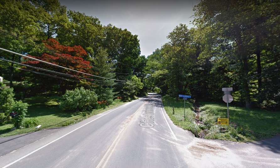
Fairfax County’s plan to build more sidewalk on Chesterbrook Road was received warmly by the McLean residents who joined a virtual community meeting last Wednesday (Nov. 17).
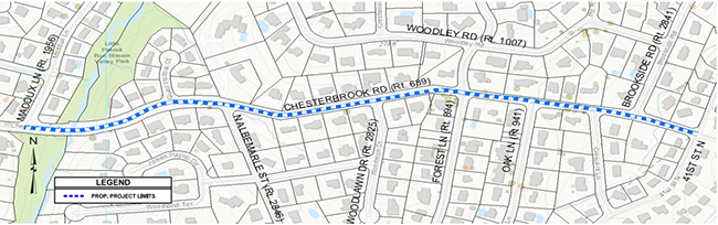
The Chesterbrook Road Walkway project will add about 3,200 feet of concrete sidewalk with curb and gutter on the south side of the street — also known as Route 689 — from Maddux Lane to 41st Street on the Arlington County border.
The new sidewalk will extend a recently completed segment between Maddux and Kirby Road to create a continuous pedestrian facility on the narrow but heavily used road lined with single-family houses.
“In my exercising, I walk along this stretch of highway several times a week, and I’m well aware of the problems and the need for this sidewalk,” 35-year McLean resident Rich Cohen said.
Designed as a country road, Chesterbrook has evolved into a key route for commuters between McLean and Arlington. Plans to redevelop downtown McLean could further widen the gap between the needs of area residents and drivers.
The existing road design presents a number of obstacles, including the limited shoulder width, drainage issues, and utilities and landscaping that need to be relocated or cleared, Fairfax County Department of Transportation project manager Mark VanZandt noted.
While no major modifications are proposed, the roadway will need to be slightly widened in three spots to accommodate off-tracking vehicles. More pavement will be added, but the travel lanes will actually go from 12 feet wide to 11 feet, according to consultant Adam Welschenbach.
“This is to ensure that vehicles stay in their lane and do not drive over pedestrians,” he said.
Currently in the preliminary stages of the design process, the sidewalk itself will be 5 feet wide with a roughly half-foot buffer between the pavement and the curb.
The project will add eight ADA-compliant curb ramps, with crosswalks at Forest Lane and Brookside Road. Those locations were chosen because of their proximity to a lot of houses, Fairfax County engineer Masoud Hajatzadeh said.
FCDOT anticipates that the project will require temporary grading easements from 23 properties. The county also plans to modify and reconstruct 14 driveway entrances to accommodate the new sidewalk.
")
Staff have not done a tree inventory yet, but VanZandt acknowledged that some clearing is inevitable, given the nature of the project, and the county won’t have the right-of-way needed to replant the trees.
“We do compensate homeowners for tree loss when the tree is on their property during land acquisition process,” VanZandt said. “I know the removal of a tree, it’s difficult to replace.” Read More
")
Lorton Pharmacy Gave Adult-Sized COVID-19 Vaccine Dose to Kids — The Fairfax County Health Department advises families whose children got the vaccine between Nov. 2 and 10 from the KC Pharmacy in Lorton to monitor for side effects and talk to a health care provider. The pharmacy is under investigation by the Virginia Board of Pharmacy and has been removed from the state and federal vaccination programs. [FCHD]
Sexual Assault Lawsuit Against FCPS Proceeds — A federal appeals court ruled in favor of a girl who filed a Title IX lawsuit against Fairfax County Public Schools over its handling of sexual harassment and rape allegations from when she was a student at Rachel Carson Middle School from October 2011 until February 2012. The lawsuit is one of two facing FCPS, which also has three outstanding federal investigations. [Inside NoVA]
NoVA Public Health Officials Urge Caution During Holidays — “Although Northern Virginia localities have some of the highest vaccination rates in the state, there is still substantial transmission of COVID-19 in the community, and we must remain vigilant to protect those who are not eligible for vaccination and those at higher risk for serious illness.” [VDH]
Public Meeting on McLean Sidewalk Project Tonight — “The Fairfax County Department of Transportation (FCDOT) will hold a virtual community meeting on Wednesday, Nov. 17, 2021, at 7 p.m., to present updates on the Chesterbrook Road Walkway Project from Maddux Lane to North 41st Street. The project is intended to provide a continuous pedestrian facility along the south side of the roadway from Maddux Lane to 41st Street.” [FCDOT]
Local Restaurants Generate Heat — “Tysons restaurants, Wren and Leila were recently featured in ‘The 16 Hottest New Restaurants Around D.C.,’ according to @Eater_DC. Both restaurants offer a variety of eclectic cuisine and specialty cocktails, perfect for any occasion.” [Tysons Partnership/Twitter]
")
County to Seek Input on Safe Streets Program — The Fairfax County Department of Transportation will hold two virtual public meetings in November to present draft recommendations for a Fairfax County Safe Streets for All Program. Developed by county’s ActiveFairfax team, the program is “a comprehensive initiative to address systemic transportation safety issues for people walking, biking and using other forms of active transportation.” [FCDOT]
Virginia Among Top States in COVID-19 Vaccinations — “Virginia now ranks 10th among all states for the percentage of its population fully vaccinated against COVID-19, and for the total number of shots administered. More than 82 percent of individuals 18 years and older have received at least one dose and 74 percent of adults are fully vaccinated.” [Office of the Governor]
Local Magnet School Admissions Now Open — “Thomas Jefferson High School for Science and Technology…has opened its application process for admissions for the Class of 2026. This will be the second year that applications for the school’s 550 freshmen seats will be reviewed using the new admissions process which eliminated the standardized admissions test and the $100 application fee, while continuing to maintain the school’s high academic standards.” [FCPS]
Madison Student Launches Art Business — “A business showcasing the art of Madison High School students is looking to build connections with Vienna area businesses by offering professional artwork services. Spectra Artwork is the brainchild of Madison High School senior Colin Crowley, combining his skills in business and marketing with the talents of his artist friends.” [Patch]
McLean Startup Raises Funds for Healthcare Jobs App — “ShiftMed, one of the largest workforce management platforms in health care with over 60,000 credentialed health care professionals, has raised $45 million led by health care investors, Panoramic Ventures and Heathworx…In 2021, the company has already hired more than 10,000 nurses, which provided over 1 million hours of care, and received more than 100,000 app downloads.” [ShiftMed]
")
If someone wanted to take a bus from Tysons to Springfield right now, they would have to sit through dozens of stops to travel the roughly 15 miles from north Fairfax County to the south.
The Fairfax County Department of Transportation hopes to change that by adding a 400X express route that would travel between the Tysons and Franconia-Springfield Metro stations via Gallows and Backlick roads.
Among the busiest corridors in the county, Gallows and Backlick are currently served by Fairfax Connector Routes 401 and 402, but even though they span a sizable area, those routes provide more localized service with frequent stops.
“With over 100 stops on this route, passengers traveling longer distances may have a slower trip,” Fairfax County Department of Transportation spokesperson Robin Geiger said by email. “The limited stop 400X bus route addresses this issue by significantly reducing travel time in the corridor between Tysons and Franconia-Springfield.”
The Fairfax County Board of Supervisors voted on Sept. 14 to approve Route 400X as one of seven projects recommended for funding from the Northern Virginia Transportation Authority for fiscal years 2022-2027.
Compared to the “Ring Road” project at Seven Corners, which was also in the $620 million package, the $10 million requested for the new Connector route is modest, but it would buy eight new buses, covering the entire estimated cost of the proposal.
As envisioned by the county, the new express route would provide bus service between the Tysons, Dunn Loring-Merrifield, and Franconia-Springfield Metro stations during peak hours, with a peak frequency of 20 minutes, according to FCDOT staff.
In addition to speeding up Connector trips between Tysons and Springfield, the proposed route would increase access to those areas from Annandale and help Metrorail riders who currently have to leave the county to transfer between the Orange, Blue, and Silver lines, Geiger says.
FCDOT has recommended adding a limited-stop route to enhance capacity on Routes 401 and 402 since at least 2009, according to the county’s 2016 Transit Development Plan.
According to the plan, which recommends transit improvements for fiscal years 2016-2022, Fairfax Connector increased the frequency of its service on those routes in 2014 when the first phase of Metro’s Silver Line opened, but trips can still take as long as 100 minutes during peak travel times.
With more than 108,604 people living in the I-495/Gallows Road corridor and over 176,800 jobs located there, Route 400X is part of a Franconia-Springfield bus service review that FCDOT conducted last year to see how Fairfax Connector could evolve to accommodate the area’s anticipated growth.
“This 400X route will address future travel demand in the corridor through a multi-modal response that enhances connectivity,” Geiger said, noting that the county also plans to expand Capital BikeShare and add bicycle routes. “…The route will also benefit from its connection to the Tysons Circulator routes that distribute trips to employment centers in the Tysons area.”
The review overlaps with a similar evaluation of the Tysons area that proposes several new and modified routes. Both studies will be incorporated into a Transit Strategic Plan that FCDOT is developing and expects to be adopted by the Board of Supervisors in 2022.
“If funded and approved by the Board of Supervisors, [Route 400X] is anticipated to become operational in 2023,” Geiger said.
")
The Fairfax County Department of Transportation has extended the Oct. 18 deadline for its community survey on proposed changes to bus service in Centreville, Chantilly, Vienna, Tysons, and neighboring areas, including McLean and Falls Church.
The online survey, which is available in English and Spanish, will now be open until next Wednesday (Oct. 27).
Unveiled at virtual public meetings on Sept. 30 and Oct. 7, the preferred plan will enable Fairfax Connector to serve more people, reduce travel times, maintain more reliable schedules, and provide more access to key destinations in the area, according to FCDOT.
“We encourage people to take the survey so they can tell us what is most important to them in the preferred bus plan for the Centreville, Chantilly, Vienna and Tysons areas,” FCDOT Transit Planning Chief Michael Felschow said. “The service belongs to our riders and our goal is to make it dependable, convenient and on-time.”
Fairfax Connector launched its review last year as part of a broader effort to identify service improvements that could be made throughout the transit system. So far, the evaluation has also included looks at the Franconia-Springfield area as well as Reston and Herndon.
County officials initially presented three possible plans: one similar to existing service patterns, one that completely overhauled the service area, and a hybrid. The preferred plan now under consideration is the product of revisions based on community feedback.
The proposed plan encompasses 24 bus routes, including several involving the Tysons area:
- Route 427 (North Tysons-Spring Hill): A new route between the Spring Hill Metro station and the McLean Governmental Center area, via Jones Branch Drive and Spring Hill Road
- Route 468 (Vienna-Reston): A new route between the Vienna and future Reston Town Center Metro stations, via Lawyers and Soapstone roads
- Route 660 (Centreville-Tysons): New, direct express service between the Centreville Park & Ride on Stone Road and the Tysons Metro station, via the Vienna station and I-495 Express Lanes
- Route 662 (Centreville-Vienna): New off-peak and weekend service between the Centreville Park & Ride and the Vienna Metro station, via I-66
- Route 671 (Chantilly-Vienna): New off-peak and weekend service with limited stops between Chantilly and the Vienna Metro station, via Route 50
- Route 722 (McLean-Langley): A new express route between the McLean Metro station and Langley, via Route 123/Dolley Madison Boulevard
Some existing routes in the plan will have better connectivity or more frequent service, such as Route 467 between Dunn Loring and Tysons and Route 461, which travels in a loop through Vienna and Oakton.
A full breakdown of the routes and service maps can be found on FCDOT’s website.
Fairfax Connector is also studying a “flex service concept area” in Vienna and McLean northwest of Route 123 “as a way to provide future on-demand service to and from the four Metro Stations within Tysons,” according to a map showing the preferred plan’s peak service routes.
According to FCDOT, the preferred plan will shave about a minute off the average travel time within the review area compared to its existing Connector service. It will also put an additional 2,700 people within a quarter-mile of the bus system.
The changes will provide more service to population and job centers as well as minority communities and households with an income at or below $50,000, according to the county.
Along with filling out the online survey, community members can also provide input by phone (703-877-5600), email ([email protected]), and mail (Fairfax County Department of Transportation, 4050 Legato Road, Suite 400, Fairfax, VA 22033).
")
(Updated at 9 a.m. on 10/20/2021) Fairfax County is currently developing an initial design for a new street envisioned as an alternative route into McLean from Tysons East that bypasses Route 123.
The Lincoln Street extension will connect Old Meadow Road with Magarity Road just east of the Dolley Madison Boulevard and I-495 interchange, crossing Scott’s Run Trail and cutting past Westgate Park and Westgate Elementary School.
Part of a larger grid of streets planned to accommodate the development expected to come to Tysons, the extension will help alleviate traffic congestion on Route 123 and give residents new access to neighborhood sites, such as the park and elementary school, as well as the McLean area, according to Fairfax County Department of Transportation Capital Projects Section Chief Michael Guarino.
“That provides a benefit to commuters by just relieving some pressure on those main thoroughfares and allows trips within Tysons to not always need to get on the main road that tends to have very heavy volume, especially during rush hour,” Guarino told Tysons Reporter.
The Lincoln Street project has been underway since at least 2019, when the Fairfax County Board of Supervisors approved $7 million to fund preliminary engineering work and a feasibility study.
Guarino confirmed that FCDOT has completed the feasibility study and is now updating a preliminary design in preparation for the first public meeting, which the project website says was previously expected to take place in the fall of 2020 but is now scheduled for January 2022.
While the COVID-19 pandemic didn’t directly contribute to the delay, county staff have been using the past year to coordinate with the Virginia Department of Transportation, which will ultimately own and maintain the new road.
Staff also revised the design to enhance the proposed bicycle and pedestrian amenities, Guarino says.
Improvements planned in the project include:
- Traffic signals at both the Old Meadow Road and Magarity Road intersections
- A 10-foot-wide asphalt, shared-use walkway on the northeast side of Lincoln Street
- A 6-foot-wide sidewalk on the south side of Lincoln Street
- Walkways along Magarity Road, which will connect to the Lincoln Street walkways
- A bridge over Scotts Run stream
According to Guarino, the design fits into Fairfax County’s “multi-modal” vision for the Tysons street grid, meaning it accommodates pedestrians, bicyclists, and transit, not just cars.
“We have design standards in place in Tysons that do give less weight to vehicular delays than we do in other parts of the county or statewide,” he said. “That’s to balance the needs for the other modes of transportation for a more urban environment.”
Guarino says he hasn’t heard any concerns yet about the new street contributing to cut-through traffic in the residential neighborhoods between Old Meadow and Magarity, though he acknowledged they could crop up at the upcoming public meeting.
The goal of the Tysons street grid is to address those issues by dispersing traffic throughout the area instead of concentrating it on just a handful of streets, which sends drivers looking to avoid the resulting congestion onto neighborhood roads, he explains.
“If you’ve got your major roads like Route 123 that are consistently getting backed up, that does tend to create a lot of cut-through traffic from other roads,” Guarino said. “So, if we can fill out the network, it distributes traffic…Lincoln Street itself won’t be cutting through the neighborhoods, but kind of connecting the neighborhoods, so I’m hoping it will be a benefit.”
The Lincoln Street project carries a total estimated cost of $39.9 million, according to county staff.
The Board of Supervisors voted on Sept. 14 to request $6.8 million from the Virginia Department of Transportation’s fiscal years 2027 and 2028 revenue-sharing program, which gives localities matching funds for highway construction, improvement, and maintenance projects.
The final design and right-of-way acquisition processes are expected to begin after the public meeting in January, with construction currently projected to start in late 2023 or early 2024.
")
There are few more self-evident testaments in Fairfax County to the shortsighted follies of 20th century land-use planning than Seven Corners.
The groundwork for the confounding convergence of Route 7, Route 50, Sleepy Hollow Road, Wilson Boulevard, and Hillwood Avenue in the Falls Church area was laid before the Civil War. Arlington Boulevard and Leesburg Pike emerged from early county roads that intersected at Fort Buffalo, according to a 2015 article by the Washington Business Journal.
A literal crossroads between Fairfax and Arlington counties and the City of Falls Church, the intersection became more intricate post-World War II, as the area saw a population and development boom, epitomized by the introduction of the Seven Corners Shopping Center, once the largest mall in the D.C. region.
According to The Washington Post, traffic was already a “major headache” in the early 1950s, and “state and local governments spent millions to alleviate” congestion when the mall opened in 1956. But conditions have kept deterioriating despite a patchwork of fixes implemented since then, including the addition of the Route 50 overpass near Patrick Henry Drive in 2009.
“It’s too complex. If you drive through now, you get stuck, everybody blocks each other, it doesn’t work,” Mike Garcia, the Fairfax County Department of Transportation’s planning section chief, told Tysons Reporter last week. “They’ve gone through and adjusted the signals many times. They’ve got it about as good as they’re going to get it.”
The Project
Since inverting time to undo this knot isn’t an option, Fairfax County is now trying to at least loosen it, and this time, it is willing to take the time to hopefully do it right.
As part of a larger package of funding requests, the Board of Supervisors voted on Sept. 14 to authorize transportation staff to seek $94.8 million from the Northern Virginia Transportation Authority for the first phase of a “ring” road that will eventually connect the west side of Route 7 to Wilson Boulevard.
The Seven Corners Ring Road project dates back to 2014, when a visioning task force charged with identifying possible land use and development improvements for the neighborhood recommended including the concept in a comprehensive plan amendment that the county board adopted on July 28, 2015.
According to Garcia, the county and task force considered six different options for improving the interchange, but they ultimately determined that a circular road looping through each of the main streets to create more traditional four-way intersections would be most effective.
“[It] would help at least clear up the area and make it a little more understood from the driver’s perspective, but also understood from the walking and biking perspective as well, because that’s as much the issue that we wanted to solve,” Garcia said. Read More
Starting over Labor Day weekend, transfers between Metro trains and Fairfax Connector buses will be free.
The Fairfax County Department of Transportation (FCDOT) said yesterday (Monday) it has partnered with the Washington Metropolitan Area Transit Authority (WMATA) to provide free transfers on nearly all Connector bus routes beginning on Sunday (Sept. 5).
This lines up with Metro’s new policy of also offering free bus transfers, which was first announced earlier this month.
“Fairfax Connector has historically aligned fare policies with Metrobus and by doing so, helps create a seamless experience for users when moving between transit services provided by WMATA and the County,” FCDOT spokesperson Robin Geiger wrote in an email. “That’s why we are partnering with WMATA to extend their program to Fairfax Connector bus service to provide good customer service and provide incentives to ride transit.”
The two exceptions will be the Fairfax Connector Express Service and the Wolf Trap shuttle. Both will be discounted by $2, though, with the use of WMATA’s SmarTrip card or app.
This is a pilot program that will operate for the next 10 months, through early July 2022, Geiger says.
Fairfax Connector serves all Metro stations located in Fairfax County. The transit system recently expanded service in the Falls Church area by taking over five Metrobus routes, four of which had ceased operations during the pandemic.
Additionally, the Wolf Trap shuttle will start again operating on Sept. 5. The shuttle runs between the West Falls Church Metro station and Wolf Trap National Park’s Filene Center.
The new policy is part of a larger push to encourage increased ridership on the Fairfax Connector as schools, offices, and other public places reopen amid the COVID-19 pandemic.
“We hope that when people go back to their workplaces, they consider returning to or trying transit for the first time,” writes Geiger. “Now, is the time to ride because the free transfer from Fairfax Connector to Metrorail or from Metrorail to Fairfax Connector saves money and because Fairfax Connector continues to provide a safe and healthy environment on buses.”
In May, county officials said they were reviewing possibly reducing or even eliminating fares altogether on the Fairfax Connector.
To help with this, the county was planning to apply for grant funds from Virginia’s Transit Ridership Incentive Program. The application deadline for the program is Sept. 17. Geiger says there’s currently no additional information on the possibility of reducing or eliminating fares.