Editor’s note: Tysons Reporter will temporarily have “Morning Notes” every weekday instead of twice a week to accommodate more news.
Local Paper Looking for Help — The Falls Church News-Press has been asking for donations from $25-$5,000 to help keep the paper operating under the COVID-19 pandemic. [Falls Church News-Press]
How One Local Faith Group is Adapting — “The ongoing COVID-19 public-health crisis has caused many organizations to regroup. Among them is Arlington/McLean Young Life Capernaum, which works with young people with special needs.” [Inside NoVa]
Local Students’ Research Lauded — “Emily Sun and Abigail Xu, students at Langley High School, have been selected as the 2020 recipients of the STEM Excellence Award bestowed by the McLean area branch of the American Association of University Women.” [Inside NoVa]
Shopper Limits at Harris Teeter — “Kroger Co. will limit the number of shoppers it allows in each of its stores across the country — including its Harris Teeter-branded stores — beginning Tuesday…The standard grocery store building capacity is one person per 60 square feet. Kroger will now limit capacity to one person per 120 square feet.” [Washington Business Journal]
Falls Church Officials Mull COVID-19 Impacts — “Although it is only a very preliminary assessment, the City’s chief financial officer Kiran Bawa presented to the Council two possible scenarios for the fiscal conditions facing the City, moderate and a severe estimates, with one having the City losing $1.3 to $3.9 million in revenues below earlier projections in the last four months of the current fiscal year, and $5.5 to $8.5 million in the Fiscal Year 2021 that begins July 1.” [Falls Church News-Press]
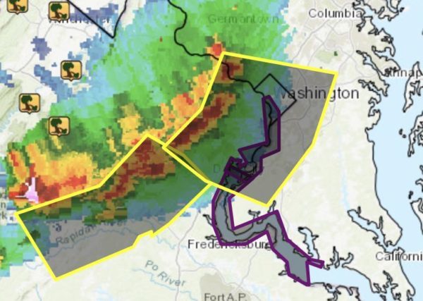
Severe Thunderstorms Possible — “Isolated severe storms are possible late this afternoon and evening for locations near and to the south and west of the Potomac River. Damaging winds and large hail are the primary threats. There is an isolated threat for severe thunderstorms overnight across the entire area.” [National Weather Service]
Severe thunderstorms are possible this afternoon and tonight. See image for more details. pic.twitter.com/s73E9gUzze
— NWS Baltimore-Washington (@NWS_BaltWash) April 7, 2020
The City of Falls Church is moving ahead on several efforts to address flooding issues.
City Manager Wyatt Shields told the City Council on Tuesday (Nov. 12) that 16 people have applied for the stormwater task force that the council approved back in October.
“We have had a very strong response to that,” Shields said about the advertisement for the task force, which can have up to seven members.
The deadline to apply is this Friday (Nov. 15), Shields said.
“We are looking for geographical diversity on this panel and the ability to have a city-wide perspective,” Shields said.
In response to residents’ comments that the task force should include sanitary sewer, Shields said that the rationale for not including that is because it is a different engineering problem, skillset and solution.
“To keep this work focused on stormwater was by decision,” Shields said.
When the task force is ready, Shields said that there will be an organizational meeting about the scope of the group.
Shields also pointed out some “big improvements” recently with stormwater management, including work on the washed-out flood wall at Tripps Run.
He added that work is underway to add water-tight man-hole covers in areas where water pools in the streets.
The city may also implement a program — similar to the one in Alexandria — to help homeowners considering a backflow device in their homes, Shields said.
“That would be a targetted program for areas where we have documented backflow where we can provide that assistance,” Shields said.
The program would need approval from the City Council, Shields said.
“That’s not the solution, but it does provide some additional resilience for homeowners,” Shields said, adding that he hopes the program will be available by the end of the calendar
Updated at 8:30 a.m. — Power has been restored.
Roughly 500 Dominion Energy customers are without power as a storm sweeps through the area on Halloween night.
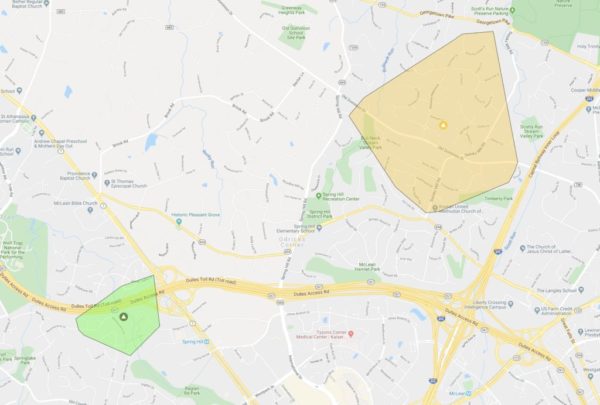
One power outage is affecting 326 customers in McLean, spanning from Georgetown Pike to Route 694 just west of I-495.
Another one is affecting 228 customers where the Dulles Access Road intersects with Leesburg Pike above the Spring Hill Metro station in Tysons.
The causes of the outages are pending investigation, according to Dominion’s outage map.
Map via Dominion Energy
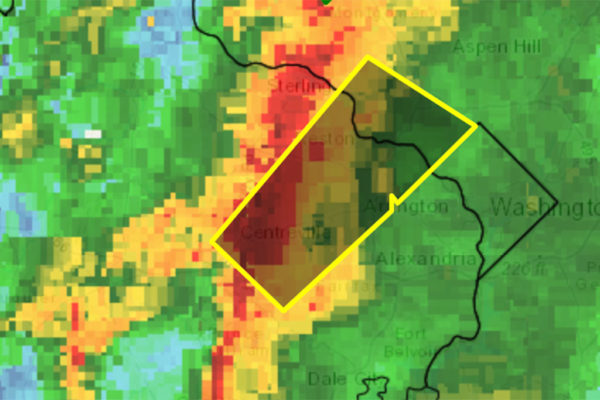
Update at 10:20 p.m. — A second Severe Thunderstorm has been issued, through 10:45 p.m.
10:10p: The second line of storms has triggered a Severe T’storm Warning (yellow box) for much of the DMV including the District until 10:45p with damaging winds possible. pic.twitter.com/wmZFcOgC7g
— Capital Weather Gang (@capitalweather) November 1, 2019
Earlier: Portions of Tysons, McLean, Vienna and Falls Church are currently under a Severe Thunderstorm Warning.
The warning is in effect until 9:45 p.m. The D.C. region remains under a Tornado Watch until midnight.
More from the National Weather Service:
THE NATIONAL WEATHER SERVICE IN STERLING VIRGINIA HAS ISSUED A
* SEVERE THUNDERSTORM WARNING FOR… SOUTH CENTRAL MONTGOMERY COUNTY IN CENTRAL MARYLAND… THE CITY OF FAIRFAX IN NORTHERN VIRGINIA… CENTRAL FAIRFAX COUNTY IN NORTHERN VIRGINIA…
* UNTIL 945 PM EDT.
* AT 908 PM EDT, A SEVERE THUNDERSTORM WAS LOCATED OVER CENTREVILLE, MOVING NORTHEAST AT 50 MPH.
HAZARD…60 MPH WIND GUSTS.
SOURCE…RADAR INDICATED.
IMPACT…DAMAGING WINDS WILL CAUSE SOME TREES AND LARGE BRANCHES TO FALL. THIS COULD INJURE THOSE OUTDOORS, AS WELL AS DAMAGE HOMES AND VEHICLES. ROADWAYS MAY BECOME BLOCKED BY DOWNED TREES. LOCALIZED POWER OUTAGES ARE POSSIBLE. UNSECURED LIGHT OBJECTS MAY BECOME PROJECTILES.
* LOCATIONS IMPACTED INCLUDE… CENTREVILLE, BETHESDA, RESTON, ANNANDALE, FAIRFAX, VIENNA, FALLS CHURCH, MANTUA, PIMMIT HILLS, AMERICAN LEGION BRIDGE, MCLEAN, POTOMAC, NORTH BETHESDA, OAKTON, CHANTILLY, TYSONS CORNER, WOLF TRAP, GREAT FALLS, MERRIFIELD AND CHEVY CHASE.
PRECAUTIONARY/PREPAREDNESS ACTIONS…
A TORNADO WATCH REMAINS IN EFFECT UNTIL MIDNIGHT EDT FOR CENTRAL MARYLAND…AND NORTHERN VIRGINIA.
REMAIN ALERT FOR A POSSIBLE TORNADO! TORNADOES CAN DEVELOP QUICKLY FROM SEVERE THUNDERSTORMS. IF YOU SPOT A TORNADO GO AT ONCE INTO THE BASEMENT OR SMALL CENTRAL ROOM IN A STURDY STRUCTURE.
FOR YOUR PROTECTION MOVE TO AN INTERIOR ROOM ON THE LOWEST FLOOR OF A BUILDING.
Severe Thunderstorm Warning including Centreville VA, Bethesda MD, Reston VA until 9:45 PM EDT pic.twitter.com/Yd3T39tjEM
— NWS Baltimore-Washington (@NWS_BaltWash) November 1, 2019
The National Weather Service has issued a Tornado Watch for Fairfax County and the D.C. region.
The Tornado Watch is in effect until midnight.
Storms with heavy rain and strong winds are expected to reach Fairfax County between 7-9 p.m., forecasters warn. Trick-or-treaters and Halloween party-goers should seek shelter.
The National Weather Service issued this statement:
…DAMAGING LINE OF THUNDERSTORMS LIKELY TO MOVE EAST ACROSS THE AREA BETWEEN MID AFTERNOON AND MIDNIGHT…
A line of thunderstorms is expected to move east across the region. These storms will bring the possibility of damaging wind gusts and isolated tornadoes. Please be sheltered when these thunderstorms pass through your area.
The most likely timing of the line ranges from mid to late afternoon for the Potomac Highlands, to the evening for the Baltimore/Washington metros, to between 9pm and midnight for areas east of I-95 to the Chesapeake Bay. The storms will likely last an hour or less in most areas.
Stay informed. For more exact timing for your location, consult the forecast for your community at our website weather.gov or our Facebook or Twitter feeds for National Weather Service Baltimore/Washington.
A line of thunderstorms is expected later this afternoon and evening. These thunderstorms may contain heavy rain, locally damaging wind gusts, & possibly a few tornadoes. See the second image for more detailed timing information. Stay weather aware & heed any warnings. pic.twitter.com/svF7kZczEw
— NWS Baltimore-Washington (@NWS_BaltWash) October 31, 2019
⚠️A tornado watch has been issued until midnight. A watch means current weather conditions may result in a tornado. Please stay alert and aware of tonight's forecast. https://t.co/dsuQfrcH8F
— Fairfax County Government 🇺🇸 (@fairfaxcounty) October 31, 2019
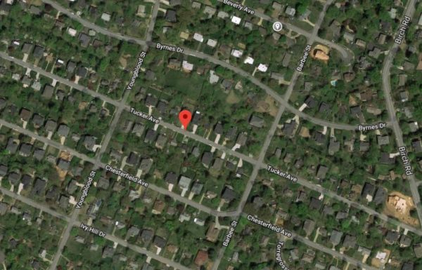
Design work is set to start at the end of the year to look for ways to reduce flooding in a McLean neighborhood.
The Tucker Avenue Neighborhood Stormwater project aims to reduce flooding and erosion, while improving stormwater drainage.
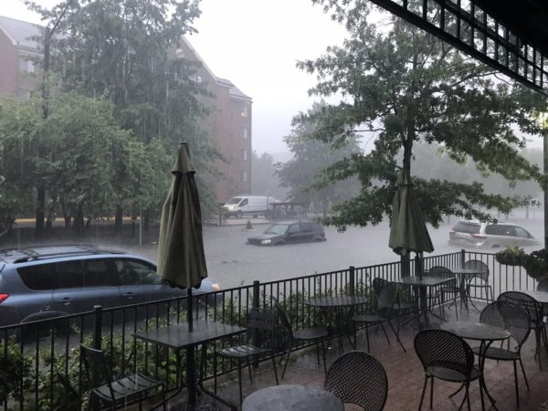
The area was reportedly damaged from severe flooding in July, along with several spots in McLean.
The project, which is located in the Pimmit Run Watershed, will look at the current drainage and stormwater infrastructure in the neighborhood and within a 67-acre drainage area that leads to Pimmit Run. The project is divided into three areas.
“All three areas have inadequate drainage systems that result in street, yard and/or house flooding during certain storm events,” according to Fairfax County. “Additionally, portions of lower Tucker Avenue are in a FEMA floodplain along Pimmit Run that creates further drainage problems.”
Fairfax County has teamed up with the Virginia Department of Transportation on the project, according to the county.
“A concept design is currently scheduled for late December or early January,” Dranseville District Supervisor John Foust said in an email.
So far, Foust was able to share that the project will upgrade the conveyance system and propose a new stormwater management system.
Foust has said that this is one of several projects meant to address flooding issues in McLean.
“Coordination with homeowners including [the] acquisition of additional storm drainage easements will be required prior to final design and construction,” according to Fairfax County.
Construction costs are expected to total $3.7 million and will be funded through Fairfax County’s Stormwater Service District fee.
New systems will be installed along VDOT’s right of way based on the neighborhood drainage pattern, Foust said.
Map via Google Maps
One Fairfax County official is urging the county to take more responsibility for stormwater management regardless of its liability.
Dranesville District Supervisor John Foust represents McLean, Great Falls and Herndon on the Board of Supervisors. After major flash flooding in July, Foust saw severe storm damage throughout McLean — from two severely damaged roads to flooded yards and fields.
“This is the issue de jure out in the communities after July 8, at least in my neck of the woods,” Foust said. “This is what I hear about all the time.”
Randy Bartlett, the director of the county’s Department of Public Works and Environmental Services, gave a presentation to the Board of Supervisors about flood mitigation activities on Tuesday (Oct. 8).
Some of Bartlett’s proposed policy recommendations included using 100-year storm benchmarks when upsizing pipes, requiring new developments to capture a certain amount of rain and designating overland relief paths on plats.
“I think that these are good recommendations,” Chairman Sharon Bulova said, adding that the county needs to designs for the 100-year storm and consider upsizing at new developments.
Foust agreed with Bulova and said that Bartlett suggested “some good alternatives,” before pushing the county to do more.
Bartlett said that the county will install backflow valves that residents then need to maintain.
“I know we offer constituents options to make investments to limit the ability of our sewer systems to back up into their basements when our sewer systems get overflowed with stormwater,” Foust. “I think that should be our responsibility.”
Foust added that the county either needs to find a way to keep stormwater out of the sewer systems or — if it does — to at least make sure it doesn’t get into constituents’ basements.
Overland relief is causing dangerous situations, Foust said.
“We have to think about getting more of this water into a conveyance system that is not free-flowing in these neighborhoods,” he said.
Aside from the county’s efforts, Foust also said that more state funding is needed.
“We have neighborhoods being literally destroyed when it rains hard,” Foust said.
Photo via @SteveML9022/Twitter, graph via Fairfax County
Falls Church residents may have noticed that work has started on several projects to minimize flooding damage and better manage stormwater.
City Manager Wyatt Shields gave the City Council an update on stormwater management projects at Monday (Sept. 23) night’s meeting.
Smaller ones, like drainage issues between Laura and Poplar drives and flooding issues at 913 and 915 blocks of Lincoln Avenue, will be handled in-house and paid for by the current stormwater operating budget, he said.
Residents can expect work to finish on those by the end of the year.
Meanwhile, the city has reached out to GKY about five larger watersheds, including:
- the area by W. Columbia Street and Shadow Walk
- the Hillwood Avenue area
- the Sherrow Avenue area
- E. Columbia Street and Harrison Branch Tributary
- Ellison Branch Stream near new homes on Lincoln Avenue
“Ultimately, we will get the options and get the costs and we will need to work together to prioritize our resources for where they can do the most good for the buck,” Shields said.
The timeframe will be determined during budget discussions in the winter, and work won’t begin on those larger projects until July, he said.
“People have been seeing us out in the field doing the initial walkthroughs with the engineers,” he said, adding that city staff is waiting to get a cost estimate from GKY before alerting the residents.
“It sounds like we’re making a lot of progress, I think if we can communicate better to those residents and let them know that work is happening, that would be very reassuring to people,” Councilmember Letty Hardi said.
The city has also been working to update its stormwater management plan after suffering severe damage from major flash flooding in July.
Shields also said that the wing wall on Tripps Run has been completed, eliminating a flooding risk to residents on Sherrow Avenue.
“It’s good to get that resolved,” he said.
The Tysons area is under a Severe Thunderstorm Warning, which includes the D.C. area.
The warning will last until 5:45 p.m. People can expect winds up to 60 miles per hour with “quarter size hail.”
More from the National Weather Service:
At 4:57 PM EDT, severe thunderstorms were located along a line extending from near Great Falls to Fairfax to near Bull Run, moving east at 25 mph…
IMPACT…Damaging winds will cause some trees and large branches to fall. This could injure those outdoors, as well as damage homes and vehicles. Roadways may become blocked by downed trees. Localized power outages are possible. Unsecured light objects may become projectiles.
Severe Thunderstorm Warning including Washington DC, Arlington VA, Alexandria VA until 5:45 PM EDT pic.twitter.com/tLVjgUjhhY
— NWS Baltimore-Washington (@NWS_BaltWash) September 11, 2019
A Severe Thunderstorm Watch is now in effect for Fairfax County.
The National Weather Service issued the watch at 3:25 p.m. today (Wednesday). It will last until 10 p.m.
A Severe Thunderstorm Watch (in pink) is in effect through 10 PM for the DC and Baltimore Metro areas due to the potential for damaging thunderstorms. The primary threat will be damaging winds. pic.twitter.com/MyK3aAULzB
— NWS Baltimore-Washington (@NWS_BaltWash) August 21, 2019


