")
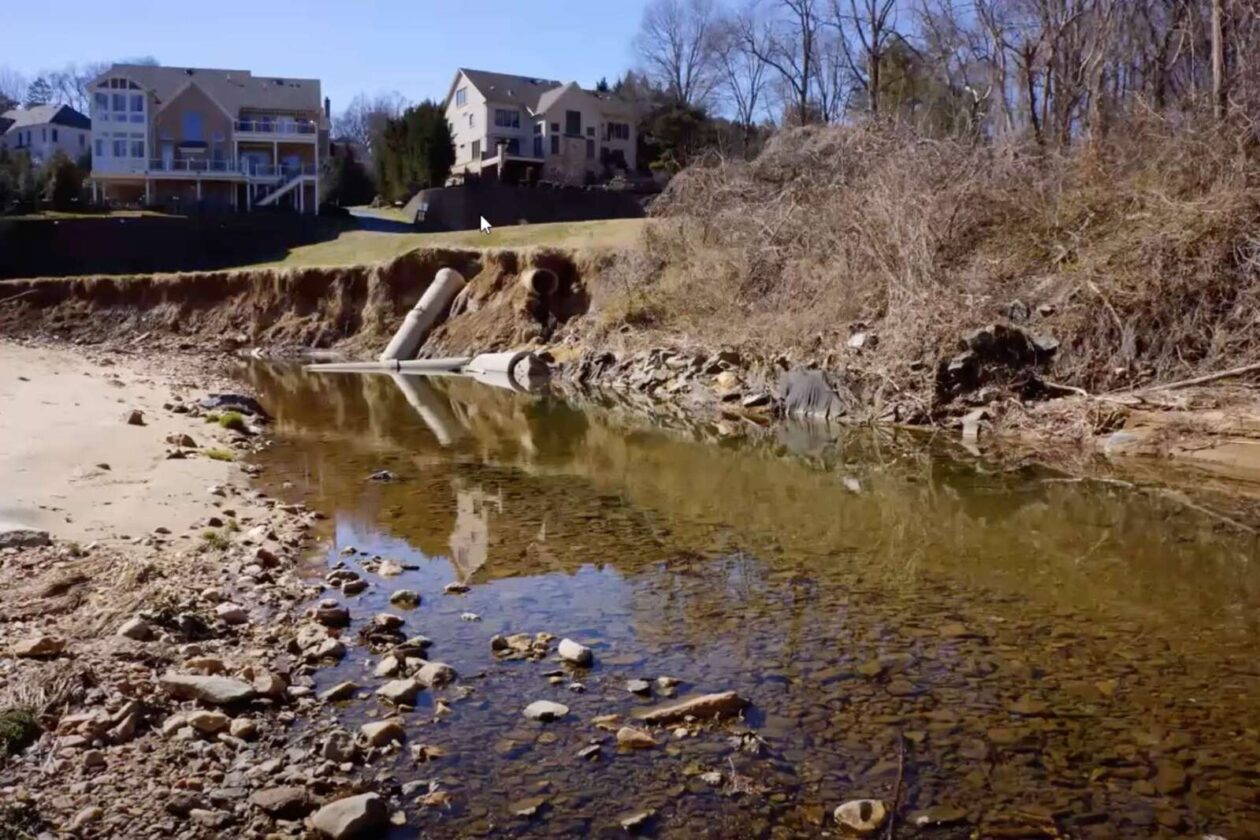
A townhome development planned for 7700 Leesburg Pike will include stormwater facilities intended to address flooding concerns in the nearby Pimmit Hills neighborhood.
The Fairfax County Planning Commission approved the more stringent plan for the site currently occupied by a circular office building on Nov. 10, determining that developer EYA met the county’s new standards to help prevent flood damage to nearby properties.
“We don’t want to have this development impact the downstream,” Commissioner Mary Cortina, who represents Braddock District, said during a Nov. 3 public hearing.
She noted that the property is not a big runoff producer today, but commissioners don’t want the proposed development to make flooding any worse.
The Board of Supervisors voted on Oct. 19 to adopt a comprehensive plan amendment allowing a residential project to proceed if it exceeded certain stormwater management standards to mitigate downstream flooding, among other factors.
Located on a hill, the four-story office was built in 1976 and includes professional and medical offices as well as a private college of nursing.
EYA is seeking to replace the office building with 104 townhomes, nine of which would be affordable dwelling units. The townhomes could be three stories high with optional fourth-story additions.
“Pimmit Hills has experienced a lot of problems with stormwater through the Pimmit Run watershed and through some of their sub watersheds,” said Dranesville District Commissioner John Ulfelder, who serves as the planning commission’s vice chair. “People have had flooded basements many times, and there’ve been lots of complaints.”
An engineer for the project conceded that the proposed development would make the site 12% more impervious, meaning it will have surfaces that produce runoff as opposed to vegetated areas that absorb water.
But the developer is pursuing several solutions to address stormwater issues, according to a county staff report.
That includes reducing possible discharges of phosphorous, which can be harmful to people and animals. EYA will provide two water treatment facilities to improve worst-case scenarios for different levels of flooding, including a 100-year-flood, which isn’t required.
According to the county report, the developer has committed in a proffer to meeting certain targets for stormwater runoff reduction:
The applicant proposes to reduce the 1-year site peak runoff rate to a minimum of 5% below the allowable release rate determined using the energy balance equation for sites draining to a natural stream. The site peak runoff rates for the 2-year event will be reduced below the peak runoff rates of the site as it exists prior to the current development by a minimum of 20%. The 10-year site peak runoff rate will be reduced to the peak runoff rate that would drain off the site if it has a forested condition. The 100- year site peak runoff rate will also be reduced a minimum of 10% below the peak runoff rate that would be released from the post-development site if it did not have any stormwater measures.
The Board of Supervisors will still have to give the final approval to the townhouse project, which Ulfelder said might not be scheduled this year.
The Fairfax County Planning Commission gave its support to a proposed comprehensive plan amendment last week that will let a developer replace an aging Pimmit Hills office building at 7700 Leesburg Pike with townhomes.
The vote to recommend approval of the amendment came only after two commissioners and county staff worked with EYA Development to secure stronger language regarding the prospective developer’s obligations to address existing stormwater management and flooding issues.
“I think we’re at a place where we need to be in terms of strengthening that language and beefing it up,” Dranesville District Planning Commissioner John Ulfelder said during the Oct. 6 meeting. “So, as the rezoning proceeds, we have some clear guidance based on the particular issues and problems that this site and sub-water shed present.”
Initiated by the Fairfax County Board of Supervisors on Sept. 15, 2020, the 7700 Leesburg Pike plan amendment process is unfolding in conjunction with a rezoning application that EYA submitted in December.
The developer has proposed building 104 single-family, attached townhouses — nine of which will be priced as affordable dwelling units — in place of the 150,000 square-foot office complex that currently occupies on the site.
The property is right on the edge of Pimmit Hills, which has encountered drainage and flooding challenges since construction began on the neighborhood in the 1950s, according to Ulfelder.
“People had muddy yards and so on,” he said. “Today, people — with some of the extraordinary rain events we’ve had — have had real problems with their basements and with their yards.”
Flood Factor, a tool developed by the nonprofit First Street Foundation, characterizes the overall risk of flooding in Pimmit Hills over the next 30 years as minor, but it says 174 properties, or 8% of all properties in the neighborhood, face a 26% or greater chance of being severely affected by flooding in that time frame.
")
In addition, the risk to residential properties and roads is increasing, with the latter already deemed at moderate risk of flooding, according to the database.
Fairfax County staff recommended in a report that the plan amendment include a provision requiring “stormwater management controls for the new development above the minimum standards are provided to the extent possible.”
However, Ulfelder and Braddock District Commissioner Mary Cortina raised concerns about what exactly that will entail at a Sept. 29 public hearing on the amendment. The commission decided to defer making a decision at that meeting.
“The feeling was, maybe the language that was being initially proposed didn’t go far enough in spelling out how we should proceed in order to try to reduce runoff,” Ulfelder said on Oct. 6.
The revised amendment includes a more specific explanation of the stormwater requirements that EYA will need to meet in order to get its proposed development approved:
Provide stormwater management controls above the minimum standards to the greatest extent possible to reduce runoff to good forested conditions; provide for an adequate outfall as informed by the Middle Potomac Watershed Plan; and to help mitigate downstream flooding.
EYA’s legal representative said at the public hearing that the developer plans to provide two facilities designed to capture water before releasing it at a slower rate, along with filters throughout the property that will improve the water quality.
The planning commission voted 10-0-1 to recommend that the Board of Supervisors adopt the revised amendment, with At-Large Commissioner Timothy Sargeant abstaining and Commissioner Candice Bennett not present.
The commission is scheduled to hold a public hearing on EYA’s rezoning application on Nov. 3.
Photo via Google Maps
")
Updated at 3 p.m. — Swinks Mill Road in McLean has reopened after floodwaters swept debris onto the bridge at Scott Run this morning.
Updated at 12:10 p.m. — A Tornado Watch has been issued for the D.C. area, including Fairfax County, until 7 p.m.
Updated at 11:30 a.m. — All activities scheduled to take place in Fairfax County Public Schools this afternoon and evening have been canceled due to the anticipated inclement weather.
Earlier: Several feet of water surrounded a car on a road in Wolf Trap this morning (Wednesday) after an overnight storm passed through Fairfax County, producing flooding with more rain expected to fall throughout the day.
The National Weather Service issued a Flood Warning at 8:35 a.m. today (Wednesday) for central Fairfax County and Northern Virginia that will be in effect until noon.
“At 8:35 a.m. EDT, stream gauges report water levels continue to rise from earlier heavy rain,” the NWS said in the alert. “Flooding is already occurring in the warned area. Between 1.5 and 2.5 inches of rain have fallen.”
A Flash Flood Watch is also in effect for much of the D.C. area through 8 a.m. tomorrow (Thursday).
Fairfax County officials warned people not to drive through flooded routes. It was unclear the extent of rescue efforts that occurred in Wolf Trap, which the county first described as Vienna. A spokesperson later said officials responded to the 9900 block of Browns Mill Road.
Officials closed several roads due to flooding, including Old Courthouse and Besley roads in Tysons, Fairfax County Police Department reported.
Locations expected to face flooding include Dunn Loring, Great Falls, Merrifield, Pimmit Hills, Tysons, and Vienna.
Scenes from a county road this morning in Vienna.
PLEASE do not drive through flooded roads. There's more rain coming our way today from #Ida.
Turn around, don't drown. pic.twitter.com/Lx6IE840gI
— Fairfax County Government 🇺🇸 (@fairfaxcounty) September 1, 2021
The Virginia Department of Transportation’s Northern Virginia District reported at 8:55 a.m. that Swinks Mill Road has been closed just north of Scott Run, posting a photo on Twitter of damage to a bridge over the stream.
McLean: Swinks Mill Rd is closed just north of the bridge over Scott Run. The bridge itself is fine. Crews will be removing debris and repairing the approach to the bridge. This is not expected to be a long-term closure. pic.twitter.com/cCUuvQN3fO
— VDOT Northern VA (@VaDOTNOVA) September 1, 2021
The flooding and rain come courtesy of Tropical Depression Ida, the remnants of the hurricane that slammed the Gulf Coast earlier this week.
While the storm is expected to become post-tropical today, it could still bring three to eight inches of rain with some higher amounts through Thursday, and significant and life-threatening flash flooding is likely in the mid-Atlantic, the NWS Weather Prediction Center said in a 5 a.m. bulletin.
“We are expecting several inches of rain today from the remnants of Hurricane Ida, picking up in intensity in the early afternoon until around midnight,” Fairfax County said in a post on its emergency information blog. “We have already experienced an early morning storm that has led to power outages, swift water rescues and numerous road closures due to downed trees and flooded roads.”
The Fairfax County Fire and Rescue Department is urging people to avoid driving through flooded or closed roadways, noting that stalled and trapped cars put the driver, passengers, and first responders in unnecessary danger.
“By now, many drivers across Fairfax County know which roads traditionally flood,” the department wrote in a blog post. “FCFRD asks that if you need to be on the roadways today that you stay informed and plan alternate routes around flooded roadways. Our firefighters and paramedics do not want to meet you by (a preventable) ‘accident’!”
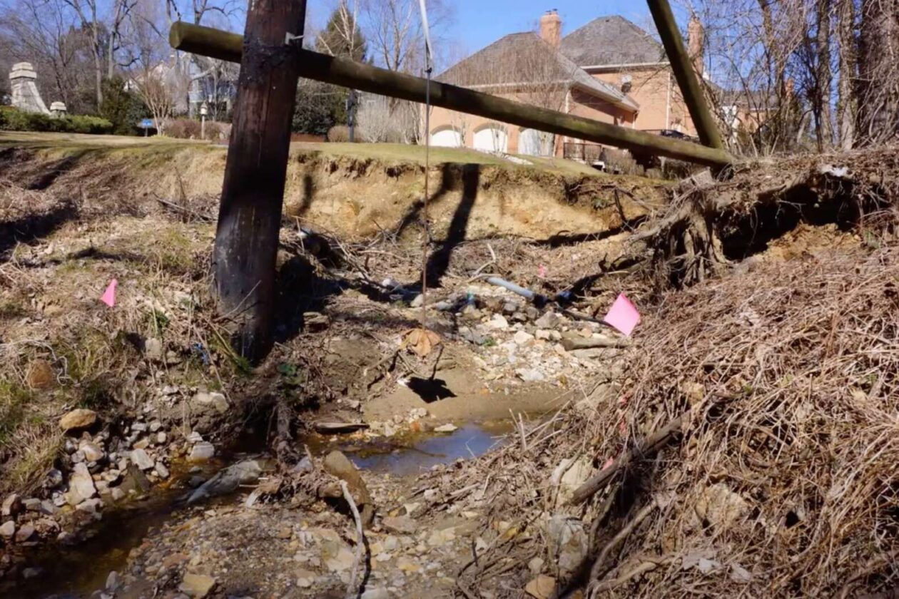
Fairfax County is designing restoration plans for an eroded stretch of Little Pimmit Run from Franklin Park Road to just upstream of Kirby Road in McLean.
The $9.23 million project will address 7,100 feet of degraded stream channel in addition to about 1,250 feet of tributaries, which will be restored so that they tie into the main channel of Little Pimmit Run.
“The water has a lot of energy and it’s causing a lot of erosion,” project manager Fred Wilkins said during a recent meeting.
According to Wilkins, the project aims to slow the speed of the water, which will protect infrastructure and area vegetation. It will also restore the ecology of the stream and the surrounding area, while preventing sediment and pollutants from flowing from Little Pimmit Run into the Chesapeake Bay.
Identified in 2019, other problems caused by the ongoing erosion include undercut banks and compromised trees, the county’s project page says.
Wilkins says another goal of the project is to protect infrastructure.
“There are multiple locations where we have sanitary pipes that cross the stream bed, and in some cases, the water can move debris that can damage the sanitary crossings, as shown during the 2019 storm, which caused emergency repairs to be needed,” he said.
Last but not least, the project manager said the county aims “to give the community something to enjoy.”
The project will unfold in two phases, starting with a stretch of stream from Franklin Park Road to Chesterbrook Road that runs parallel to Solitaire Lane. The second phase picks up north of Chesterbrook Road and goes away the way to Kirby Road.
 and phase 2 (right) of the Little Pimmit Run stream restoration project currently being designed (Image via Fairfax County)")
Right now, county officials are deliberating the future alignment of the channel. Once one is chosen, concept designs should be ready to be submitted this September 2021. A community meeting is slated for November.
There will not be a construction timeline until the designs are completed.
The project straddles private property and county property, and will require coordination between the county and property owners, Wilkins said.
People in the area can expect to see flagging and survey markers over the next several months, according to the county’s project website.
“Survey markers do not necessarily mean that the marked tree will be removed,” the website said.
This restoration work joins another stream restoration project along the channel between Forest Lane and North Albemarle Street, along with a sewer realignment project, emergency wastewater stabilization, and a Fairfax County Department of Transportation sidewalk project, Wilkins said.
")
The project is being funded through the county Stormwater Service District.
Images via Fairfax County
")
The National Weather Service issued a Flood Watch for much of the Washington, D.C., metropolitan area, including the McLean and Falls Church areas of Fairfax County, early Wednesday morning, forecasting a day of strange, wet weather for local residents.
The county is also under a winter weather advisory after the NWS predicted yesterday afternoon that the area will see between one and three inches of snow and sleet accumulation. That advisory is in effect from 10 a.m. today to 1 a.m. on Thursday.
According to the NWS, potential flooding could take place from 4 p.m. today through Thursday morning. The agency is projecting that the D.C. area will see one to two inches of rainfall, which could lead to isolated flooding, especially when coupled with earlier precipitation.
“You should monitor later forecasts and be alert for possible flood warnings,” the NWS said. “Those living in areas prone to flooding should be prepared to take action should flooding develop.”

A flood warning is in effect until noon today (Monday) for central Fairfax County, including Tysons, Vienna, Dunn Loring, and Merrifield.
As of 8:43 a.m., over an inch of rain has fallen in the county since late last night, according to the National Weather Service.
Old Courthouse Road has been closed at Besley Road in Vienna due to high water from Wolftrap Creek, and drivers should expect delays. The NWS says that Beulah Road at Browns Mill Road by Wolftrap Creek could also be prone to flooding.
“Turn around, don’t drown when encountering flooded roads,” the NWS says. “Most flood deaths occur in vehicles.”
Here is more from the NWS flood warning alert:
…FLOOD WARNING REMAINS IN EFFECT UNTIL NOON EST TODAY FOR CENTRAL
FAIRFAX COUNTY…At 843 AM EST, Over an inch of rain fell in central Fairfax County
late last night and early this morning. This resulted in Old
Courthouse Road in the area of Wolf Trap being closed. Stream gauges
in the area appeared to have crested and only minor additional
rainfall is expected through the remainder of this morning.
Update at 1:55 p.m. — The Fairfax County Police Department says that Lawyers Road is now closed due to flooding at Hunter Mill Road. Old Courthouse Road remains shut down.
Update at 12:30 p.m. — The National Weather Service has now upgraded central Fairfax County and the City of Fairfax from a flood watch to a flood warning, which will remain in effect until 4 p.m.
Old Courthouse Road closed at the Besley Road intersection in Wolf Trap at 10:45 a.m. due to ongoing flooding from Wolftrap Creek, and a NWS map shows that Rocky Run near Tysons also has a a 90% or higher chance of flash flooding.
As of 12:03 p.m., between one and two inches of rain have fallen in the county, and an additional one to two inches of rain could potentially fall in the area covered by the flood warning. Locations in the Tysons area that may be at risk of flooding include Tysons, Vienna, Wolf Trap, Great Falls, Merrifield, and Dunn Loring.
Earlier — A Flood Watch is in effect for most of the region until 10 p.m. today, according to the National Weather Service.
Remnants of Hurricane Zeta are expected to dump two to three inches of rain on the area.
NWS warns that heavy rain could lead to flooding of small streams, creeks, and urban areas. Clogged drains due to leaf buildup might also cause flooding issues.
Here’s more from the alert:
Do not enter or cross flowing water or water of unknown depth. Stay away or be swept away. River banks and culverts can becom unstable and unsafe.
A Flood Watch means there is a potential for flooding based on current forecasts. You should monitor later forecasts and be alert for possible flood warnings. Those living in areas prone to flooding should be prepared to take action should flooding develop.
The Fairfax County Fire and Rescue Department is advising drivers to plan alternate routes so they can avoid roads that tend to flood, noting that cars trapped on flooded roadways creates “needless danger” for drivers, passengers, and emergency responders.
“Our firefighters and paramedics do not want to meet you by (a preventable) ‘accident’!” FCFRD said.
In addition, the Fairfax County Park Authority is asking community members to call before visiting any golf courses, since some venues may be closed if there is indeed heavy rain.
Grab your umbrella ☔️ Rain 🌧️ from #Zeta is going to cause a wet commute for drivers today.
When driving in the rain remember
💡 headlights & wipers on
🚘 increase following distance
🐢 slow down
💧 #TurnAroundDontDrown
👁️ be alert for pedestrians & other road users pic.twitter.com/krPQMJhevB— VDOT (@VaDOT) October 29, 2020
")
(Updated 8/20/2020) A much-needed bridge replacement is on pause while the City of Falls Church waits to hear if the Virginia Department of Transportation will award the project funding.
Oak Street Bridge, which crosses Tripps Run, is in poor condition. Yearly inspections since 2012 have found several safety concerns and an urgent need to repair or replace the bridge.
While the bridge was repaired last year to fix damage from severe flooding, Falls Church officials want to replace it to make it safer and a better fit for the community.
A staff update to the Falls Church City Council last Monday (Aug. 10) on projects in the Capital Improvements Program (CIP) shared that the bridge replacement is the only CIP project that has stopped during the pandemic.
The CIP update noted that the city was expecting to hear back in May or June about its application to VDOT’s State of Good Repair (SGR) program for the remaining $928,000. As of last Monday, the city hasn’t heard anything.
“The SGR program is one of the very few funding sources available for paving and bridges that requires no match,” staff said in the update, noting that infrastructure funding was already competitive before the pandemic.
In November, city staff said that construction could begin in early 2021. The CIP update last week noted that the project design is 90% complete, but the funding shortfall is holding the project up.
Previously, the city announced that the $2.6 million replacement received partial funding through Regional Surface Transportation Program funds.
Aside from the bridge, the majority of the city’s CIP projects have progressed during the pandemic, with 18 on schedule and 11 facing delays. Since the last CIP update in January, the city finished two projects — sanitary sewer infrastructure in West Falls Church and primary extension paving along East Broad Street and Hillwood Avenue.
The city also added two new projects to the CIP list after the Northern Virginia Transportation Authority (NVTA) granted the total funding. One project received $6.9 million to address transit access and multimodal connectivity in West Falls Church. The other project, which received $8.3 million, will tackle multimodal improvements in the downtown area.
The CIP update last week noted that receiving the full funding for both projects was “unexpected, but much needed.”
Update corrects name of NVTA
Image via City of Falls Church
")
Prepare for more rain today (Friday).
A Flash Flood Watch is in effect from noon today through late tonight, according to the National Weather Service.
Here’s more from the alert:
PRECAUTIONARY/PREPAREDNESS ACTIONS…
A FLASH FLOOD WATCH MEANS THAT CONDITIONS MAY DEVELOP THAT LEAD TO FLASH FLOODING. FLASH FLOODING IS A VERY DANGEROUS SITUATION YOU SHOULD MONITOR LATER FORECASTS AND BE PREPARED TO TAKE ACTION SHOULD FLASH FLOOD WARNINGS BE ISSUED
More thunderstorms with heavy rain are expected today. A Flash Flood Watch is in effect again this afternoon and tonight for much of our area. pic.twitter.com/Fju53hs38d
— NWS Baltimore-Washington (@NWS_BaltWash) August 7, 2020
Updated 3:40 p.m. — The Fairfax County Police Department said around 3:30 p.m. that all of the road closures have been resolved.
Earlier: Several roads are closed in the Tysons area due to the storm.
The Fairfax County Police Department shared an updated list of weather-related road closures around the county this morning.
Currently, the Tysons area is under a Flash Flood Watch and Flood Warning today as Tropical Storm Isaias moves through the D.C. region.
Road closures:
- Old Courthouse and Besley roads: high water
- Old Dominion Drive and Swinks Mill Road: tree blocking the roadway
- Idylwood Court and Idylwood Road: tree on power line over the roadway
- Friden and Hillside drives: tree blocking the roadway
Browns Mill and Beulah roads: high water
Use the map below to find the Tysons-area road closures. Tysons Reporter will update this article and map as more information becomes available or if the road closures change.
Driving through flooded roadways can be deadly. Watch & share this @NWS video to see why: https://t.co/8oJR2M7tNs #TurnAroundDontDrown
— Fairfax County Government 🇺🇸 (@fairfaxcounty) August 4, 2020