(Updated at 9 a.m.) Bill Ending School Mask Mandates Signed — Gov. Glenn Youngkin signed legislation yesterday (Wednesday) letting parents opt their children out of mask requirements, adding an emergency clause that sets a deadline of March 1. Fairfax County Public Schools said in a statement to Tysons Reporter that it’s reviewing what this means for the district, which sued to keep its mandate. [Patch]
Wind Advisory Takes Effect Tonight — The National Weather Service has issued a Wind Advisory for Northern Virginia, including Fairfax County, that will be in effect from 10 p.m. today (Thursday) to 10 a.m. tomorrow. The alert warns that winds could reach 20 to 30 miles per hour with gusts of up to 50 miles per hour, potentially blowing down tree limbs and creating power outages. [NWS]
Tysons Area Schools to Hold Graduations in D.C. — Langley, Madison, Marshall, and McLean high schools will have graduation ceremonies at DAR Constitution Hall on May 31 and June 1 after the events were previously moved due to D.C.’s COVID-19 vaccine requirement, which ended Tuesday (Feb. 15). FCPS said the rule “would have prevented a number of students and families from attending.” [WTOP]
Seven Corners to Get New Fire Station — Fire Station 28 personnel moved to temporary quarters yesterday as Fairfax County prepares to tear the existing station down and build a new one in its place. The new building will have two levels and 13,500 square feet of space, and the current estimated occupancy is mid-2024. [FCFRD/Twitter]
Vienna Inn Named Top 10 “Lovable” Dive Bar — DC Eater ranked the longtime Town of Vienna staple as the 10th most lovable dive bar in the D.C. area: “Around since 1960, this Northern Virginia neighborhood institution is famous for its chili dogs and its convivial vibe. During the pandemic, the chill bar debuted curbside takeout, delivery, and heated outdoor seating.” [DC Eater]
Virginia Leans Red Again — “In blow to Democrats, Republican Glenn Youngkin defeated Democrat Terry McAuliffe in Virginia’s high-profile election for governor Tuesday, NBC News projects, flipping control of a state that President Joe Biden won handily just a year ago and suggesting trouble for his party in next year’s midterm elections.” [NBC News]
Limited Supplies of COVID-19 Vaccine for Kids Expected — Demand for pediatric COVID-19 vaccinations could outstrip supply, as in the early days of the vaccine’s rollout. The Fairfax County Health Department urges patience as it anticipates about 80,000 of the county’s 97,000 children aged 5-11 to seek out the vaccine in the next few months. [The Washington Post]
Vienna Police Participate in No-Shave November — “Typically, Vienna police officers have to follow a dress code that doesn’t allow male officers to have facial hair. This November, that rule will be suspended so officers can raise awareness about prostate cancer for the Grow-and-Give fundraising campaign.” [Patch]
Virginia Museum of Fine Arts Coming to Tysons — “We are delighted to team up with the @vmfamuseum to host their Artmobile outside @capitalonehall’s Box Office November 17th & 18th! Join us for a FREE exhibit of A View from Home: Landscapes of Virginia. Link in bio for more!” [Capital One Center/Instagram]

Updated at 3 p.m. — Swinks Mill Road in McLean has reopened after floodwaters swept debris onto the bridge at Scott Run this morning.
Updated at 12:10 p.m. — A Tornado Watch has been issued for the D.C. area, including Fairfax County, until 7 p.m.
Updated at 11:30 a.m. — All activities scheduled to take place in Fairfax County Public Schools this afternoon and evening have been canceled due to the anticipated inclement weather.
Earlier: Several feet of water surrounded a car on a road in Wolf Trap this morning (Wednesday) after an overnight storm passed through Fairfax County, producing flooding with more rain expected to fall throughout the day.
The National Weather Service issued a Flood Warning at 8:35 a.m. today (Wednesday) for central Fairfax County and Northern Virginia that will be in effect until noon.
“At 8:35 a.m. EDT, stream gauges report water levels continue to rise from earlier heavy rain,” the NWS said in the alert. “Flooding is already occurring in the warned area. Between 1.5 and 2.5 inches of rain have fallen.”
A Flash Flood Watch is also in effect for much of the D.C. area through 8 a.m. tomorrow (Thursday).
Fairfax County officials warned people not to drive through flooded routes. It was unclear the extent of rescue efforts that occurred in Wolf Trap, which the county first described as Vienna. A spokesperson later said officials responded to the 9900 block of Browns Mill Road.
Officials closed several roads due to flooding, including Old Courthouse and Besley roads in Tysons, Fairfax County Police Department reported.
Locations expected to face flooding include Dunn Loring, Great Falls, Merrifield, Pimmit Hills, Tysons, and Vienna.
Scenes from a county road this morning in Vienna.
PLEASE do not drive through flooded roads. There's more rain coming our way today from #Ida.
Turn around, don't drown. pic.twitter.com/Lx6IE840gI
— Fairfax County Government 🇺🇸 (@fairfaxcounty) September 1, 2021
The Virginia Department of Transportation’s Northern Virginia District reported at 8:55 a.m. that Swinks Mill Road has been closed just north of Scott Run, posting a photo on Twitter of damage to a bridge over the stream.
McLean: Swinks Mill Rd is closed just north of the bridge over Scott Run. The bridge itself is fine. Crews will be removing debris and repairing the approach to the bridge. This is not expected to be a long-term closure. pic.twitter.com/cCUuvQN3fO
— VDOT Northern VA (@VaDOTNOVA) September 1, 2021
The flooding and rain come courtesy of Tropical Depression Ida, the remnants of the hurricane that slammed the Gulf Coast earlier this week.
While the storm is expected to become post-tropical today, it could still bring three to eight inches of rain with some higher amounts through Thursday, and significant and life-threatening flash flooding is likely in the mid-Atlantic, the NWS Weather Prediction Center said in a 5 a.m. bulletin.
“We are expecting several inches of rain today from the remnants of Hurricane Ida, picking up in intensity in the early afternoon until around midnight,” Fairfax County said in a post on its emergency information blog. “We have already experienced an early morning storm that has led to power outages, swift water rescues and numerous road closures due to downed trees and flooded roads.”
The Fairfax County Fire and Rescue Department is urging people to avoid driving through flooded or closed roadways, noting that stalled and trapped cars put the driver, passengers, and first responders in unnecessary danger.
“By now, many drivers across Fairfax County know which roads traditionally flood,” the department wrote in a blog post. “FCFRD asks that if you need to be on the roadways today that you stay informed and plan alternate routes around flooded roadways. Our firefighters and paramedics do not want to meet you by (a preventable) ‘accident’!”
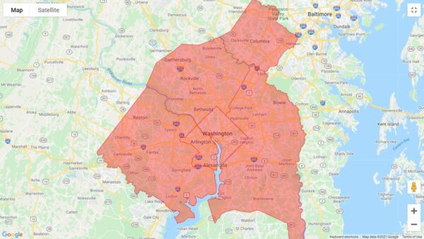
A Flash Flood Watch has been issued for the D.C. area, including Fairfax County.
The alert will take effect at 1 p.m. and is currently set to expire at 11 p.m., as the National Weather Service says “numerous showers and thunderstorms” are expected to pass through the region this afternoon and evening.
While just up to an inch of rain is projected to fall on average, the thunderstorms could bring heavy rainfall within a short period of time to localized areas, potentially leading streams and creeks to flood.
Here is the full NWS alert:
…FLASH FLOOD WATCH IN EFFECT FROM 1 PM EDT THIS AFTERNOON THROUGH
THIS EVENING…The National Weather Service in Sterling Virginia has issued a
* Flash Flood Watch for portions of DC, central Maryland and northern Virginia, including the following areas: in DC, District of Columbia. In central Maryland, Central and Southeast Howard, Central and Southeast Montgomery and Prince Georges. In northern Virginia, Arlington/Falls Church/Alexandria and Fairfax.
* From 1 PM EDT this afternoon through this evening.
* Numerous showers and thunderstorms are expected this afternoon and evening. Average rainfall amounts are expected to be between one half to one inch. However, thunderstorms will be capable of
producing very heavy rainfall rates of 2 to 3 inches per hour, causing localized amounts of 2 to 4 inches possible. While storms are possible any time this afternoon through this evening, the most widespread thunderstorm activity is most likely to be late this afternoon through early this evening.* Heavy rainfall amounts in a short period of time may result in rapid rises on streams and creeks as well as the potential for flash flooding in urban areas.
PRECAUTIONARY/PREPAREDNESS ACTIONS…
You should monitor later forecasts and be prepared to take action should Flash Flood Warnings be issued.
Today’s anticipated showers come after a relatively brief thunderstorm took out power for thousands of people in McLean.
The issues appear to have been largely addressed overnight, but Dominion Energy’s outage map shows a handful of customers still waiting for electricity to be restored, including 24 people east of Dolley Madison Estates Park. A crew is assessing the damage, and the estimated time of restoration is 11 a.m. to 4 p.m.
[8/27 at 8:41 AM] A Flash Flood Watch is in effect today from 1 PM to 11 PM. Numerous showers & t'storms are expected during this time. Heavy rainfall amounts in a short period of time may result in rapid rises on streams & creeks as well as cause flash flooding on roads. #VaWx pic.twitter.com/BYIlGyn8ft
— Ready Fairfax (@ReadyFairfax) August 27, 2021
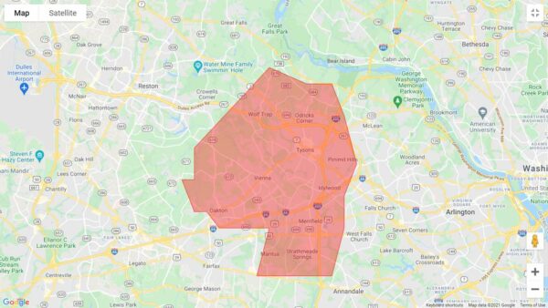
(Updated at 10:15 a.m.) A Flash Flood Warning has been issued for much of northeastern Fairfax County with a particular emphasis on the Tysons and Vienna area.
By 8 a.m., between one and three inches of rain had already fallen, and instances of flash flooding have been reported throughout the morning. The National Weather Service alert warned of “life threatening flash flooding of creeks and streams, urban areas, highways, streets, and underpasses.”
The alert is in effect until 11:45 a.m.
9:02 am: Numerous reports of flooding continue to come in from near Vienna/Tysons into the District. Rainfall rates of as much as an inch in 15 to 20 minutes or three inches per hour. Best to continue to stay off local roads unless absolutely necessary. https://t.co/KkgWXGd3jT pic.twitter.com/1OOYCNyee6
— Capital Weather Gang (@capitalweather) August 20, 2021
Police also reported that several roads have closed due to flooding, including Arlington Boulevard (Route 50) at Prosperity Avenue in the Merrifield area.
By 10:02 a.m., Beulah Road at Browns Mill Road in Wolf Trap, Hilltop Avenue at Cedar Lane in Dunn Loring, and Georgetown Pike at Swinks Mill Road by Scott’s Run were added to the list of flooding-induced road closures.
“Turn around, don’t drown when encountering flooded roads,” the NWS said in a flood warning for the DC region this morning. “Most flood deaths occur in vehicles.”
At least one person got stuck in a vehicle in the Vienna area on Old Courthouse and Beasley roads but self-evacuated, the Fairfax County Fire and Rescue Department said.
UPDATE: driver self evacuated. No injuries. All units returning to service. Roadway will be closed. Seek alternate route. #FCFRD encourages drivers to #TurnAroundDontDrown! Don't drive into flooded roads or around barriers closing roads. #weather #traffic https://t.co/lFRbDeUxc2
— Fairfax County Fire/Rescue (@ffxfirerescue) August 20, 2021
The fire department also responded to a fallen tree in the McLean area that crashed into a home in the 800 block of Dolley Madison Boulevard and toppled an oil tanker.
Units on scene of a tree into a home in the 800 block of Dolley Madison Boulevard in McLean area. Medium size tree fell. Minimal damage. All occupants safe. Oil tank toppled over. Haz Mat crews evaluating. Situation stable. Most units returning to service. #FCFRD #weather pic.twitter.com/xuMvmlIxId
— Fairfax County Fire/Rescue (@ffxfirerescue) August 20, 2021
Emergency responders said they expect several calls for help as people attempt to drive through flooded, and sometimes closed, roadways “only to stall and become trapped.”
They encouraged people to seek alternate routes and plan their travel.
A flash flood watch, which means flooding is possible, also involved part of DC and areas of Maryland (including Bethesda, Potomac, Rockville, and surrounding areas) for this morning. An earlier alert, also a flash flood watch, identified other parts of Virginia (such as Manassas and Stafford).
“Heavy rainfall may result in rapid rises on streams, creeks, and in urban and poor drainage areas,” the NWS said.
The NWS also says that isolated severe thunderstorms, and some possible flooding, could occur on Saturday and Sunday (Aug. 21 and 22) as a slow-moving system approaches from the Great Lakes this weekend.
Photo via NWS
Flash Flood Watch in Effect — The National Weather Service has issued a Flash Flood Watch for Fairfax County and the rest of the D.C. area through 10 p.m. today (Wednesday). Multiple rounds of heavy showers and thunderstorms could drop up to one to two inches of rain per hour, leading to rapid rises in streams, creeks, and poor drainage areas. [NWS]
Metro to Require Employee Vaccinations — Metro workers must be vaccinated against COVID-19 or submit to weekly testing in a new policy that General Manager Paul J. Wiedefeld announced in an internal memo yesterday (Tuesday). 45% of the transit agency’s 12,000-person workforce is fully vaccinated, falling short of the 70% goal set by Metro leaders earlier this month. [The Washington Post]
County Seeks Input on Hazard Mitigation Plan — The Fairfax County Office of Emergency Management has partnered with other jurisdictions across the region to update the Northern Virginia Hazard Mitigation Plan, which aims to reduce or eliminate the dangers posed by flooding, tornadoes, and other disasters. A survey to help the county identify potential risks and prepare for them is open until Sept. 20. [Fairfax County Emergency Information]
Fire Station Makes Department History — “For the first time in the history of the Fairfax County Fire and Rescue Department in Virginia, the day-to-day operations of a fire station are being run entirely by women. Capts. Felicia Barnes, Katja Lancing and Emily Murphy all work at Kingstowne Fire Station 37 on Telegraph Road.” [WTOP]
Updated at 4:25 p.m. — A Severe Thunderstorm Warning has now been issued for Fairfax County. In effect until 5 p.m., storms are moving east at 15 miles per hour with 60 mile-per-hour wind gusts that could bring down trees and large branches, potentially leading to power outages.
Earlier: Fairfax County is still in the process of recovering from last night’s storm, and the next one is already on the way.
The National Weather Service has put the entire D.C. region under a Severe Thunderstorm Watch until 9 p.m., warning of the potential for hail and damaging winds similar to the blasts that disrupted travel and power in the Vienna and Falls Church area yesterday (Tuesday).
A Severe Thunderstorm Watch has been issued until 9 PM this evening for all areas east of the Allegheny Front. Damaging winds and large hail will be the primary threat for these storms. pic.twitter.com/CXqq3C1nP4
— NWS Baltimore-Washington (@NWS_BaltWash) August 11, 2021
[8/11 at 2:15 PM] ⚠️A Severe Thunderstorm Watch is in effect until 9 PM tonight. Potential hazards from these storms include: damaging wind gusts, hail, lightning, and isolated flash flooding. Be prepared to move indoors and know what to do if a warning is issued. #VaWx #BeReady pic.twitter.com/4nGV078aXl
— Ready Fairfax (@ReadyFairfax) August 11, 2021
In addition, a Heat Advisory will remain in effect until 8 p.m. today with an Excessive Heat Watch scheduled to begin at noon tomorrow (Thursday), when the heat index could reach up to 105 degrees Fahrenheit.
Updated at 9:45 p.m. — Metro has restored service on the Orange Line between Vienna and East Falls Church after it was suspended earlier due to a power outage at the West Falls Church Metro station.
Earlier: A thunderstorm has taken out power for thousands in the Tysons area, particularly around Vienna, Falls Church, and Merrifield.
The National Weather Service issued a Severe Thunderstorm Warning for northeastern Fairfax County at 5:12 p.m., though by that time, the rumble of thunder had likely alerted anyone in the area.
Moving east at 15 miles per hour, the storm brought 60 mile-per-hour wind gusts, according to the NWS, which warned about the potential for fallen trees and large branches.
“This could injure those outdoors, as well as damage homes and vehicles,” the alert said. “Roadways may become blocked by downed trees. Localized power outages are possible. Unsecured light objects may become projectiles.”
The storm arrived quickly, leaving many unprepared.
Prob should have put the umbrellas down in Tysons. This poor guy. @nbcwashington pic.twitter.com/9SZTfvOlrd
— Adam Tuss (@AdamTuss) August 10, 2021
At least 51,423 Dominion Energy customers in Fairfax County are now without power, according to the site PowerOutage.US.
Dominion Energy’s outage map shows many of the outages concentrated in Falls Church, Merrifield, and Vienna, where businesses in the commercial area along Maple Avenue and Church Street were among those that lost electricity.
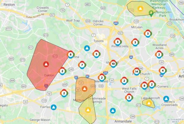
Dominion Energy generally estimates that power will be restored between 7 p.m. and midnight, though the cause of some outages is still under investigation. Most of the outages have been attributed to out circuits, but one affecting more than 5,000 people around Vienna and Oakton is the result of a tree falling on a power line.
Metro has suspended service on the Orange Line between Vienna and East Falls Church due to a loss of power at the West Falls Church station. The transit agency says shuttle buses have been requested.
Orange Line Delay: Train service suspended between Vienna & E Falls Church due to a power outage at W Falls Church. Shuttle buses requested.
— Metrorail Info (@Metrorailinfo) August 10, 2021
Power out in Dunn Loring too pic.twitter.com/xwAP95RWMY
— James Holcombe (@jameslholcombe) August 10, 2021
Even with the thunderstorm, Fairfax County can expect little relief from the summer heat and humidity over the next couple of days, with the heat index expected to surpass 100 degrees tomorrow and on Thursday (Aug. 12).

While temperatures in Fairfax County haven’t exactly been comfortable over the past couple of days, the heat is about get worse before easing up at the end of this week.
The National Weather Service has issued a Heat Advisory for the D.C. area, including Fairfax County, that will take effect from noon through 8 p.m. tomorrow (Wednesday). An Excessive Heat Watch will follow on Thursday (Aug. 12) over roughly the same time frame.
Forecasts indicate high temperatures of 95 degrees tomorrow and 99 degrees on Thursday in Tysons, but the addition of humidity could make it feel like more than 100 degrees.
Here is more from the alert:
* WHAT…For the Heat Advisory, heat index values will range from around 100 degrees west of Interstate 95 to around 105 degrees near and east of Interstate 95. For the Excessive Heat Watch, dangerously hot conditions are possible with heat indices possibly ranging from around 105 degrees west of Interstate 95 to around 110 degrees near and east of Interstate 95.
* WHERE…The Washington, Baltimore, and Fredericksburg areas, central and southern Maryland, northern Virginia, and the eastern panhandle of West Virginia.
* WHEN…For the Heat Advisory, from noon to 8 PM EDT Wednesday. For the Excessive Heat Watch, from Thursday afternoon through early Thursday evening.
* IMPACTS…Extreme heat and humidity will significantly increase the potential for heat related illnesses, particularly for those working or participating in outdoor activities.
The NWS advises preparing for the incoming heat by drinking plenty of fluids, staying out of the sun and in air-conditioned rooms when possible, and checking in on relatives and neighbors.
“Young children and pets should never be left unattended in vehicles under any circumstances,” the NWS says in the alert. “This is especially true during warm or hot weather when car interiors can reach lethal temperatures in a matter of minutes.”
A Heat Advisory has been issued for portions of our area Wednesday as increased heat and humidity will result in heat indices ranging between 100-105 degrees. Slightly hotter conditions expected Thursday, prompting an Excessive Heat Watch. https://t.co/JxQPRW87Gr pic.twitter.com/SbRldDZPPF
— NWS Baltimore-Washington (@NWS_BaltWash) August 10, 2021
Stay safe this summer and KNOW the symptoms of heat-related illness! ☀️🌡
⬇️Heat safety tips
💧Stay hydrated
🌳Find shade
👶Don't leave kids/pets unattended
🤝Check up on neighbors
🚗LOOK before you LOCKMore info
➡️https://t.co/mZEhRFo8WJ pic.twitter.com/TYUBzq7qWE— Supervisor John Foust (@DranesvilleSup) August 10, 2021
Photo via Ritam Baishya/Unsplash
Like much of the D.C. area, Fairfax County is now under a Severe Thunderstorm Watch that will be in place until 9 p.m.
The region is bracing for a second consecutive night of potentially damaging wind and rainfall after a storm that swept through late Wednesday (July 28) resulted in power outages that affected thousands of people in Fairfax County, particularly around McLean and Falls Church.
While many of the outages have been addressed, Dominion Energy’s outage map shows that, as of 3:30 p.m., crews are still working to restore electricity in some areas. The current estimated time of restoration for the lingering outages ranges from before 5 p.m. to 6-11 p.m.
A Tornado Watch has been issued for D.C.’s Maryland suburbs, but Fairfax County could see damaging hail, isolated flash flooding, and large hail from the incoming storm, according to the National Weather Service.
The Fairfax County Office of Emergency Management advises residents to “stay weather aware and know what to do if a warning is issued,” which would mean that severe weather is imminent or underway.
A Severe Thunderstorm Watch has been issued for areas outside of the Tornado Watch, both of which are until 9 PM tonight. Main threat for these storms will be for damaging winds, large hail, isolated flash flooding and tornadoes. pic.twitter.com/eNM7nyBtFK
— NWS Baltimore-Washington (@NWS_BaltWash) July 29, 2021


