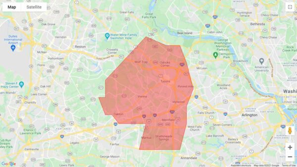
(Updated at 10:15 a.m.) A Flash Flood Warning has been issued for much of northeastern Fairfax County with a particular emphasis on the Tysons and Vienna area.
By 8 a.m., between one and three inches of rain had already fallen, and instances of flash flooding have been reported throughout the morning. The National Weather Service alert warned of “life threatening flash flooding of creeks and streams, urban areas, highways, streets, and underpasses.”
The alert is in effect until 11:45 a.m.
9:02 am: Numerous reports of flooding continue to come in from near Vienna/Tysons into the District. Rainfall rates of as much as an inch in 15 to 20 minutes or three inches per hour. Best to continue to stay off local roads unless absolutely necessary. https://t.co/KkgWXGd3jT pic.twitter.com/1OOYCNyee6
— Capital Weather Gang (@capitalweather) August 20, 2021
Police also reported that several roads have closed due to flooding, including Arlington Boulevard (Route 50) at Prosperity Avenue in the Merrifield area.
By 10:02 a.m., Beulah Road at Browns Mill Road in Wolf Trap, Hilltop Avenue at Cedar Lane in Dunn Loring, and Georgetown Pike at Swinks Mill Road by Scott’s Run were added to the list of flooding-induced road closures.
“Turn around, don’t drown when encountering flooded roads,” the NWS said in a flood warning for the DC region this morning. “Most flood deaths occur in vehicles.”
At least one person got stuck in a vehicle in the Vienna area on Old Courthouse and Beasley roads but self-evacuated, the Fairfax County Fire and Rescue Department said.
UPDATE: driver self evacuated. No injuries. All units returning to service. Roadway will be closed. Seek alternate route. #FCFRD encourages drivers to #TurnAroundDontDrown! Don't drive into flooded roads or around barriers closing roads. #weather #traffic https://t.co/lFRbDeUxc2
— Fairfax County Fire/Rescue (@ffxfirerescue) August 20, 2021
The fire department also responded to a fallen tree in the McLean area that crashed into a home in the 800 block of Dolley Madison Boulevard and toppled an oil tanker.
Units on scene of a tree into a home in the 800 block of Dolley Madison Boulevard in McLean area. Medium size tree fell. Minimal damage. All occupants safe. Oil tank toppled over. Haz Mat crews evaluating. Situation stable. Most units returning to service. #FCFRD #weather pic.twitter.com/xuMvmlIxId
— Fairfax County Fire/Rescue (@ffxfirerescue) August 20, 2021
Emergency responders said they expect several calls for help as people attempt to drive through flooded, and sometimes closed, roadways “only to stall and become trapped.”
They encouraged people to seek alternate routes and plan their travel.
A flash flood watch, which means flooding is possible, also involved part of DC and areas of Maryland (including Bethesda, Potomac, Rockville, and surrounding areas) for this morning. An earlier alert, also a flash flood watch, identified other parts of Virginia (such as Manassas and Stafford).
“Heavy rainfall may result in rapid rises on streams, creeks, and in urban and poor drainage areas,” the NWS said.
The NWS also says that isolated severe thunderstorms, and some possible flooding, could occur on Saturday and Sunday (Aug. 21 and 22) as a slow-moving system approaches from the Great Lakes this weekend.
Photo via NWS


