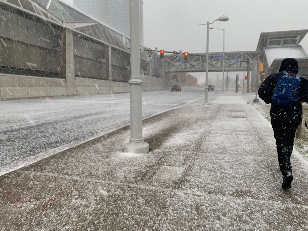
(Updated at 4:35 p.m.) Fairfax County, including Vienna, Pimmit Hills and McLean, was under a Severe Thunderstorm Warning as a line of storms rolled through the area Friday afternoon.
The storms brought gusty winds, hail and graupel to Tysons, McLean, Vienna and Falls Church.
“That was sudden. I’ve lived here 30 years and I never saw anything like that,” said one local resident at the Greensboro Metro station amid the storm.
More from the National Weather Service:
THE NATIONAL WEATHER SERVICE IN STERLING VIRGINIA HAS ISSUED A * SEVERE THUNDERSTORM WARNING FOR… CENTRAL MONTGOMERY COUNTY IN CENTRAL MARYLAND… LOUDOUN COUNTY IN NORTHERN VIRGINIA… THE CITY OF FAIRFAX IN NORTHERN VIRGINIA… FAIRFAX COUNTY IN NORTHERN VIRGINIA… * UNTIL 415 PM EDT. * AT 326 PM EDT, SEVERE THUNDERSTORMS WERE LOCATED ALONG A LINE EXTENDING FROM NEAR POINT OF ROCKS TO NEAR BLUEMONT, MOVING EAST AT 55 MPH. HAZARD…60 MPH WIND GUSTS. SOURCE…RADAR INDICATED. IMPACT…DAMAGING WINDS WILL CAUSE SOME TREES AND LARGE BRANCHES TO FALL. THIS COULD INJURE THOSE OUTDOORS, AS WELL AS DAMAGE HOMES AND VEHICLES. ROADWAYS MAY BECOME BLOCKED BY DOWNED TREES. LOCALIZED POWER OUTAGES ARE POSSIBLE. UNSECURED LIGHT OBJECTS MAY BECOME PROJECTILES. * LOCATIONS IMPACTED INCLUDE… GERMANTOWN, CENTREVILLE, ROCKVILLE, BETHESDA, GAITHERSBURG, RESTON, LEESBURG, OLNEY, SOUTH RIDING, HERNDON, FAIRFAX, VIENNA, BROADLANDS, LANSDOWNE, LOWES ISLAND, BRAMBLETON, MANTUA, PIMMIT HILLS, POOLESVILLE AND MCLEAN. PRECAUTIONARY/PREPAREDNESS ACTIONS… GET INDOORS TO PROTECT YOURSELF FROM WIND AND LIGHTNING. TREES AROUND YOU MAY BE DOWNED FROM DAMAGING WINDS, SO IF YOU ARE NEAR LARGE TREES, MOVE TO AN INTERIOR ROOM ON THE LOWEST FLOOR. DON’T DRIVE UNDERNEATH TREES OR IN WOODED AREAS UNTIL THE THREAT HAS PASSED. && HAIL…<.75IN WIND…60MPH
Severe Thunderstorm Warning including Germantown MD, Centreville VA, Rockville MD until 4:15 PM EDT pic.twitter.com/j8AHW54arR
— NWS Baltimore-Washington (@NWS_BaltWash) March 22, 2019
@dougkammerer hail storm in Vienna…ground now covered…so cool…thunder and lightning not so much. pic.twitter.com/l3rRWNZd1V
— Dan Fredericks (@fmdano74) March 22, 2019
https://twitter.com/marcussimon/status/1109183488530567168
What exactly is going on outside? Snow? Hail? Shnail? Either way, headlights on! pic.twitter.com/TFeniA9GBU
— City of Falls Church (@FallsChurchGov) March 22, 2019

(Updated at 4:35 p.m.) Fairfax County Public Schools will be closed tomorrow (Wednesday) due to a winter storm that’s just hours away from reaching the area.
Due to the winter storm warning in effect for our area, all Fairfax County public schools and offices will be closed Wednesday, Feb. 20, 2019 (Condition 1).
— Fairfax Schools 🌟 (@fcpsnews) February 19, 2019
A Winter Storm Warning has been issued ahead of the storm, which is expected to drop several inches of snow and some sleet and freezing rain on Fairfax County.
Despite VDOT pretreating local roadways, authorities are urging residents to stay off the roads — if at all possible — after the flakes start flying early Wednesday morning. Delays and cancellations are likely for schools, governments and flights Wednesday.
More from the National Weather Service:
…WINTER STORM WARNING REMAINS IN EFFECT FROM 1 AM TO 7 PM EST WEDNESDAY… * WHAT…HEAVY MIXED PRECIPITATION EXPECTED. TOTAL SNOW ACCUMULATIONS OF 3 TO 6 INCHES AND ICE ACCUMULATIONS OF UP TO ONE TENTH OF AN INCH EXPECTED. * WHERE…THE DISTRICT OF COLUMBIA AND PORTIONS OF CENTRAL MARYLAND AND CENTRAL AND NORTHERN VIRGINIA. * WHEN…FROM 1 AM TO 7 PM EST WEDNESDAY. SNOW WILL OVERSPREAD THE AREA EARLY WEDNESDAY MORNING AND MIX WITH AND CHANGE TO SLEET AND FREEZING RAIN DURING THE LATE MORNING AND EARLY AFTERNOON HOURS WEDNESDAY. PRECIPITATION WILL CHANGE TO PLAIN RAIN WEDNESDAY EVENING. THE HEAVIEST SNOW IS LIKELY WEDNESDAY MORNING. * ADDITIONAL DETAILS…TRAVEL COULD BE VERY DIFFICULT. THE HAZARDOUS CONDITIONS COULD IMPACT THE MORNING OR EVENING COMMUTE. PRECAUTIONARY/PREPAREDNESS ACTIONS… A WINTER STORM WARNING MEANS SIGNIFICANT AMOUNTS OF SNOW, SLEET AND ICE WILL MAKE TRAVEL VERY HAZARDOUS OR IMPOSSIBLE. WHEN VENTURING OUTSIDE, WATCH YOUR FIRST FEW STEPS TAKEN ON STEPS, SIDEWALKS, AND DRIVEWAYS, WHICH COULD BE ICY AND SLIPPERY, INCREASING YOUR RISK OF A FALL AND INJURY. &&
More via social media:
ToV trash pick-up, parks and rec classes, and the Planning Commission work session for tmo have been canceled due to impending weather conditions. Find out more at https://t.co/Z0CXA988uL.
— Town of Vienna, VA (@TownofViennaVA) February 19, 2019
PLEASE SHARE :: As of 7pm on Tuesday, February 19, the #CityOfFallsChurch Snow Emergency Routes are in effect. All vehicles parked on those routes must be moved or risk ticketing or towing. List of routes: https://t.co/JfYPsW2B6W. pic.twitter.com/W1s1aoxGNo
— City of Falls Church (@FallsChurchGov) February 19, 2019
The upcoming winter storm will transition through multiple precipitation types Wednesday into Wednesday evening before gradually ending. Travel conditions could quickly deteriorate Wednesday morning as the initial burst of snow moves across the area. pic.twitter.com/yeLiN35UJk
— NWS Baltimore-Washington (@NWS_BaltWash) February 19, 2019
Ok Friends, here’s your reminder to get all of your essential errands done this afternoon. Fill up your gas tank and wiper fluid basin, get 🥛🍞🧻, make your plan to telework tmrw or adjust your commute to stay off the roads Wed. Our trucks need room to work. #safetyalways pic.twitter.com/k2BJUjewr5
— VDOT Northern VA (@VaDOTNOVA) February 19, 2019
We’ve been watching the weather forecast closely and are prepared should snow and ice impact parts of our service area in the coming days. Remember to always report your outage by calling 1-866-DOM-HELP or by using your smartphone to report it at https://t.co/6jaxYP2BQB. pic.twitter.com/KrhP82U7IN
— Dominion Energy (@DominionEnergy) February 19, 2019

Winter Storm Approaching — Some 2-5 inches of snow are expected to fall on the Tysons area Wednesday. Much of the region is now under a Winter Storm Warning. [Capital Weather Gang, Twitter]
FRIT Opening Tysons Office — Maryland-based Federal Realty Investment Trust, which owns the Pike 7 shopping center, is planning to open an office in Tysons to better manage its Northern Virginia properties. [Washington Business Journal]
Sheriff’s Office Alerts ICE — “The Fairfax County Sheriff’s Office notifies U.S. Immigration and Customs Enforcement authorities when a possibly undocumented immigrant in its custody is scheduled to be released, a written notice given to inmates says.” [Fairfax Times]
Programming Note — For those of you used to seeing Morning Notes on this site, or on our sister sites of ARLnow and Reston Now, we’re changing things up a bit here. Instead of a daily post, we will now be doing a once-weekly roundup of Tysons, McLean, Vienna and Falls Church-related items in the news since last Friday.

Virginia Governor Ralph Northam declared a state of emergency tonight (Saturday) as this weekend’s winter storm got underway.
The storm is expected to drop 6-12 inches of snow on Fairfax County over the next 24 hours or so.
Snow is now accumulating on local yards, parking lots and side roads throughout the county. A Winter Storm Warning, meanwhile, is in effect through Sunday evening.
From the National Weather Service:
…WINTER STORM WARNING REMAINS IN EFFECT UNTIL 6 PM EST SUNDAY… * WHAT…HEAVY SNOW EXPECTED. TOTAL SNOW ACCUMULATIONS OF 5 TO 10 INCHES EXPECTED. * WHERE…THE DISTRICT OF COLUMBIA, PORTIONS OF CENTRAL MARYLAND AND NORTHERN AND NORTHWEST VIRGINIA. * WHEN…UNTIL 6 PM EST SUNDAY. * ADDITIONAL DETAILS…TRAVEL COULD BE VERY DIFFICULT DUE TO SNOW COVERED AND SLIPPERY ROADS. PRECAUTIONARY/PREPAREDNESS ACTIONS… A WINTER STORM WARNING FOR SNOW MEANS SEVERE WINTER WEATHER CONDITIONS WILL MAKE TRAVEL VERY HAZARDOUS OR IMPOSSIBLE. IF YOU MUST TRAVEL, KEEP AN EXTRA FLASHLIGHT, FOOD AND WATER IN YOUR VEHICLE IN CASE OF AN EMERGENCY. THE LATEST ROAD CONDITIONS FOR THE STATE YOU ARE CALLING FROM CAN BE OBTAINED BY CALLING 5 1 1. &&
VDOT, which is responsible for clearing snow from roads in Fairfax County — except for those that are privately owned — is urging residents to remain inside during the storm if at all possible.
More from social media:
Friends, if you’re out and about, please finish up whatever you’re doing. We’d like you off the roads during the height of the storm. We continue to load and deploy trucks and are prepared for some unpleasant driving conditions later. pic.twitter.com/X9MvSXfktH
— VDOT Northern VA (@VaDOTNOVA) January 12, 2019
Who Does What: Snow Removal. A handy reminder as we go into our first snow of 2019 pic.twitter.com/fgGYmI1Xxt
— Fairfax County Government 🇺🇸 (@fairfaxcounty) January 12, 2019
Expected #snow totals have increased. We urge our community members to please stay home and allow #VaDOTNOVA to work on clearing the roadways. Tips for driving in #inclementweather, visit this link: https://t.co/EIBLpDcGf8 #FairfaxCounty #FCPD ❄️🚗 pic.twitter.com/e9QNp5k1BS
— Fairfax County Police (@FairfaxCountyPD) January 12, 2019
Here we go! First snow of 2019! Our crews are ready for the Winter Storm Warning. Have you checked on neighbors in need? Plan to clear the fire hydrant by your house? Staying off the roads? Stay safe and warm!! pic.twitter.com/V6TNUTvhaC
— City of Falls Church (@FallsChurchGov) January 13, 2019
Love walking in the snow – McLean @capitalweather pic.twitter.com/ltyIe3ppyA
— B (@blb99) January 13, 2019